And the dog came too... dog walks in New Zealand
  • Home
  • Introduction
  • Notes for Users
  • Alarums and Excursions!!
  • South Island
    • North-West >
      • Atua Stream Walk
      • Barnicoat
      • Ben Nevis
      • Botanical Hill
      • Boulder Bank
      • Brooklyn
      • Collingwood Beach
      • Collingwood Cemetery
      • Cotterell Road
      • Dellside
      • Dicker Road
      • Dominion Flats
      • Eves Valley Road
      • Faulkner Bush
      • Grampians
      • Great Taste Trail - Richmond
      • Great Taste Trail - Kohatu
      • Great Taste Trail - Wakefield
      • Hacket Valley
      • Hoddy Estuary Reserve
      • Hoddy Road
      • Kawatiri Rail Tunnel walk
      • Kina Beach
      • Maitai Valley
      • Mapua Headland
      • Marahau Beach
      • Marahau Forest
      • Mead Stream
      • Milnthorpe Forest
      • Motueka Inlet
      • Motueka Spit
      • Pakawau Beach
      • Paton's Rock
      • Paynes Ford Tramline Track
      • Pearse Valley
      • Pohara Beach
      • Rameka Creek
      • Red Hills
      • Ridgeview Road Walkway
      • Robson Reserve
      • Rough Island
      • Sharlands
      • Split Apple Rock
      • Stagecoach Road
      • St Arnaud Loop Walk
      • Tahunanui Beach
      • Tantragee
      • Tasman View Road
      • Teetotal
      • Two Rivers
      • Waimea Fish-Out Ponds
      • Waimea River Trail
      • Wairoa River Left Branch
      • Waiwhero Forest
      • Waiwhero Ridge
    • North-East >
      • Archer's Track
      • Blairich Reserve
      • Cullen Creek
      • Cullen Point
      • Davies Bay Track
      • Esson's Valley Tracks
      • Goulter River
      • Grovetown Lagoon
      • Half Moon Track
      • Kotuku Trail
      • Lake Chalice
      • Link Trail East
      • Link Trail West
      • Lower Wairau
      • Mount Baldy and Mount Royal
      • Mount Barrett Walkway
      • Mount Fell
      • Mount Fishtail
      • Mount Richmond
      • Mount Riley
      • Mount Robertson
      • Mount Stokes
      • Mount Takorika
      • Ngakuta Bay
      • Nydia Track
      • Opouri Bridle Track
      • Patutu Walk
      • Pelorus Track
      • Piwakawa Track
      • Rarangi
      • Sawcut Gorge
      • Snout Tracks
      • Taylor's Valley
      • Tirohanga
      • Wairau River
      • Wakamarina Track
    • West >
      • Alborns Track
      • Big Rimu Tree walk
      • Charming Creek
      • Chasm Creek
      • Coalbrookdale
      • Denniston Historic Walkway
      • Denniston Plateau
      • Gentle Annie Point walk
      • Goldsborough Tracks
      • Haast-Paringa Cattle Track
      • Kawatiri Beach Trail
      • Kawatiri River Trail
      • Kumara Community walks
      • Lake Hanlon
      • Larry's Creek
      • Mikonui River
      • Millerton Bathhouse Track
      • Moeraki Valley Track
      • Mokihinui Stopbank
      • Mount Adams
      • Mount Glasgow
      • Mount Haast Route
      • Murchison Tree Walks
      • Murray Creek
      • Old Ghost Road
      • Porika Road
      • Powerhouse and Lookout Walks
      • Progress Water Race
      • Ross Goldfield Walks
      • Skyline Walk
      • Stafford Bay Loop
      • Wanganui River
      • Whataroa Walks
      • Whitcombe Loop Tracks
      • Whitcombe Valley Track
      • Zig-Zag Track
    • Central-North >
      • Balmoral Lookout
      • Bottle Lake
      • Cheviot Hills Reserve
      • Childrens Bay Farm
      • Craigieburn Forest
      • Culverden Domain
      • Diamond Harbour
      • Ellangowan Scenic Reserve
      • Garden of Tane
      • Godley Head
      • Governors Bay
      • Halswell Quarry
      • Hanmer Forest Walks
      • H W Hart Arboretum
      • Ka Whata Tu o Rakihouia
      • Kaikoura Trail
      • Kowai Bush Reserve
      • Kowai River
      • Lyttleton Coastal Walk
      • Lytteleton Hills
      • McCleans Forest
      • McHughs Forest Park
      • Mears Bush
      • Mount Grey
      • Mount Oxford
      • Mount Richardson
      • Mount Thomas
      • Newton Falls
      • Ngaio Point
      • Panama Rock
      • Pegasus Bay
      • Rakahuri River
      • Sign of the Bellbird
      • Sign of the Kiwi
      • St James Conservation Park
      • Tutakakahikura Scenic Reserve​
      • Victoria Park
      • West Melton Forest
      • Woodills North
      • Woodills South
    • Central-South >
      • Ahuriri East Branch
      • Ahuriri Valley Tracks
      • Ashburton River
      • Benmore Peninsula
      • Centennial Park
      • Cowan's Hill
      • Dingle Burn
      • Double Hill
      • Freehold Creek
      • Greta and Dorcy Tracks
      • Gunns Bush
      • Hook Bush
      • Huxley and Hopkins Valleys
      • Kelceys Bush
      • Knottingly Park
      • Lake Emma walk
      • Lake Emily Tracks
      • Lake Hood
      • Lake Ohau Track
      • Lake Opuha Walk
      • Lake Tekapo Lakeside Walk
      • Lake Tekapo Regional Park
      • Lake Wainono
      • Lower Opihi River Track
      • Macaulay River walk
      • Methven walkway
      • Mount Barrosa
      • Mount Sunday & Mount Potts
      • Opihi River Walkway
      • Orari River Mountain Bike Tracks
      • Pareora River
      • Pioneer Park
      • Potts River Walks
      • Quailburn Track
      • Saltwater Creek
      • Snowy Gorge
      • Talbot Forest
      • Temple Valley Tracks
      • Waihao River
      • Waihi River Walk
      • Waimate Creek walks
      • Waitohi Bush
    • South-East >
      • Alexandra Anniversary Walk
      • Arawata Bridle Track
      • Arrow Gorge Loop
      • Arrowtown Millennium Track
      • Bannockburn Sluicings
      • Bob's Cove and Twelve Mile Delta
      • Boundary Creek
      • Bull Creek
      • Bullendale Track
      • Butcher's Dam
      • Central Otago Rail Trail
      • Chrystals Beach
      • Clutha Riverside Track
      • Commissioner's Track
      • Conroy's Dam
      • Cromwell-Pisa Walkway
      • Crystal Battery
      • Deans Bank Track
      • Diamond Creek Track
      • Dunedin Walks
      • Earnscleugh Tailings
      • Flagstaff Hill
      • Frankton Arm Walkway
      • Gabriel's Gully
      • Gibbston River Trail
      • Gladstone Track
      • Glendhu Bay Track
      • Glenorchy Boardwalk
      • Grovers Hill
      • Hawea River Track
      • Huriawa Pa Walk
      • Kanuka Loop
      • Lake Alta Track
      • Lake Hayes Trail
      • Lakeside Walk
      • Leith Saddle
      • Long Beach
      • Mapoutahi
      • Mosgiel Floodbank
      • Mount Cargill
      • Mount Crichton Loop
      • Mount Iron Track
      • Munro's Gully
      • Naseby Forest
      • Nevis Valley Tracks
      • Newcastle Track
      • One MIle Creek
      • Oteake Conservation Park
      • Outram Glen
      • Quartz Reef
      • St Bathans
      • Trotters Gorge
    • South-West >
      • Blair Athol Walkway
      • Boyd Creek
      • Manapouri cycleway
      • McLean Falls
      • The Bluff
  • North Island
    • Auckland & Waiheke
    • Coromandel & North Waikato
    • Wellington
    • The North
    • Manawatu & Wairarapa
    • The East
    • Taranaki & Central
  • Useful Links
  • Progress Water Race
  • Rock and Pillar Conservation Park
  • New Page
  • New Page
  • New Page
  • New Page
  • New Page
  • New Page

Archer's Track

A long but easy walk along the edge of the beautiful Tennyson Inlet

Return to Regional Page

​Archer's Track

Name
Archer's Track
Location
Elaine Bay
Co-ordinates
1664321  5451427
Alternative co-ordinates
1665102  5454878
Configuration
Linear
Distance
9 km
Status
On-leash
Grade
Easy-Moderate
Access
Ca. 1 km north of Rai Valley, take Opouri Road off SH6 and follow it right over the Rai River. Continue over Opouri Saddle and at the bottom of the hill turn left onto Archers Road. Track starts by car park in Penzance Bay (head uphill across field to pick up track). Walk can also be started at Elain Bay (off Croisilles-French Pass Road). DoC permit required for dogs; contact Picton DoC office (picton@doc.govt.nz)
Description
A lengthy and pleasing walk along the edge of the Tennyson Inlet. Easy going most of the way, and giving great views of the sound and the surrounding hills. 
Connecting tracks
 
Further information
http://www.doc.govt.nz/parks-and-recreation/tracks-and-walks/marlborough/sounds/archers-track/
Picture
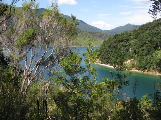
All the walks along the Marlborough Sounds offer delights in terms of glimpsed views of the inlets, the crystal-blue waters, distant islands and headlands between the thick canopies of fern trees and beech. Some, though, have to be hard-won against the terrain, and some are frustratingly brief. Archer's Track suffers from neither of these drawbacks. It is an easy track but satisfyingly long - about 9 km in total - so there-and-back makes for a good full-day walk. It's also varied, and links two neat settlements - Elaine Bay in the north, Penzance Bay in the south - so whichever way you walk it, there's a nice sense of arrival at the other end.

My preferred direction is from north to south, because the best part of the walk is probably the southern half, where the track runs through beautiful native bush, and the because the grassy reserve above the wharf at Penzance Bay provides a great picnic spot. The only disadvantage of doing it this way round is that it entails a long drive in - about an hour in total from SH6, at Carluke, first to Okiwi Bay and then along the winding road over the headland to Elaine Bay. From the carpark at the south end of Elaine Bay, however, it's an easy walk along a private road to the start of the track amid the pine trees of a youngish plantation. For the next hour, the track is a wide bench that runs more-or-less level around the headland, typically with pines on the inland side and native trees on the coastal side, and grass beneath your feet. One hour in and the track drops down into the grassy area beside Deep Bay - a misnomer in many ways for the waters are shallow and - if you don't mind the occasional jelly fish - fine for swimming. Amidst the grass is a private bach, and a useful bench which may or may not also be private - as well as a long drop of similarly uncertain ownership. 

​After that, the track crosses a narrow stream and then climbs back onto the flanks of the headland, to wiggle its way around a headland, and into the next valley - a refrain it repeats five or six times over the next hour or so, until you swing round the last headland and catch a view of the wharf of Penzance Bay. The whole of this section of the track is in native bush, shaded above by the fern trees and beech, made soft underfoot by the leaves, and always well-graded. There are plenty of small streams to cross, several of which provide a good opportunity for the dogs to tank up, and frequent views of Tennyson Inlet and the headland beyond.
The walking is easy, and it's easy to lose yourself in your innermost thoughts as you walk along watching the sunlight dappling around you. After all this, the release into the brightness of Penzance Bay - across a small bridge and into a gravel parking area - comes as a bit of a shock. But in a hundred metres or more you see a grassy field to your left. Hidden in the bushes at the end of the fence there's a path that runs downslope into the reserve, where there are picnic tables and a beach, and another chance for a swim.

Lunch over, it's time to retrace your steps: something our young springer pup couldn't understand the first time we did this walk with him. "What?" his look said: "You mean I've got to walk all the way back again? You must be joking!" ​
​
If you've found this website helpful, you might also want to look at some of my novels and poetry. These, like my dog-walking, are drawn from a love of nature and the countryside. To learn more, click here.