And the dog came too... dog walks in New Zealand
  • Home
  • Introduction
  • Notes for Users
  • Alarums and Excursions!!
  • South Island
    • North-West >
      • Atua Stream Walk
      • Barnicoat
      • Ben Nevis
      • Botanical Hill
      • Boulder Bank
      • Brooklyn
      • Collingwood Beach
      • Collingwood Cemetery
      • Cotterell Road
      • Dellside
      • Dicker Road
      • Dominion Flats
      • Eves Valley Road
      • Faulkner Bush
      • Grampians
      • Great Taste Trail - Richmond
      • Great Taste Trail - Kohatu
      • Great Taste Trail - Wakefield
      • Hacket Valley
      • Hoddy Estuary Reserve
      • Hoddy Road
      • Kawatiri Rail Tunnel walk
      • Kina Beach
      • Maitai Valley
      • Mapua Headland
      • Marahau Beach
      • Marahau Forest
      • Mead Stream
      • Milnthorpe Forest
      • Motueka Inlet
      • Motueka Spit
      • Pakawau Beach
      • Paton's Rock
      • Paynes Ford Tramline Track
      • Pearse Valley
      • Pohara Beach
      • Rameka Creek
      • Red Hills
      • Ridgeview Road Walkway
      • Robson Reserve
      • Rough Island
      • Sharlands
      • Split Apple Rock
      • Stagecoach Road
      • St Arnaud Loop Walk
      • Tahunanui Beach
      • Tantragee
      • Tasman View Road
      • Teetotal
      • Two Rivers
      • Waimea Fish-Out Ponds
      • Waimea River Trail
      • Wairoa River Left Branch
      • Waiwhero Forest
      • Waiwhero Ridge
    • North-East >
      • Archer's Track
      • Blairich Reserve
      • Cullen Creek
      • Cullen Point
      • Davies Bay Track
      • Esson's Valley Tracks
      • Goulter River
      • Grovetown Lagoon
      • Half Moon Track
      • Kotuku Trail
      • Lake Chalice
      • Link Trail East
      • Link Trail West
      • Lower Wairau
      • Mount Baldy and Mount Royal
      • Mount Barrett Walkway
      • Mount Fell
      • Mount Fishtail
      • Mount Richmond
      • Mount Riley
      • Mount Robertson
      • Mount Stokes
      • Mount Takorika
      • Ngakuta Bay
      • Nydia Track
      • Opouri Bridle Track
      • Patutu Walk
      • Pelorus Track
      • Piwakawa Track
      • Rarangi
      • Sawcut Gorge
      • Snout Tracks
      • Taylor's Valley
      • Tirohanga
      • Wairau River
      • Wakamarina Track
    • West >
      • Alborns Track
      • Big Rimu Tree walk
      • Charming Creek
      • Chasm Creek
      • Coalbrookdale
      • Denniston Historic Walkway
      • Denniston Plateau
      • Gentle Annie Point walk
      • Goldsborough Tracks
      • Haast-Paringa Cattle Track
      • Kawatiri Beach Trail
      • Kawatiri River Trail
      • Kumara Community walks
      • Lake Hanlon
      • Larry's Creek
      • Mikonui River
      • Millerton Bathhouse Track
      • Moeraki Valley Track
      • Mokihinui Stopbank
      • Mount Adams
      • Mount Glasgow
      • Mount Haast Route
      • Murchison Tree Walks
      • Murray Creek
      • Old Ghost Road
      • Porika Road
      • Powerhouse and Lookout Walks
      • Progress Water Race
      • Ross Goldfield Walks
      • Skyline Walk
      • Stafford Bay Loop
      • Wanganui River
      • Whataroa Walks
      • Whitcombe Loop Tracks
      • Whitcombe Valley Track
      • Zig-Zag Track
    • Central-North >
      • Balmoral Lookout
      • Bottle Lake
      • Cheviot Hills Reserve
      • Childrens Bay Farm
      • Craigieburn Forest
      • Culverden Domain
      • Diamond Harbour
      • Ellangowan Scenic Reserve
      • Garden of Tane
      • Godley Head
      • Governors Bay
      • Halswell Quarry
      • Hanmer Forest Walks
      • H W Hart Arboretum
      • Ka Whata Tu o Rakihouia
      • Kaikoura Trail
      • Kowai Bush Reserve
      • Kowai River
      • Lyttleton Coastal Walk
      • Lytteleton Hills
      • McCleans Forest
      • McHughs Forest Park
      • Mears Bush
      • Mount Grey
      • Mount Oxford
      • Mount Richardson
      • Mount Thomas
      • Newton Falls
      • Ngaio Point
      • Panama Rock
      • Pegasus Bay
      • Rakahuri River
      • Sign of the Bellbird
      • Sign of the Kiwi
      • St James Conservation Park
      • Tutakakahikura Scenic Reserve​
      • Victoria Park
      • West Melton Forest
      • Woodills North
      • Woodills South
    • Central-South >
      • Ahuriri East Branch
      • Ahuriri Valley Tracks
      • Ashburton River
      • Benmore Peninsula
      • Centennial Park
      • Cowan's Hill
      • Dingle Burn
      • Double Hill
      • Freehold Creek
      • Greta and Dorcy Tracks
      • Gunns Bush
      • Hook Bush
      • Huxley and Hopkins Valleys
      • Kelceys Bush
      • Knottingly Park
      • Lake Emma walk
      • Lake Emily Tracks
      • Lake Hood
      • Lake Ohau Track
      • Lake Opuha Walk
      • Lake Tekapo Lakeside Walk
      • Lake Tekapo Regional Park
      • Lake Wainono
      • Lower Opihi River Track
      • Macaulay River walk
      • Methven walkway
      • Mount Barrosa
      • Mount Sunday & Mount Potts
      • Opihi River Walkway
      • Orari River Mountain Bike Tracks
      • Pareora River
      • Pioneer Park
      • Potts River Walks
      • Quailburn Track
      • Saltwater Creek
      • Snowy Gorge
      • Talbot Forest
      • Temple Valley Tracks
      • Waihao River
      • Waihi River Walk
      • Waimate Creek walks
      • Waitohi Bush
    • South-East >
      • Alexandra Anniversary Walk
      • Arawata Bridle Track
      • Arrow Gorge Loop
      • Arrowtown Millennium Track
      • Bannockburn Sluicings
      • Bob's Cove and Twelve Mile Delta
      • Boundary Creek
      • Bull Creek
      • Bullendale Track
      • Butcher's Dam
      • Central Otago Rail Trail
      • Chrystals Beach
      • Clutha Riverside Track
      • Commissioner's Track
      • Conroy's Dam
      • Cromwell-Pisa Walkway
      • Crystal Battery
      • Deans Bank Track
      • Diamond Creek Track
      • Dunedin Walks
      • Earnscleugh Tailings
      • Flagstaff Hill
      • Frankton Arm Walkway
      • Gabriel's Gully
      • Gibbston River Trail
      • Gladstone Track
      • Glendhu Bay Track
      • Glenorchy Boardwalk
      • Grovers Hill
      • Hawea River Track
      • Huriawa Pa Walk
      • Kanuka Loop
      • Lake Alta Track
      • Lake Hayes Trail
      • Lakeside Walk
      • Leith Saddle
      • Long Beach
      • Mapoutahi
      • Mosgiel Floodbank
      • Mount Cargill
      • Mount Crichton Loop
      • Mount Iron Track
      • Munro's Gully
      • Naseby Forest
      • Nevis Valley Tracks
      • Newcastle Track
      • One MIle Creek
      • Oteake Conservation Park
      • Outram Glen
      • Quartz Reef
      • St Bathans
      • Trotters Gorge
    • South-West >
      • Blair Athol Walkway
      • Boyd Creek
      • Manapouri cycleway
      • McLean Falls
      • The Bluff
  • North Island
    • Auckland & Waiheke
    • Coromandel & North Waikato
    • Wellington
    • The North
    • Manawatu & Wairarapa
    • The East
    • Taranaki & Central
  • Useful Links
  • Progress Water Race
  • Rock and Pillar Conservation Park
  • New Page
  • New Page
  • New Page
  • New Page
  • New Page
  • New Page

Godley Head

Cliff-top walks around the headlands at the eastern end of the Port Hills.

Back to Regional Map

​Godley Head
​

Name
Godley Head
Location
Port Hills
Co-ordinates
1581920  5174350
Alternative co-ordinates
1583620  5173700
Configuration
Loop (with variations)
Distance
9 km
Status
On-leash
Grade
Moderate
Access
From Sumner (on north side of Port Hills), take Taylors Mistake Road (off Scarborough Road) over the headland to the carpark at the end. Walk starts from south side of carpark. Alternatively, fom Lyttleton, take Sumner Road up the hill to the top of Evans Pass, and either walk from there or follow Godley Head to the carpark near its end.
Description
A lengthy series of walks offering spectacular coastal views; part of the extensive network of walkways on the Port Hills.
Connecting tracks
Crater Rim (e.g. at Sign of the Kiwi)
Further information
https://www.ccc.govt.nz/assets/Documents/Parks-Gardens/Explore-Parks/Port-Hills-A2-Walking-Tracks.pdf

​​Taylors Mistake from the Godley Head track
Picture
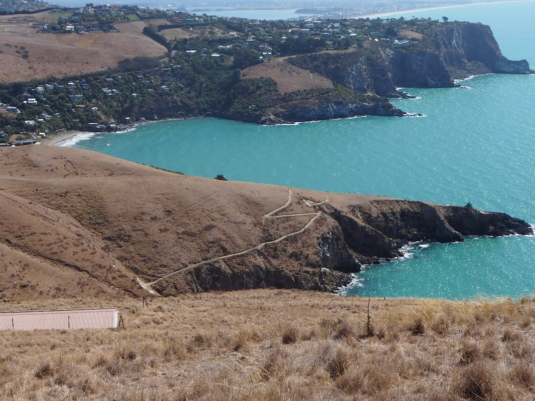
This is a lovely walk - one of our favourites. A long loop walk, through open countryside, with spectacular views, that offers a good workoput without ever being tough, it has almost everything one could want. It's on-leash for dogs, which may seem a shame, but the walk is across farming country and there are sheep around - and for much of the walk there are also steep slopes and cliffs where it feels a lot safer to have the dogs under direct control. In addition, the coastal section of the path is a popular jogging track, so there are likely to be be other, faster people around.who want to squeeze past now and then. 

The opportunities for walks that take in Godley Head are considerable, for the area is part of the Crater Rim walkway, which runs for 25 km or more around the Port Hills. The short and simple version is an 8-9 km loop which includes the World War 2 gun emplacements on the headland, the beach at Taylors Mistake and a section of the ridgeline of the Port Hills. This can conveniently be started at any of the carparks - in Taylors Mistake, on Evans Pass, or at Godley Head itself.

One of the best ways to do it is clockwise, starting at Taylors Mistake. From the information board on the south side of the carpark (or equally from the beach), the path passes an iconic row of simple baches before ascending gradually as it follows the coastal path up onto Godley Head. On the way, there are great views across to the east coast beyond Christchurch, as well as  interesting glimpses of the volcanic geology of the area in the bays and headlands below. There are also some information boards about the history and settlement of the Port Hills, and the opportunity to drop down into Boulder Bay as a diversion. After thirty minutes or so, the path ascends more steadily and on roughly the one hour mark comes out amid the concrete buttresses and plinths of the gun emplacements on the Head.
From there, the main gravel path leads somewhat unexpectedly southwards and down, on the Lyttleton side of the ridge, where it visits some more gunnery stations before looping back up to the Godley Head carpark. For a shorter alternative, you can take a narrow and grassy path from a gate amidst the pine trees on the western side of the camp area, which leads across the meadows and, with a quick hop across a wooden fenceline, takes you to the carpark just the same. After that, you again have a choice of paths you can follow - the shared footpath over the summit, or one of the two mountain bike tracks that run either side of the Summit Road. The choice doesn't matter much because they all converge on the next carpark along Summit Road, where you cross the road and then follow another series of bifurcating paths back down the north side of the Port Hills into Taylors Mistake. Alternatively, you can continue westwards to Evans Pass - another couple of kilometres or so - and take the track between the two roads, which curls its way back to the start.

  ​​
Picture
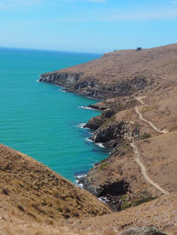
The Godley Head walkway

Including time to wander around the gun emplacements and admire the views, the whole loop should take asnything from 2 to 4 hours, but because of the range of patths available, you can easily make the walk longer or shorter according to wish. To extend the walk - and add a bit of challenge - you can also start it from the sea front in Sumner and take the Flowers Track and Taylors Mistake Track over the headland into Taylors Mistake. Whatever you choose, I can guarantee that both you and the dogs will enjoy it, and want to come back. Note, though, that from the carpark at Taylors Mistake onwards there's not really any water available en route (one useful but not always clean cattle-trough near the grassy path on Godley Head) - so it's sensible to take some water along for the dogs.

Click on the map to zoom
To download details of this site as a pdf, click here
If you've found this website helpful, you might also want to look at some of my novels and poetry. These, like my dog-walking, are drawn from a love of nature and the countryside. To learn more, click here.