And the dog came too... dog walks in New Zealand
  • Home
  • Introduction
  • Notes for Users
  • Alarums and Excursions!!
  • South Island
    • North-West >
      • Atua Stream Walk
      • Barnicoat
      • Ben Nevis
      • Botanical Hill
      • Boulder Bank
      • Brooklyn
      • Collingwood Beach
      • Collingwood Cemetery
      • Cotterell Road
      • Dellside
      • Dicker Road
      • Dominion Flats
      • Eves Valley Road
      • Faulkner Bush
      • Grampians
      • Great Taste Trail - Richmond
      • Great Taste Trail - Kohatu
      • Great Taste Trail - Wakefield
      • Hacket Valley
      • Hoddy Estuary Reserve
      • Hoddy Road
      • Kawatiri Rail Tunnel walk
      • Kina Beach
      • Maitai Valley
      • Mapua Headland
      • Marahau Beach
      • Marahau Forest
      • Mead Stream
      • Milnthorpe Forest
      • Motueka Inlet
      • Motueka Spit
      • Pakawau Beach
      • Paton's Rock
      • Paynes Ford Tramline Track
      • Pearse Valley
      • Pohara Beach
      • Rameka Creek
      • Red Hills
      • Ridgeview Road Walkway
      • Robson Reserve
      • Rough Island
      • Sharlands
      • Split Apple Rock
      • Stagecoach Road
      • St Arnaud Loop Walk
      • Tahunanui Beach
      • Tantragee
      • Tasman View Road
      • Teetotal
      • Two Rivers
      • Waimea Fish-Out Ponds
      • Waimea River Trail
      • Wairoa River Left Branch
      • Waiwhero Forest
      • Waiwhero Ridge
    • North-East >
      • Archer's Track
      • Blairich Reserve
      • Cullen Creek
      • Cullen Point
      • Davies Bay Track
      • Esson's Valley Tracks
      • Goulter River
      • Grovetown Lagoon
      • Half Moon Track
      • Kotuku Trail
      • Lake Chalice
      • Link Trail East
      • Link Trail West
      • Lower Wairau
      • Mount Baldy and Mount Royal
      • Mount Barrett Walkway
      • Mount Fell
      • Mount Fishtail
      • Mount Richmond
      • Mount Riley
      • Mount Robertson
      • Mount Stokes
      • Mount Takorika
      • Ngakuta Bay
      • Nydia Track
      • Opouri Bridle Track
      • Patutu Walk
      • Pelorus Track
      • Piwakawa Track
      • Rarangi
      • Sawcut Gorge
      • Snout Tracks
      • Taylor's Valley
      • Tirohanga
      • Wairau River
      • Wakamarina Track
    • West >
      • Alborns Track
      • Big Rimu Tree walk
      • Charming Creek
      • Chasm Creek
      • Coalbrookdale
      • Denniston Historic Walkway
      • Denniston Plateau
      • Gentle Annie Point walk
      • Goldsborough Tracks
      • Haast-Paringa Cattle Track
      • Kawatiri Beach Trail
      • Kawatiri River Trail
      • Kumara Community walks
      • Lake Hanlon
      • Larry's Creek
      • Mikonui River
      • Millerton Bathhouse Track
      • Moeraki Valley Track
      • Mokihinui Stopbank
      • Mount Adams
      • Mount Glasgow
      • Mount Haast Route
      • Murchison Tree Walks
      • Murray Creek
      • Old Ghost Road
      • Porika Road
      • Powerhouse and Lookout Walks
      • Progress Water Race
      • Ross Goldfield Walks
      • Skyline Walk
      • Stafford Bay Loop
      • Wanganui River
      • Whataroa Walks
      • Whitcombe Loop Tracks
      • Whitcombe Valley Track
      • Zig-Zag Track
    • Central-North >
      • Balmoral Lookout
      • Bottle Lake
      • Cheviot Hills Reserve
      • Childrens Bay Farm
      • Craigieburn Forest
      • Culverden Domain
      • Diamond Harbour
      • Ellangowan Scenic Reserve
      • Garden of Tane
      • Godley Head
      • Governors Bay
      • Halswell Quarry
      • Hanmer Forest Walks
      • H W Hart Arboretum
      • Ka Whata Tu o Rakihouia
      • Kaikoura Trail
      • Kowai Bush Reserve
      • Kowai River
      • Lyttleton Coastal Walk
      • Lytteleton Hills
      • McCleans Forest
      • McHughs Forest Park
      • Mears Bush
      • Mount Grey
      • Mount Oxford
      • Mount Richardson
      • Mount Thomas
      • Newton Falls
      • Ngaio Point
      • Panama Rock
      • Pegasus Bay
      • Rakahuri River
      • Sign of the Bellbird
      • Sign of the Kiwi
      • St James Conservation Park
      • Tutakakahikura Scenic Reserve​
      • Victoria Park
      • West Melton Forest
      • Woodills North
      • Woodills South
    • Central-South >
      • Ahuriri East Branch
      • Ahuriri Valley Tracks
      • Ashburton River
      • Benmore Peninsula
      • Centennial Park
      • Cowan's Hill
      • Dingle Burn
      • Double Hill
      • Freehold Creek
      • Greta and Dorcy Tracks
      • Gunns Bush
      • Hook Bush
      • Huxley and Hopkins Valleys
      • Kelceys Bush
      • Knottingly Park
      • Lake Emma walk
      • Lake Emily Tracks
      • Lake Hood
      • Lake Ohau Track
      • Lake Opuha Walk
      • Lake Tekapo Lakeside Walk
      • Lake Tekapo Regional Park
      • Lake Wainono
      • Lower Opihi River Track
      • Macaulay River walk
      • Methven walkway
      • Mount Barrosa
      • Mount Sunday & Mount Potts
      • Opihi River Walkway
      • Orari River Mountain Bike Tracks
      • Pareora River
      • Pioneer Park
      • Potts River Walks
      • Quailburn Track
      • Saltwater Creek
      • Snowy Gorge
      • Talbot Forest
      • Temple Valley Tracks
      • Waihao River
      • Waihi River Walk
      • Waimate Creek walks
      • Waitohi Bush
    • South-East >
      • Alexandra Anniversary Walk
      • Arawata Bridle Track
      • Arrow Gorge Loop
      • Arrowtown Millennium Track
      • Bannockburn Sluicings
      • Bob's Cove and Twelve Mile Delta
      • Boundary Creek
      • Bull Creek
      • Bullendale Track
      • Butcher's Dam
      • Central Otago Rail Trail
      • Chrystals Beach
      • Clutha Riverside Track
      • Commissioner's Track
      • Conroy's Dam
      • Cromwell-Pisa Walkway
      • Crystal Battery
      • Deans Bank Track
      • Diamond Creek Track
      • Dunedin Walks
      • Earnscleugh Tailings
      • Flagstaff Hill
      • Frankton Arm Walkway
      • Gabriel's Gully
      • Gibbston River Trail
      • Gladstone Track
      • Glendhu Bay Track
      • Glenorchy Boardwalk
      • Grovers Hill
      • Hawea River Track
      • Huriawa Pa Walk
      • Kanuka Loop
      • Lake Alta Track
      • Lake Hayes Trail
      • Lakeside Walk
      • Leith Saddle
      • Long Beach
      • Mapoutahi
      • Mosgiel Floodbank
      • Mount Cargill
      • Mount Crichton Loop
      • Mount Iron Track
      • Munro's Gully
      • Naseby Forest
      • Nevis Valley Tracks
      • Newcastle Track
      • One MIle Creek
      • Oteake Conservation Park
      • Outram Glen
      • Quartz Reef
      • St Bathans
      • Trotters Gorge
    • South-West >
      • Blair Athol Walkway
      • Boyd Creek
      • Manapouri cycleway
      • McLean Falls
      • The Bluff
  • North Island
    • Auckland & Waiheke
    • Coromandel & North Waikato
    • Wellington
    • The North
    • Manawatu & Wairarapa
    • The East
    • Taranaki & Central
  • Useful Links
  • Progress Water Race
  • Rock and Pillar Conservation Park
  • New Page
  • New Page
  • New Page
  • New Page
  • New Page
  • New Page

Diamond Harbour

A varied but sometimes challenging cliff-walk on the edge of The Harbour.

Button Text

Diamond Harbour
​

Though geographic neighbours, and similar in terms of landscape and geological origin, Port Hills and Banks Peninsula are worlds apart. The former is relatively easy to access and boasts an extensive network of good, dog-friendly walks. The latter is much harder to get at - and when you manage to do so, it is a constant frustration because of the limitations on where you can take your dog.

Diamond Harbour sits between the two. Though technically on Banks Peninsula, it seems to 'belong' to the Port Hills. It nestles on the edge of Lyttleton Harbour and stares at Lyttleton itself, only a kilometre or so away across the water, while being more-or-less cut off from Akaroa and the rest of Banks Peninsula to the south. And yet, in terms of dog-walking, it just doesn't quite come up to the hills to the north. Though there are a number of rewarding walks in the area - notably the route up Mount Herbert - the majority are off limits to dogs, and even the few good beaches on oiffer are non-dog for much of the year. 

The one dog-friendly walk of any length is the Head-to-Head walk. (Note that this is one of three Head-to-Head walks around Lyttleton Harbour; presumably the intention, one day, will be link them all up!)  This runs from Hays Bay in the north-west to Purau beach in the south-east. For a full walk, it's probably best to start at Hays Bay and walk east. For a slightly shorter walk you can also join the walk ifrom Black Rock Road a little tothe north, but to do so you have to brave a daunting forest of private road signs on the headland, which seems to have been taken over as one of those dreadful gated communities. Another option is to access the walk from Stoddart Point Reserve in Diamond Harbour, more-or-less in the centre of the walkway.
​

Picture
Name
Diamond Harbour
Location
Port Hills
Co-ordinates
1576779  5168678
Alternative co-ordinates
1576779  5168678
Configuration
Loop
Distance
8 km
Status
Varied
Grade
Easy
Access
Various access points including: 1) Hays Bay, off Marine Drive about 1 km west of Diamond Bay; 2) Carpark on Stoddart Point.
Description
A long and pleasant coastal walk, with views into Diamond Harbour and varied stretches of bush and country lane, and offering as range of  loop options.Take care on the short stretch along Purua Avenue at the south-eastern end of the walk.
Connecting tracks
 
Further information
https://www.ccc.govt.nz/assets/Documents/Parks-Gardens/Explore-Parks/Port-Hills-A2-Walking-Tracks.pdf
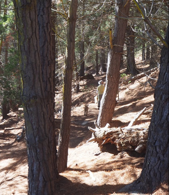
For the most part the walk is pleasant and not too demanding, with a varied terrain of rocky headland, pine forest and sandy beach. The views towards Lyttleton are good, and to whet your appetite to head over there, you pass the jetty from which the small Lyttleton ferry leaves. On Stoddart Point there are some shady picnic spots, and a cafe/bar is nearby. As you continue on around the headland, however, the track becomes narrow and in places has an uncomfortable cross-slope that means you need to be reasonably sure of foot. Some of the signage is also annoyingly ambiguous, so it can be easy to miss your way. It's worth bearing in mind, as well, that the final section down to Purau is on a narriow verge by the road. When you see the side-path signed to Purau Avenue you might therefore be tempted to cut the walk short and head back up into Diamond Harbour. Be warned, though: it's a short and rather precipitous scramble up to the road - and I definitely wouldn't advise this as a way of joining the path from above.
To make the walk into a round trip, from Purau you can take Waituturi Lane and the Old Stock Road up to join Bay View Road - a small, gravel track - and then follow that back to the start at Hays Bay. There are also several options to walk down through Diamond harbour to the southern end of Stoddart Point (see map below). 

Whatever route you choose, this is a worthwhile walk but it has its hazards - so take care!
If you've found this website helpful, you might also want to look at some of my novels and poetry. These, like my dog-walking, are drawn from a love of nature and the countryside. To learn more, click here.