And the dog came too... dog walks in New Zealand
  • Home
  • Introduction
  • Notes for Users
  • Alarums and Excursions!!
  • South Island
    • North-West >
      • Atua Stream Walk
      • Barnicoat
      • Ben Nevis
      • Botanical Hill
      • Boulder Bank
      • Brooklyn
      • Collingwood Beach
      • Collingwood Cemetery
      • Cotterell Road
      • Dellside
      • Dicker Road
      • Dominion Flats
      • Eves Valley Road
      • Faulkner Bush
      • Grampians
      • Great Taste Trail - Richmond
      • Great Taste Trail - Kohatu
      • Great Taste Trail - Wakefield
      • Hacket Valley
      • Hoddy Estuary Reserve
      • Hoddy Road
      • Kawatiri Rail Tunnel walk
      • Kina Beach
      • Maitai Valley
      • Mapua Headland
      • Marahau Beach
      • Marahau Forest
      • Mead Stream
      • Milnthorpe Forest
      • Motueka Inlet
      • Motueka Spit
      • Pakawau Beach
      • Paton's Rock
      • Paynes Ford Tramline Track
      • Pearse Valley
      • Pohara Beach
      • Rameka Creek
      • Red Hills
      • Ridgeview Road Walkway
      • Robson Reserve
      • Rough Island
      • Sharlands
      • Split Apple Rock
      • Stagecoach Road
      • St Arnaud Loop Walk
      • Tahunanui Beach
      • Tantragee
      • Tasman View Road
      • Teetotal
      • Two Rivers
      • Waimea Fish-Out Ponds
      • Waimea River Trail
      • Wairoa River Left Branch
      • Waiwhero Forest
      • Waiwhero Ridge
    • North-East >
      • Archer's Track
      • Blairich Reserve
      • Cullen Creek
      • Cullen Point
      • Davies Bay Track
      • Esson's Valley Tracks
      • Goulter River
      • Grovetown Lagoon
      • Half Moon Track
      • Kotuku Trail
      • Lake Chalice
      • Link Trail East
      • Link Trail West
      • Lower Wairau
      • Mount Baldy and Mount Royal
      • Mount Barrett Walkway
      • Mount Fell
      • Mount Fishtail
      • Mount Richmond
      • Mount Riley
      • Mount Robertson
      • Mount Stokes
      • Mount Takorika
      • Ngakuta Bay
      • Nydia Track
      • Opouri Bridle Track
      • Patutu Walk
      • Pelorus Track
      • Piwakawa Track
      • Rarangi
      • Sawcut Gorge
      • Snout Tracks
      • Taylor's Valley
      • Tirohanga
      • Wairau River
      • Wakamarina Track
    • West >
      • Alborns Track
      • Big Rimu Tree walk
      • Charming Creek
      • Chasm Creek
      • Coalbrookdale
      • Denniston Historic Walkway
      • Denniston Plateau
      • Gentle Annie Point walk
      • Goldsborough Tracks
      • Haast-Paringa Cattle Track
      • Kawatiri Beach Trail
      • Kawatiri River Trail
      • Kumara Community walks
      • Lake Hanlon
      • Larry's Creek
      • Mikonui River
      • Millerton Bathhouse Track
      • Moeraki Valley Track
      • Mokihinui Stopbank
      • Mount Adams
      • Mount Glasgow
      • Mount Haast Route
      • Murchison Tree Walks
      • Murray Creek
      • Old Ghost Road
      • Porika Road
      • Powerhouse and Lookout Walks
      • Progress Water Race
      • Ross Goldfield Walks
      • Skyline Walk
      • Stafford Bay Loop
      • Wanganui River
      • Whataroa Walks
      • Whitcombe Loop Tracks
      • Whitcombe Valley Track
      • Zig-Zag Track
    • Central-North >
      • Balmoral Lookout
      • Bottle Lake
      • Cheviot Hills Reserve
      • Childrens Bay Farm
      • Craigieburn Forest
      • Culverden Domain
      • Diamond Harbour
      • Ellangowan Scenic Reserve
      • Garden of Tane
      • Godley Head
      • Governors Bay
      • Halswell Quarry
      • Hanmer Forest Walks
      • H W Hart Arboretum
      • Ka Whata Tu o Rakihouia
      • Kaikoura Trail
      • Kowai Bush Reserve
      • Kowai River
      • Lyttleton Coastal Walk
      • Lytteleton Hills
      • McCleans Forest
      • McHughs Forest Park
      • Mears Bush
      • Mount Grey
      • Mount Oxford
      • Mount Richardson
      • Mount Thomas
      • Newton Falls
      • Ngaio Point
      • Panama Rock
      • Pegasus Bay
      • Rakahuri River
      • Sign of the Bellbird
      • Sign of the Kiwi
      • St James Conservation Park
      • Tutakakahikura Scenic Reserve​
      • Victoria Park
      • West Melton Forest
      • Woodills North
      • Woodills South
    • Central-South >
      • Ahuriri East Branch
      • Ahuriri Valley Tracks
      • Ashburton River
      • Benmore Peninsula
      • Centennial Park
      • Cowan's Hill
      • Dingle Burn
      • Double Hill
      • Freehold Creek
      • Greta and Dorcy Tracks
      • Gunns Bush
      • Hook Bush
      • Huxley and Hopkins Valleys
      • Kelceys Bush
      • Knottingly Park
      • Lake Emma walk
      • Lake Emily Tracks
      • Lake Hood
      • Lake Ohau Track
      • Lake Opuha Walk
      • Lake Tekapo Lakeside Walk
      • Lake Tekapo Regional Park
      • Lake Wainono
      • Lower Opihi River Track
      • Macaulay River walk
      • Methven walkway
      • Mount Barrosa
      • Mount Sunday & Mount Potts
      • Opihi River Walkway
      • Orari River Mountain Bike Tracks
      • Pareora River
      • Pioneer Park
      • Potts River Walks
      • Quailburn Track
      • Saltwater Creek
      • Snowy Gorge
      • Talbot Forest
      • Temple Valley Tracks
      • Waihao River
      • Waihi River Walk
      • Waimate Creek walks
      • Waitohi Bush
    • South-East >
      • Alexandra Anniversary Walk
      • Arawata Bridle Track
      • Arrow Gorge Loop
      • Arrowtown Millennium Track
      • Bannockburn Sluicings
      • Bob's Cove and Twelve Mile Delta
      • Boundary Creek
      • Bull Creek
      • Bullendale Track
      • Butcher's Dam
      • Central Otago Rail Trail
      • Chrystals Beach
      • Clutha Riverside Track
      • Commissioner's Track
      • Conroy's Dam
      • Cromwell-Pisa Walkway
      • Crystal Battery
      • Deans Bank Track
      • Diamond Creek Track
      • Dunedin Walks
      • Earnscleugh Tailings
      • Flagstaff Hill
      • Frankton Arm Walkway
      • Gabriel's Gully
      • Gibbston River Trail
      • Gladstone Track
      • Glendhu Bay Track
      • Glenorchy Boardwalk
      • Grovers Hill
      • Hawea River Track
      • Huriawa Pa Walk
      • Kanuka Loop
      • Lake Alta Track
      • Lake Hayes Trail
      • Lakeside Walk
      • Leith Saddle
      • Long Beach
      • Mapoutahi
      • Mosgiel Floodbank
      • Mount Cargill
      • Mount Crichton Loop
      • Mount Iron Track
      • Munro's Gully
      • Naseby Forest
      • Nevis Valley Tracks
      • Newcastle Track
      • One MIle Creek
      • Oteake Conservation Park
      • Outram Glen
      • Quartz Reef
      • St Bathans
      • Trotters Gorge
    • South-West >
      • Blair Athol Walkway
      • Boyd Creek
      • Manapouri cycleway
      • McLean Falls
      • The Bluff
  • North Island
    • Auckland & Waiheke
    • Coromandel & North Waikato
    • Wellington
    • The North
    • Manawatu & Wairarapa
    • The East
    • Taranaki & Central
  • Useful Links
  • Progress Water Race
  • Rock and Pillar Conservation Park
  • New Page
  • New Page
  • New Page
  • New Page
  • New Page
  • New Page

Governors Bay

An interesting coastal walk that's more strenuous than it looks, or a network of tracks through bushland on the flanks of the Port Hills.

Back to Regional Map

Governors Bay
​

Name
Governors Bay
Location
Governors Bay
Co-ordinates
1571487  5170072
Alternative co-ordinates
1571658  5168066
Configuration
Network
Distance
10 km
Status
Mainly on-leash
Grade
Easy-Severe
Access
Take Governors Bay Road to the settlement of Governors Bay. Walks can be accessed at various points along the road - e.g. at Allendale Reserve, Jetty Road or Sandy Bay Road (for the coastal path) or from Zephyr Terrace or Ernst Adams Drive (to walks in Ohinetahi Reserve). 
Description
A choice of a gentle coastal walk or a series of tough climbs up the inner flanks of the Port Hills 
Connecting tracks
Includes Ohinetahi Reserve and Coastal Path; links to Crater Rim (e.g. at Sign of the Bellbird)
Further information
https://www.ccc.govt.nz/assets/Documents/Parks-Gardens/Explore-Parks/Port-Hills-A2-Walking-Tracks.pdf

https://www.summitroadsociety.org.nz/wordpress/wp-content/uploads/2016/09/OhinetahiTracks.pdf​
Click on the map to zoom
Tracks in Ohinetahi Reserve
Picture
Set at the western end of the Harbour, as the big inlet that divides the Port Hills from Banks Peninsula is colluquially known, Governors Bay is a good base for walks in this area. The extensive network of walks along the Crater Rim are only a few minutes drive away via Dyers Pass Road, and Lyttleton is also handy. In addition, there's a range of good walks on the doorstep, suitable for just about every taste. ​
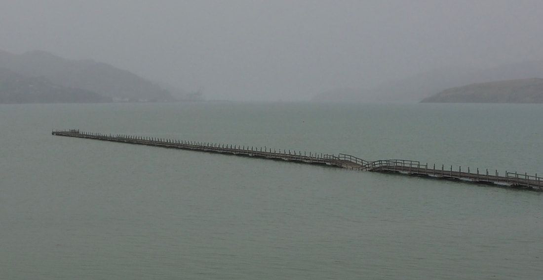
For a shortish (up to 2 hours one way) walk, the Head-to-Head walkway is a good option. In its entirety, this runs from Allendale Reserve in the south to Maori Gardens in the north - a distance of about 4 km. In the south, access is possible from the carpark at Allendale Reserve. From here, the path follows an old coach road along the shoreline, on the way taking in several sites of local significance. Look out, in particular, for the stately Ohinetahi Homestead, where the path curves east, and later on the fascinating (not to say beautiful) features in the volcanic rocks, known on local maps as the Volcanic Caverns. As you pass the sewerage station and approach the jetty, the track becomes somewhat more functional but rounding a rocky headland you soon catch sight of the jetty, with its sad sag half-way along. While you might imagine that this was a consequence of the Christchurch earthquake, you'd only be partly right. The damage became evident then, but its origins are much older and are due to the deterioration of the supporting piles over many decades. The jetty has been an important feature in the community, however, so unsurprisingly there's now an active campaign to raise money for kits restoration. 

​North of the jetty the path becomes less formed as it winds its way through trees anmd scrubland just above the high-water mark, occasionally dipping down onto the beach, until it crosses Sandy Beach Road. The beach itself is out of bounds to dogs during summer months, but is supposedly a good swimming spot, tbough beyond its fringe of sand it looks somewhat muddy and inviting at low tide. The track, now, becomes broader again, and runs above the beach, before climbing onto the next headland. After a short, low cliff section, there's a path off to the right which goes down onto the foreshore, and if you are at all geologically mninded is worth a deviatioin when the tide is right to see some good examplef of volcanicic dikes. (Dikes are vertical veins of rock that radiate outwards from volcanoes. They are formed when hot magma, instead of bubbling to the surface, forces its way along li nes of weakness into the surrounding rocks.)

The main track, meanwhile, continues to climb onto higher and rather precipitous cliffs. At this point, the local walking guide advises you to take the right hand path that runs down past a becnh beneath a pine tree to the beach, in order to reach Maori Gardens. I wouldn't advise it, however, because the bank at the base of the steps has been badly eroded: sliding down might be easy; getting back up may be more of a challenge. Alternatively, you can follow the man path upwards for another 100 metres or so to its end - where it comes out onto Governors Bay Road. As you do so, you may wonder where the gardens are. A good question.  Maybe there were kumara beds here once, but there are no signs of them now. Today, the word is just a name. But even with that disappointment, it's a pleasant and often charming walk, that offers enough physical challenge to make it worthwhile. Be warned, however, that Governers Bay Road is busy and lacks a footpath - and does not offer a very safe return route. So the best way home is probably back the way you came.  

If you want a longer walk, and more physical challenge, you can head up the track beside Dyers Pass Road, and join the Crater Rim walkway at the Sign of the Kiwi, from where there's an extensive network of routes. Alternatively, you can stay more local and walk in Ohinetahi Reserve (see map, below right). This contains 10 km or more of tracks running through remnant and secondary native bush, on the steep hillslope between Governors Bay and the Crater Rim. For a longish loop walk, take Faulkners Track from The Terrace to the ridgeline in Hoons Hay Reserve, then turn south along the Crater Rim walkway and return via one of the several tracks down onto Ngaio Track to Bay Heights and the coast. (Note that on some information leaflets this is shown as non-dog, but both the signs on the ground and the Summit Road Society website classify the area as on-leash.) If that's all too daunting for you, it's possible to shorten the route, and omit the steeper sections, by taking the South Boundary Track half-way along Faulkners Track and then return via Titoki Track.
Picture
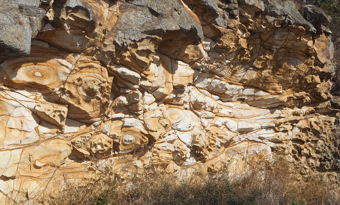
Above: Weathered volcanic rocks on the Head to Head walkway. 
​
Left: The jetty at Governors Bay
If you've found this website helpful, you might also want to look at some of my novels and poetry. These, like my dog-walking, are drawn from a love of nature and the countryside. To learn more, click here.