And the dog came too... dog walks in New Zealand
  • Home
  • Introduction
  • Notes for Users
  • Alarums and Excursions!!
  • South Island
    • North-West >
      • Atua Stream Walk
      • Barnicoat
      • Ben Nevis
      • Botanical Hill
      • Boulder Bank
      • Brooklyn
      • Collingwood Beach
      • Collingwood Cemetery
      • Cotterell Road
      • Dellside
      • Dicker Road
      • Dominion Flats
      • Eves Valley Road
      • Faulkner Bush
      • Grampians
      • Great Taste Trail - Richmond
      • Great Taste Trail - Kohatu
      • Great Taste Trail - Wakefield
      • Hacket Valley
      • Hoddy Estuary Reserve
      • Hoddy Road
      • Kawatiri Rail Tunnel walk
      • Kina Beach
      • Maitai Valley
      • Mapua Headland
      • Marahau Beach
      • Marahau Forest
      • Mead Stream
      • Milnthorpe Forest
      • Motueka Inlet
      • Motueka Spit
      • Pakawau Beach
      • Paton's Rock
      • Paynes Ford Tramline Track
      • Pearse Valley
      • Pohara Beach
      • Rameka Creek
      • Red Hills
      • Ridgeview Road Walkway
      • Robson Reserve
      • Rough Island
      • Sharlands
      • Split Apple Rock
      • Stagecoach Road
      • St Arnaud Loop Walk
      • Tahunanui Beach
      • Tantragee
      • Tasman View Road
      • Teetotal
      • Two Rivers
      • Waimea Fish-Out Ponds
      • Waimea River Trail
      • Wairoa River Left Branch
      • Waiwhero Forest
      • Waiwhero Ridge
    • North-East >
      • Archer's Track
      • Blairich Reserve
      • Cullen Creek
      • Cullen Point
      • Davies Bay Track
      • Esson's Valley Tracks
      • Goulter River
      • Grovetown Lagoon
      • Half Moon Track
      • Kotuku Trail
      • Lake Chalice
      • Link Trail East
      • Link Trail West
      • Lower Wairau
      • Mount Baldy and Mount Royal
      • Mount Barrett Walkway
      • Mount Fell
      • Mount Fishtail
      • Mount Richmond
      • Mount Riley
      • Mount Robertson
      • Mount Stokes
      • Mount Takorika
      • Ngakuta Bay
      • Nydia Track
      • Opouri Bridle Track
      • Patutu Walk
      • Pelorus Track
      • Piwakawa Track
      • Rarangi
      • Sawcut Gorge
      • Snout Tracks
      • Taylor's Valley
      • Tirohanga
      • Wairau River
      • Wakamarina Track
    • West >
      • Alborns Track
      • Big Rimu Tree walk
      • Charming Creek
      • Chasm Creek
      • Coalbrookdale
      • Denniston Historic Walkway
      • Denniston Plateau
      • Gentle Annie Point walk
      • Goldsborough Tracks
      • Haast-Paringa Cattle Track
      • Kawatiri Beach Trail
      • Kawatiri River Trail
      • Kumara Community walks
      • Lake Hanlon
      • Larry's Creek
      • Mikonui River
      • Millerton Bathhouse Track
      • Moeraki Valley Track
      • Mokihinui Stopbank
      • Mount Adams
      • Mount Glasgow
      • Mount Haast Route
      • Murchison Tree Walks
      • Murray Creek
      • Old Ghost Road
      • Porika Road
      • Powerhouse and Lookout Walks
      • Progress Water Race
      • Ross Goldfield Walks
      • Skyline Walk
      • Stafford Bay Loop
      • Wanganui River
      • Whataroa Walks
      • Whitcombe Loop Tracks
      • Whitcombe Valley Track
      • Zig-Zag Track
    • Central-North >
      • Balmoral Lookout
      • Bottle Lake
      • Cheviot Hills Reserve
      • Childrens Bay Farm
      • Craigieburn Forest
      • Culverden Domain
      • Diamond Harbour
      • Ellangowan Scenic Reserve
      • Garden of Tane
      • Godley Head
      • Governors Bay
      • Halswell Quarry
      • Hanmer Forest Walks
      • H W Hart Arboretum
      • Ka Whata Tu o Rakihouia
      • Kaikoura Trail
      • Kowai Bush Reserve
      • Kowai River
      • Lyttleton Coastal Walk
      • Lytteleton Hills
      • McCleans Forest
      • McHughs Forest Park
      • Mears Bush
      • Mount Grey
      • Mount Oxford
      • Mount Richardson
      • Mount Thomas
      • Newton Falls
      • Ngaio Point
      • Panama Rock
      • Pegasus Bay
      • Rakahuri River
      • Sign of the Bellbird
      • Sign of the Kiwi
      • St James Conservation Park
      • Tutakakahikura Scenic Reserve​
      • Victoria Park
      • West Melton Forest
      • Woodills North
      • Woodills South
    • Central-South >
      • Ahuriri East Branch
      • Ahuriri Valley Tracks
      • Ashburton River
      • Benmore Peninsula
      • Centennial Park
      • Cowan's Hill
      • Dingle Burn
      • Double Hill
      • Freehold Creek
      • Greta and Dorcy Tracks
      • Gunns Bush
      • Hook Bush
      • Huxley and Hopkins Valleys
      • Kelceys Bush
      • Knottingly Park
      • Lake Emma walk
      • Lake Emily Tracks
      • Lake Hood
      • Lake Ohau Track
      • Lake Opuha Walk
      • Lake Tekapo Lakeside Walk
      • Lake Tekapo Regional Park
      • Lake Wainono
      • Lower Opihi River Track
      • Macaulay River walk
      • Methven walkway
      • Mount Barrosa
      • Mount Sunday & Mount Potts
      • Opihi River Walkway
      • Orari River Mountain Bike Tracks
      • Pareora River
      • Pioneer Park
      • Potts River Walks
      • Quailburn Track
      • Saltwater Creek
      • Snowy Gorge
      • Talbot Forest
      • Temple Valley Tracks
      • Waihao River
      • Waihi River Walk
      • Waimate Creek walks
      • Waitohi Bush
    • South-East >
      • Alexandra Anniversary Walk
      • Arawata Bridle Track
      • Arrow Gorge Loop
      • Arrowtown Millennium Track
      • Bannockburn Sluicings
      • Bob's Cove and Twelve Mile Delta
      • Boundary Creek
      • Bull Creek
      • Bullendale Track
      • Butcher's Dam
      • Central Otago Rail Trail
      • Chrystals Beach
      • Clutha Riverside Track
      • Commissioner's Track
      • Conroy's Dam
      • Cromwell-Pisa Walkway
      • Crystal Battery
      • Deans Bank Track
      • Diamond Creek Track
      • Dunedin Walks
      • Earnscleugh Tailings
      • Flagstaff Hill
      • Frankton Arm Walkway
      • Gabriel's Gully
      • Gibbston River Trail
      • Gladstone Track
      • Glendhu Bay Track
      • Glenorchy Boardwalk
      • Grovers Hill
      • Hawea River Track
      • Huriawa Pa Walk
      • Kanuka Loop
      • Lake Alta Track
      • Lake Hayes Trail
      • Lakeside Walk
      • Leith Saddle
      • Long Beach
      • Mapoutahi
      • Mosgiel Floodbank
      • Mount Cargill
      • Mount Crichton Loop
      • Mount Iron Track
      • Munro's Gully
      • Naseby Forest
      • Nevis Valley Tracks
      • Newcastle Track
      • One MIle Creek
      • Oteake Conservation Park
      • Outram Glen
      • Quartz Reef
      • St Bathans
      • Trotters Gorge
    • South-West >
      • Blair Athol Walkway
      • Boyd Creek
      • Manapouri cycleway
      • McLean Falls
      • The Bluff
  • North Island
    • Auckland & Waiheke
    • Coromandel & North Waikato
    • Wellington
    • The North
    • Manawatu & Wairarapa
    • The East
    • Taranaki & Central
  • Useful Links
  • Progress Water Race
  • Rock and Pillar Conservation Park
  • New Page
  • New Page
  • New Page
  • New Page
  • New Page
  • New Page

Charming Creek

A fascinating and rewarding walk to an old coal mine, nestled in a verdant valley in the western ranges.

Back to Regional Map

Charming Creek​

Name
Charming Creek
Location
Seddonville
Co-ordinates
1512932  5395614
Alternative co-ordinates
 
Configuration
Linear
Distance
4.5 km
Status
Off-leash
Grade
Easy-Moderate
Access
Take Mokihinui-Seddonville Road, ca. 1.5 km after Mokihinui junction, then fork right onto Gladstone Street in Seddonville and continue to the end of Charming Creek Road. Note: saccess to the walk from the southern end is currently closed. 
Description
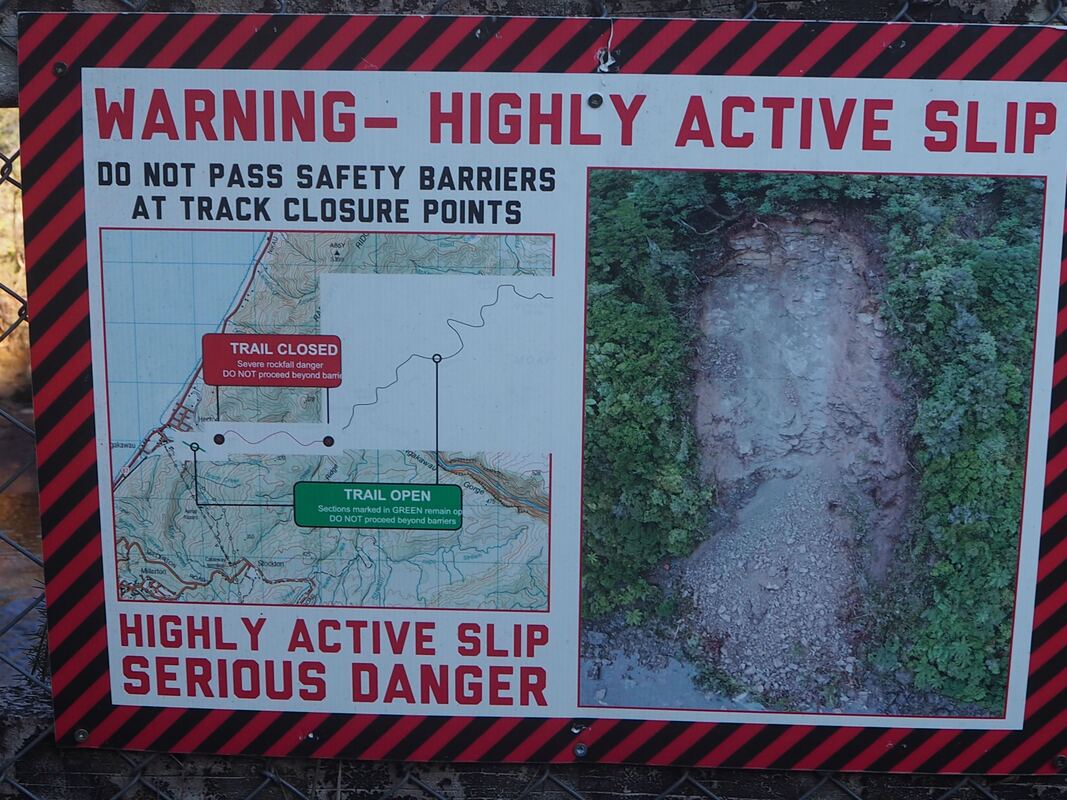
A lovely walk that runs through a mix of vegetation types and scenery, passes lots of old mining relics and offers long stretches of easy walking. Sadly, the southern stretch of this walk was closed due to a major landslp in 2021 and seems unliklely to open in the foreseeable future. Take note of the warning signs!
Connecting tracks
 
Further information
https://www.doc.govt.nz/parks-and-recreation/places-to-go/west-coast/places/charming-creek-area/things-to-do/tracks/charming-creek-walkway/

​

Picture
Picture
Picture
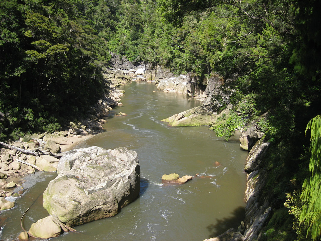
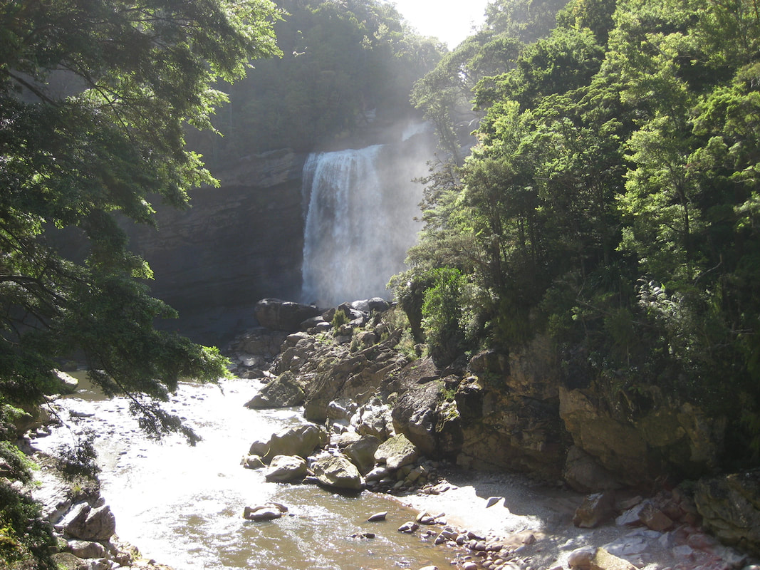
Charming Creek walkway lives up to its name. It is also interesting, a little bit (but not too much) challenging, and very rewarding. The track is of a good standard - well-formed but not over-emgineered. The scenery is varied, with a long gradually rising section through the lower gorge, and an ambling level track beside the water race. There's fascinating history to explore, including the water race itself, old mining equipment, spoil tips, railway lines, tunnels, sawmills and a small suspension bridge. There's also a waterfall and, if you're lucky, in the steepest sections of the gorge, you might catch sight of the rare and protected Celmisia morganii - a daisy-like plant that flowers in December and January and is known only from this locality.

The walk is currently accessible only from the northern end, near Seddonville. Here, you walk through the remains of the old mine workings, where you can briefly divert to look at the sealed-off entrances to the mine. Downslope from there, you passd an assortment of moning gear, includding a  large fan that was originally used to aerate the mine, remains of a bathhouse and old coal bins, not to mention areas of spoil stained by the various minerals that are leaching from the waste. The track then heads downlope, and veers off to the left (watch out for the green post which is all that indicates the junction). After that, there's an up-and-down section past some more mining gear, before the track finds the river and follows a bench through native bush.

For the rest of the allowable way, it's an easy and flat walk for an hour or so along the old railway track until you reach Watson’s Mill. Here, there are old steam boilers rusting in the undergrowth and a shed which contains some photographic displays about the mining. Soon after that - and alerted by the sound of the water - you reach the waterfall and the gorge. There's more interest in the form of the old railway track and the overhanging rocks, and then a short tunnel, before the track reaches a suspension bridge over the  stream, which offers more views of the waterfall and gorge.

Hereabouts, the track is closed, which is a shame, because the next section down the valley is (or was) a lovely stretch of walking. But the landslides that have caused the closure are serious stuff, and the risk of further failures is real. So heed the signs, take one last look down the valley and head back home.
   
Picture
Heading home
Hover on the map to zoom in
If you've found this website helpful, you might also want to look at some of my novels and poetry. These, like my dog-walking, are drawn from a love of nature and the countryside. To learn more, click here.