And the dog came too... dog walks in New Zealand
  • Home
  • Introduction
  • Notes for Users
  • Alarums and Excursions!!
  • South Island
    • North-West >
      • Atua Stream Walk
      • Barnicoat
      • Ben Nevis
      • Botanical Hill
      • Boulder Bank
      • Brooklyn
      • Collingwood Beach
      • Collingwood Cemetery
      • Cotterell Road
      • Dellside
      • Dicker Road
      • Dominion Flats
      • Eves Valley Road
      • Faulkner Bush
      • Grampians
      • Great Taste Trail - Richmond
      • Great Taste Trail - Kohatu
      • Great Taste Trail - Wakefield
      • Hacket Valley
      • Hoddy Estuary Reserve
      • Hoddy Road
      • Kawatiri Rail Tunnel walk
      • Kina Beach
      • Maitai Valley
      • Mapua Headland
      • Marahau Beach
      • Marahau Forest
      • Mead Stream
      • Milnthorpe Forest
      • Motueka Inlet
      • Motueka Spit
      • Pakawau Beach
      • Paton's Rock
      • Paynes Ford Tramline Track
      • Pearse Valley
      • Pohara Beach
      • Rameka Creek
      • Red Hills
      • Ridgeview Road Walkway
      • Robson Reserve
      • Rough Island
      • Sharlands
      • Split Apple Rock
      • Stagecoach Road
      • St Arnaud Loop Walk
      • Tahunanui Beach
      • Tantragee
      • Tasman View Road
      • Teetotal
      • Two Rivers
      • Waimea Fish-Out Ponds
      • Waimea River Trail
      • Wairoa River Left Branch
      • Waiwhero Forest
      • Waiwhero Ridge
    • North-East >
      • Archer's Track
      • Blairich Reserve
      • Cullen Creek
      • Cullen Point
      • Davies Bay Track
      • Esson's Valley Tracks
      • Goulter River
      • Grovetown Lagoon
      • Half Moon Track
      • Kotuku Trail
      • Lake Chalice
      • Link Trail East
      • Link Trail West
      • Lower Wairau
      • Mount Baldy and Mount Royal
      • Mount Barrett Walkway
      • Mount Fell
      • Mount Fishtail
      • Mount Richmond
      • Mount Riley
      • Mount Robertson
      • Mount Stokes
      • Mount Takorika
      • Ngakuta Bay
      • Nydia Track
      • Opouri Bridle Track
      • Patutu Walk
      • Pelorus Track
      • Piwakawa Track
      • Rarangi
      • Sawcut Gorge
      • Snout Tracks
      • Taylor's Valley
      • Tirohanga
      • Wairau River
      • Wakamarina Track
    • West >
      • Alborns Track
      • Big Rimu Tree walk
      • Charming Creek
      • Chasm Creek
      • Coalbrookdale
      • Denniston Historic Walkway
      • Denniston Plateau
      • Gentle Annie Point walk
      • Goldsborough Tracks
      • Haast-Paringa Cattle Track
      • Kawatiri Beach Trail
      • Kawatiri River Trail
      • Kumara Community walks
      • Lake Hanlon
      • Larry's Creek
      • Mikonui River
      • Millerton Bathhouse Track
      • Moeraki Valley Track
      • Mokihinui Stopbank
      • Mount Adams
      • Mount Glasgow
      • Mount Haast Route
      • Murchison Tree Walks
      • Murray Creek
      • Old Ghost Road
      • Porika Road
      • Powerhouse and Lookout Walks
      • Progress Water Race
      • Ross Goldfield Walks
      • Skyline Walk
      • Stafford Bay Loop
      • Wanganui River
      • Whataroa Walks
      • Whitcombe Loop Tracks
      • Whitcombe Valley Track
      • Zig-Zag Track
    • Central-North >
      • Balmoral Lookout
      • Bottle Lake
      • Cheviot Hills Reserve
      • Childrens Bay Farm
      • Craigieburn Forest
      • Culverden Domain
      • Diamond Harbour
      • Ellangowan Scenic Reserve
      • Garden of Tane
      • Godley Head
      • Governors Bay
      • Halswell Quarry
      • Hanmer Forest Walks
      • H W Hart Arboretum
      • Ka Whata Tu o Rakihouia
      • Kaikoura Trail
      • Kowai Bush Reserve
      • Kowai River
      • Lyttleton Coastal Walk
      • Lytteleton Hills
      • McCleans Forest
      • McHughs Forest Park
      • Mears Bush
      • Mount Grey
      • Mount Oxford
      • Mount Richardson
      • Mount Thomas
      • Newton Falls
      • Ngaio Point
      • Panama Rock
      • Pegasus Bay
      • Rakahuri River
      • Sign of the Bellbird
      • Sign of the Kiwi
      • St James Conservation Park
      • Tutakakahikura Scenic Reserve​
      • Victoria Park
      • West Melton Forest
      • Woodills North
      • Woodills South
    • Central-South >
      • Ahuriri East Branch
      • Ahuriri Valley Tracks
      • Ashburton River
      • Benmore Peninsula
      • Centennial Park
      • Cowan's Hill
      • Dingle Burn
      • Double Hill
      • Freehold Creek
      • Greta and Dorcy Tracks
      • Gunns Bush
      • Hook Bush
      • Huxley and Hopkins Valleys
      • Kelceys Bush
      • Knottingly Park
      • Lake Emma walk
      • Lake Emily Tracks
      • Lake Hood
      • Lake Ohau Track
      • Lake Opuha Walk
      • Lake Tekapo Lakeside Walk
      • Lake Tekapo Regional Park
      • Lake Wainono
      • Lower Opihi River Track
      • Macaulay River walk
      • Methven walkway
      • Mount Barrosa
      • Mount Sunday & Mount Potts
      • Opihi River Walkway
      • Orari River Mountain Bike Tracks
      • Pareora River
      • Pioneer Park
      • Potts River Walks
      • Quailburn Track
      • Saltwater Creek
      • Snowy Gorge
      • Talbot Forest
      • Temple Valley Tracks
      • Waihao River
      • Waihi River Walk
      • Waimate Creek walks
      • Waitohi Bush
    • South-East >
      • Alexandra Anniversary Walk
      • Arawata Bridle Track
      • Arrow Gorge Loop
      • Arrowtown Millennium Track
      • Bannockburn Sluicings
      • Bob's Cove and Twelve Mile Delta
      • Boundary Creek
      • Bull Creek
      • Bullendale Track
      • Butcher's Dam
      • Central Otago Rail Trail
      • Chrystals Beach
      • Clutha Riverside Track
      • Commissioner's Track
      • Conroy's Dam
      • Cromwell-Pisa Walkway
      • Crystal Battery
      • Deans Bank Track
      • Diamond Creek Track
      • Dunedin Walks
      • Earnscleugh Tailings
      • Flagstaff Hill
      • Frankton Arm Walkway
      • Gabriel's Gully
      • Gibbston River Trail
      • Gladstone Track
      • Glendhu Bay Track
      • Glenorchy Boardwalk
      • Grovers Hill
      • Hawea River Track
      • Huriawa Pa Walk
      • Kanuka Loop
      • Lake Alta Track
      • Lake Hayes Trail
      • Lakeside Walk
      • Leith Saddle
      • Long Beach
      • Mapoutahi
      • Mosgiel Floodbank
      • Mount Cargill
      • Mount Crichton Loop
      • Mount Iron Track
      • Munro's Gully
      • Naseby Forest
      • Nevis Valley Tracks
      • Newcastle Track
      • One MIle Creek
      • Oteake Conservation Park
      • Outram Glen
      • Quartz Reef
      • St Bathans
      • Trotters Gorge
    • South-West >
      • Blair Athol Walkway
      • Boyd Creek
      • Manapouri cycleway
      • McLean Falls
      • The Bluff
  • North Island
    • Auckland & Waiheke
    • Coromandel & North Waikato
    • Wellington
    • The North
    • Manawatu & Wairarapa
    • The East
    • Taranaki & Central
  • Useful Links
  • Progress Water Race
  • Rock and Pillar Conservation Park
  • New Page
  • New Page
  • New Page
  • New Page
  • New Page
  • New Page

Orari River Mountain Bike Tracks

A shared MTB track beside the Orari River

Button Text

Orari River Mountain Bike Tracks

Name
Orari River Mountain Bike Tracks
Location
Geraldine
Co-ordinates
1461247  5121699
Alternative co-ordinates
1462101  5118244
Configuration
Network
Distance
12 km
Status
Off-leash
Grade
Easy
Access
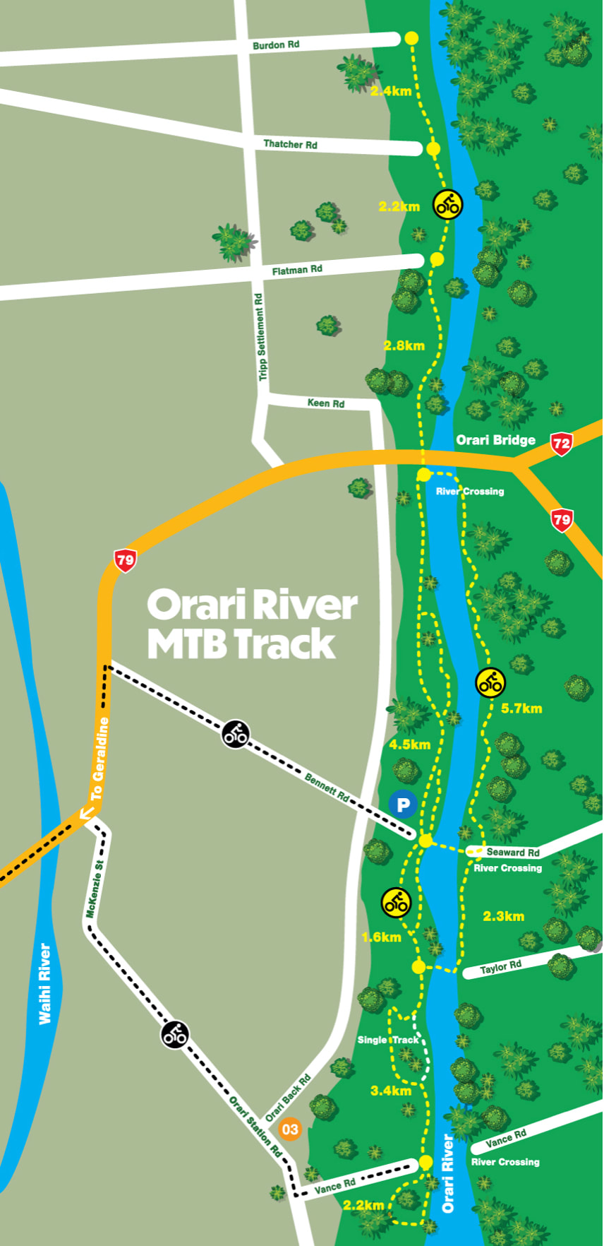
To start at the northern end, take the Main North Road north out of Geraldine (SH79), cross Orari Bridge and veer right (still on SH79). About 100 metres after the corner, take the very sharp right hand track that doubles back towards the bridge and park by the river. Alternatively, take Bennett Road east off SH79, about 1 km north of the outskirts of Geraldine and go to the very end (ca. 500 metres after crossroads with Orari Back Road). Access the track straight on from the end of the road.
Description
A gravel cycle and walking track that runs down both sides of the Orari River, and thus provides the opportunity for a long loop walk. On the west bank, too, there are plenty of deviations and loops, so that you can construct your own route. Like most riverside trails in New Zealand, somer of it is scrubby and often there are sections that have been damaged by recent floods - and others that the loons and hoons have despoiled. But for locals and visitors alike, it's a good workaday track for exercising both owner and dog. (Not to be confused with the Orari Gorge walk which is non-dog).
Connecting tracks
 
Further information
https://www.trailforks.com/region/orari-17640/
If you've found this website helpful, you might also want to look at some of my novels and poetry. These, like my dog-walking, are drawn from a love of nature and the countryside. To learn more, click here.