Name |
Hanmer Forest |
Location |
Hanmer Springs |
Co-ordinates |
1586863 5292634 |
Alternative co-ordinates |
1589806 5295978 |
Configuration |
Linear |
Distance |
|
Status |
Off-leash |
Grade |
Easy-Moderate |
Access |
Numerous access points from Hanmer Springs. Main entrance on Jollies Pass Road, ca 1 km east of township. |
Description |
A beautiful and varied network of winding walks through native and planted bush, open parkland and mountain scrub, including a lovely scupture trail. Options, also, to walk far up into the hills above Hanmer Springs. Be prepared to get lost - and enjoy the experience! |
Connecting tracks |
St James Conservation Park |
Further information |
Hanmer Forest Walks
Hanmer Springs is a popular and busy tourist spot that attracts visitors both for skiing and for its hot spa pools. But it's also an excellent walking and cycling location with tracks and paths to satisfy every taste. Add to this the fact that almost all the walks are dog-friendly, and that the town boasts several really great restaurants, and you have one of the best venues for a holiday in New Zealand.
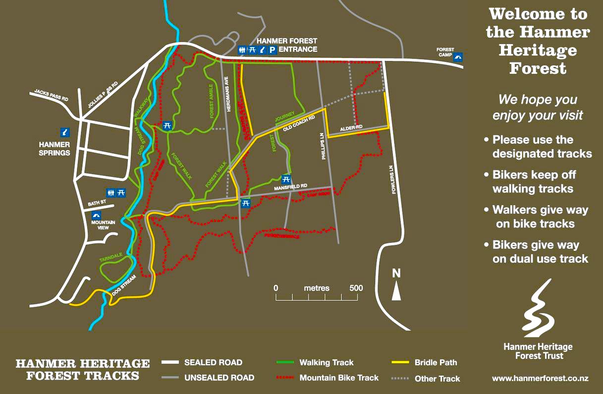
The walks spread out in a complex network through the forests to the east and north of Hanmer Springs, and extend far into the hills beyond. There are essentially two main sets of walks: a lower group of easy and generally flat walks through forest and parkland, easy to access and close to the village, and a more adventurous spider-web of tracks through the wooded valleys and onto the open slopes of Mount Isobel. In total they must amount to 50 km or more of walking, and because they are so interconnected they offer an almost endless menu of possibilities, from twenty minutes or so to a day or more in length.
The 'park walks' are all based on a pleasant area of woodland and grassy parkland which stretches up the east side of the village, along the line of the aptly named Dog Stream. It's terrace-land, so the paths are generally flat and easy with short steeper sections as you move from one level to another. The paths are gravel-bedded, but between them there's a winding series of connecting links and loops of more informal paths, carpeted with soft larch needles and the leaves of birch and oak. Most are well labelled and there are good maps at the key entry points to the paths, but it's still easy to lose yourself for a while. The rather unimaginatve names of some of the walks - Forest Walk, Forest Amble, Forest Journey, Woodland Walk - also add to the confusion. But hey, it's a lovely area, with abundant birdlife and a wide mix of trees; it's fun to be lost. On the south side of Jollies Pass Road, there's also a sculpture trail (essentially along Forest Amble) populated with huge wooden dogs and possums and mice and Golems. And north of Jollies Pass Road, the paths link with a wide grassy area where the dogs can run free and wild.
The 'hill walks' run north of this area. They include a short and well-graded zig-zag walk up Conical Hill to a lookout which provides a good panorama of the Hurunui Valley and hills beyond, and two loop walks, forming a figure of eight, that lead to Dog Stream Waterfall.The first of these loops (Woodland Walk) is an easy amble; the second (Timberlands-Waterfall paths) is rather more serious, with quite a bit of climbing, and some rough and potentially slippery sections that need a bit of care. And beyond these are longer walks up onto Mount Isobel. Most of these can all be accessed either from Woodland Walk or - to cut out the lower sections - by driving up Mullins Road to either the Larches or Waterfall Car park, and walking from there. Larches also gives access to a short (20 minute loop) nature walk, with occasional benches and equally occasional labelled trees. In addition, there are two long walks starting on the west side of Hanmer Springs, one (Chatterton River) at the end of Chatterton Road, and the other (Jacks Pass) on Clarence Valley Road.
I should add a word about the restaurants. This website isn't sponsored in any way, so I don't usually do endorsements, and ones I do offer are purely personal. As a tourist site, Hanmer has a range of cafes and restaurants, most of them the usual sort of suspects selling pub and takeaway-type foods, or run-of-the-mill menus. (When we were there, quite a few had also closed down, which is a sign of something or other.) But two of the restaurants stand out. Number 31, is place of real class, with excellent food, a good atmosphere and professional staff. And MK (in unit 3 in the little precinct) is simply amazing. Run by a charming and enthusiastic owner, it offers food like you'll probably never encounter elsewhere in New Zealand: 'dumplings' in various forms (raviolli, empasadas, and pierogies), all served with unique salads, (and all of which the owner carefully explains, to be followed by the most amazing hand-crafted desserts. So if you go to Hanmer, don't just go for a day or to walk. Make sure you stay long enough to savour the food!
Hover on the map to zoom in