Deerford Loop
Our son Matt, his partner Sim, along with Little Dog, have all gone home the previous night. Without Matt to challenge us with one of his hikes, we decide therefore that we’ll go for an easier walk than the two he’s led us on. But finding an easy walk in the Ruahines isn’t as easy as it seems. Our first attempt – to do the Pohangina River walk – failed, when we arrived to find that it not only involved a large amount of boulder hopping (not fair on the two dogs after such an energetic trip) but also repeated stream crossings. Our second attempt – to do the Deerford Track loop from the southern entrance point on Umutoi Road, fared no better. The DOC booklet is no doubt right when it states that there is 'legal access' from this point, but try telling that to the rancorous, paranoid and plain unfriendly farmer who claims to own the road thereabouts. (I’d encourage you to head that way, and demand your rights, if only to wind him up – but don’t expect to get his approval.)
Luckily plan C – Deerford Track from the northern entrance – brings belated success. We park in the small car park at the end of Limestone Road, and head off on what’s billed as a 3 hour loop walk.
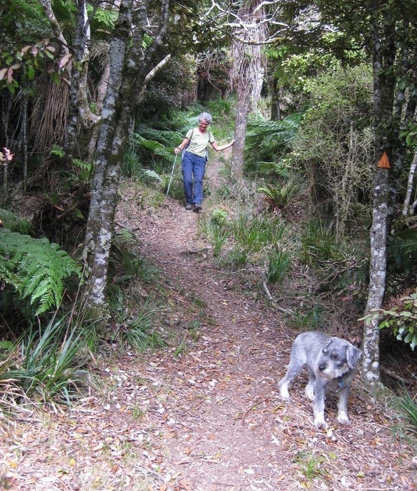
Once we’ve persuaded Mozzy to push through the fence, and Midge (for whom such things are filled with far too much danger) to allow us to lift him over the style, the walk starts with a five minute stroll, with dogs on leads, across a grassy paddock. At the next stile, both dogs co-operate a little more and jump over, after which it’s another five minutes down a bushy track to the river. The path on the other side isn’t obvious, and we make the mistake of taking a slightly angled route across the boulders, which leaves us with a scramble up the slope to join the track near to the forest park sign. But from there, it’s just a quick zig and a zag upslope, on a narrow and wet path, until we reach the bush proper, and step out onto the leafy-softness of the beech forest.
For the next ten minutes or so, this pleasant, more-or-less flat path, weaves its way through the beech forest, past numbered sign posts that – had we downloaded the information leaflet from the web – would have indicated what trees and bushes we were looking at, and perhaps something about the ecological history of the area. As it is, we stab a few guesses and wander on until we reach the junction and decision time: left and clockwise round the loop or right and anti-clockwise. The map in the car park indicated that the leftward route offers the gentler ascent (yes, there’s a hill to climb), but at the cost of course of a steeper decent later. We think about it briefly, then go left, and after a few minutes walk out into a small sunny glade – just right, after our delayed start, for a languid lunch.
After that, we get another five minutes or so of easy going, until the track suddenly turns right, and the ascent begins. It takes perhaps half an hour to do it, and in truth it’s never really hard. The path twists and turns at a steady gradient up the slope, without demanding that we scramble, yet steep enough to require an occasional pause to catch our breath. We’re walking at first through a mix of tall mountain beech, soft tree fern and what we think is a form of horopito – an attractive tallish bush with a mixture of reddish-purple and green leaves. As we ascend, however, the vegetation gradually changes: the beech become more stunted, the horopito (if that’s what it is) begins to dominate, the fern trees disappear.
As with all hills, the summit teases, promising to be at the top of the next rise, then scuttling away again. But after a last haul of thirty metres or so, we reach the highest point on the loop, where the Shorts Track to Toke Trig branches off. We pause there briefly, then head on down the Deerford Track, to complete the loop. And I mean down. Now we see how wise we were to take the clockwise route, for the path descends in long steep sections, more-or-less straight down the hillside. Going is slow, so it’s another thirty minutes before the track levels out, but on the way we get occasional views south-west towards Kimbolton, and nearer at hand the bush remains a delight. As the gradient lessens, rata become more abundant, with huge epiphytes on the boughs of the beech, and winding vines creeping up the trunks. Where they join, intertwine and then fuse into one, they make strange shapes: a monster’s face with a huge, bulbous nose; a group of long-necked animals, misshapen giraffes or dinosaurs of some sort, performing a riotous May dance. We pass an occasional young rimu, its hanging fronds pale against the darker canopy of the beech. Then we come out into a grassy glade, and wonder for a moment which way we should go, before instinct takes us along its topside, and shows us the track continuing through the bush. Five minutes later, we’re back at the junction with the entrance track, where we’d started the loop.
We make our way back to the stream, drawn on by the shouts and squeals of children playing in the pools somewhere near the crossing point. But as we turn down the slope, they suddenly stop, as if turned off, and when we reach the stream, crossing in the right place this time, there’s no-one in sight. But we pass them later, fifty or so schoolchildren with their teachers wending their way back to the camp on Limestone Road – tired and happy, and like us one hopes (for the sake of the teachers) ready for a good night's sleep.
Luckily plan C – Deerford Track from the northern entrance – brings belated success. We park in the small car park at the end of Limestone Road, and head off on what’s billed as a 3 hour loop walk.
Once we’ve persuaded Mozzy to push through the fence, and Midge (for whom such things are filled with far too much danger) to allow us to lift him over the style, the walk starts with a five minute stroll, with dogs on leads, across a grassy paddock. At the next stile, both dogs co-operate a little more and jump over, after which it’s another five minutes down a bushy track to the river. The path on the other side isn’t obvious, and we make the mistake of taking a slightly angled route across the boulders, which leaves us with a scramble up the slope to join the track near to the forest park sign. But from there, it’s just a quick zig and a zag upslope, on a narrow and wet path, until we reach the bush proper, and step out onto the leafy-softness of the beech forest.
For the next ten minutes or so, this pleasant, more-or-less flat path, weaves its way through the beech forest, past numbered sign posts that – had we downloaded the information leaflet from the web – would have indicated what trees and bushes we were looking at, and perhaps something about the ecological history of the area. As it is, we stab a few guesses and wander on until we reach the junction and decision time: left and clockwise round the loop or right and anti-clockwise. The map in the car park indicated that the leftward route offers the gentler ascent (yes, there’s a hill to climb), but at the cost of course of a steeper decent later. We think about it briefly, then go left, and after a few minutes walk out into a small sunny glade – just right, after our delayed start, for a languid lunch.
After that, we get another five minutes or so of easy going, until the track suddenly turns right, and the ascent begins. It takes perhaps half an hour to do it, and in truth it’s never really hard. The path twists and turns at a steady gradient up the slope, without demanding that we scramble, yet steep enough to require an occasional pause to catch our breath. We’re walking at first through a mix of tall mountain beech, soft tree fern and what we think is a form of horopito – an attractive tallish bush with a mixture of reddish-purple and green leaves. As we ascend, however, the vegetation gradually changes: the beech become more stunted, the horopito (if that’s what it is) begins to dominate, the fern trees disappear.
As with all hills, the summit teases, promising to be at the top of the next rise, then scuttling away again. But after a last haul of thirty metres or so, we reach the highest point on the loop, where the Shorts Track to Toke Trig branches off. We pause there briefly, then head on down the Deerford Track, to complete the loop. And I mean down. Now we see how wise we were to take the clockwise route, for the path descends in long steep sections, more-or-less straight down the hillside. Going is slow, so it’s another thirty minutes before the track levels out, but on the way we get occasional views south-west towards Kimbolton, and nearer at hand the bush remains a delight. As the gradient lessens, rata become more abundant, with huge epiphytes on the boughs of the beech, and winding vines creeping up the trunks. Where they join, intertwine and then fuse into one, they make strange shapes: a monster’s face with a huge, bulbous nose; a group of long-necked animals, misshapen giraffes or dinosaurs of some sort, performing a riotous May dance. We pass an occasional young rimu, its hanging fronds pale against the darker canopy of the beech. Then we come out into a grassy glade, and wonder for a moment which way we should go, before instinct takes us along its topside, and shows us the track continuing through the bush. Five minutes later, we’re back at the junction with the entrance track, where we’d started the loop.
We make our way back to the stream, drawn on by the shouts and squeals of children playing in the pools somewhere near the crossing point. But as we turn down the slope, they suddenly stop, as if turned off, and when we reach the stream, crossing in the right place this time, there’s no-one in sight. But we pass them later, fifty or so schoolchildren with their teachers wending their way back to the camp on Limestone Road – tired and happy, and like us one hopes (for the sake of the teachers) ready for a good night's sleep.
SummaryLocation: end of Limestone Road, off Table Flat Road
Access: Car parking area at end of road Length: ca. 3.5 km Configuration: Loop Grade: Steep, but with a gentle start and finish Status: off leash (under control); on-leash on farm track Cafes and restaurants: None locally More information: http://www.doc.govt.nz/parks-and-recreation/tracks-and-walks/manawatu-whanganui/manawatu/deerford-track-to-makiekie-creek/ |
|