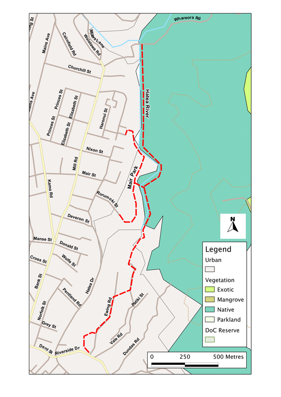
Hatea River
This walk starts at the small grassy domain just behind the Elliott Street aquatic centre, where a gravel track leads us to a boardwalk, which then winds through the mangroves flanking the Hatea River. When the tide is right, we might see the shadowy stripes and shapes of gurnard between the projecting roots. People in this part of New Zealand tend to have a low opinion of mangroves, and in several places there’s a strong call from boaters and fishermen to have them removed. In reality, however, the mangroves are there because of the volume of sediment being washed down the river – inflated in some cases, no doubt, by the clear-felling of large areas of forestry in the catchment of the river. And once there, the mangroves do a good job. They trap and bind the sediment, so that it doesn’t sweep out to the coast and change the balance of erosion and deposition on the beaches. They also create rich ecosystems that harbour young fish and other animals, and help to sustain the wildlife in the shallow estuarine waters.
At the end of the boardwalk, we do a dogleg left 300 metres down Ewing Road, then right along a small trackway and up a short flight of steps between houses, then left again for 50 m or so down Vale Road. Where this ends, there’s a sign to the scenic reserve, and the comforting symbol of a man walking a dog (it’s always good to know that we’re welcome). The walkway continues down a short slope before entering the bush, then rises and falls again, down to the river. We follow this, with glimpses across to the grassy terrace of Mair Park for another two hundred metres or so, past signs of the eel which mark the track, until we come to a pedestrian bridge over the river.
This is a good place for a quick breather, standing on the bridge and watching the river slide rather reluctantly toward the sea, and the ducks perching on the rocks, as though afraid to get their toes wet. The park is also well worth a diversion: there’s a loop track through a woody area which includes a scattered grove of kauri. And it’s the best spot on the walk for a picnic, as well as the last real chance for a while for the dog to have a paddle. But the main walkway veers to the right, away from the bridge, and heads briefly uphill, before curving left again to follow the stream. The bush is thick now: fern trees, nikau and white pine in profusion. A few of the more notable trees – a rimu here, a kauri there - have nameplates, though they were obviously put there some years ago for they seem to be sinking into the trunks, and aren’t always easy to read. And the river seems more vociferous, burbling away to our left as it picks its way between the boulders.
For the next 2 km or so, we continue like this, ignoring the temptation of the side-paths to our right (from which dogs are banned, though there are no signs to tell you). The path undulates: here over a low bluff, there along a short section of boardwalk at the head of gullies or the base of a cliff, then down at river level again, by a broad slow-moving pool where kids sometimes swim. Then, suddenly, the bush opens out and we enter a grassy glade, at the far end of which is Whareora Road.
Here, if you want, we can turn right and follow the footpath for a kilometre or so, until we come to A H Reed Memorial Kauri Park. From there, a couple of loop tracks lead through bush (in one place on a raised boardwalk, almost at canopy level), while the main path winds on up-valley for another 2 km to the majestic Whangarei Falls. However, all this is off limits for dogs – so you’ll need to come back another time to complete this section of the walk. Instead, it’s probably time to turn round and make our way back. As we go, it's worth looking out for some of those tiny treasures that we missed on the way out. The fern-shadows feathering the track, the face cut with a few quick strokes in the ponga trunk by the path, the knots of epiphytes and strands of lichen on the trees across the river.
SummaryLocation: North side of Town Basin, Whangarei (across Riverside Drive).
Access: Elliott Street carpark, off Riverside Drive; alternatively from Mair Park or Waioroa Road. Length: ca. 3.5 km (one way) Configuration: There-and-back (with side-tracks in Mair Park) Grade: Gently undulating; gravel surface; waymarker - an eel Status: on leash Cafes and restaurants: Several cafes on marina, ca. 400 metres south of Elliott Street More information: Whangarei walks. Available from Whangarei District Council: http://www.wdc.govt.nz/FacilitiesandRecreation/WalksTrails/Pages/ HateaRiver.aspx |
|