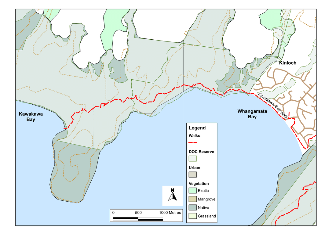
W2K Walk: Kawakawa Bay
Kinloch sits in a big bay between two headlands. From the town there are at least three dog walks you can do from Kinloch - and all of them are worthwhile. Two start on the south-east side of town and offer either a loop walk on the eastern headland or a longer there-and-back hike into Whaikapo Bay. The third sets off to the north-west and crosses the western headland into Kawakawa Bay. Together they all make up what's called the W2K walk.
The route west involves a strenuous climb, but brings rewards aplenty: long shady walks through rich woodland, great views of the lake, some spectacular rocks, dank wetlands, and a glorious and sheltered beach where you can swim of do almost anything else that takes the fancy.
It all starts gently enough with a stroll through town and out along the beach until we get to the true beginning of the walk, at the edge of the DoC reserve. After that, we climb gently for a kilometre or so until the path heads up, towards the ridge. For the next two kilometres it's steady climbing, relieved by the occasional downward section into one of the valleys that runs off the headland. The bush, though, is beautiful, with sun dappling through the trees and making crystal filigrees of the spider webs. After a while, we begin to wonder if the map might be wrong: surely we should have reached the top by now. The track teases us, with another twist, another turn, another last slope.
But eventually it stops its games, and the slope lessens. We cross the ridge line and get views of what's ahead. A little below us is a huge rock, poking from woodland - silver in the sun. Beyond, the flat blue expanse of the lake, with boats dotted around like jewels - and looking almost as expensive.
The walking now is easier, and the dogs are soon bounding ahead - knowing as they always do that down means water. We pause to climb onto the rock and admire the views; then its downward again in what feels like a wide arc, until first fern trees, and then toe-toe and reeds begin to appear to either side. Soon after that, we step out of the bush into an area of wetland, with boardwalks to carry us through. And then, we're at the beach, and the dogs rush into the lake and stand there up to there tummies, still not sure whether this is the real stuff or that horrible salt-water that they can't drink.
While we eat our lunch, we watch a family learning to ski out in the bay, and we wonder about the pumice on the shore and why it doesn't all float away on the lake... And later, with that conundrum still puzzling us, turn and head back.
SummaryLocation: Kinloch, 20km west of Taupo
Access: From the carpark beside the information centre at the marina in Kinloch Length: 15km return Configuration: There-and-back Grade: Undulating to steep; well-formed trail Status: off-leash (on-leash in some areas) Cafes and restaurants: Waterside Restaurant and Bar, Kinloch More information: http://www.doc.govt.nz/parks-and-recreation/tracks-and-walks/central-north-island/turangi-taupo/walks-further-out-of-taupo-township/ |
|