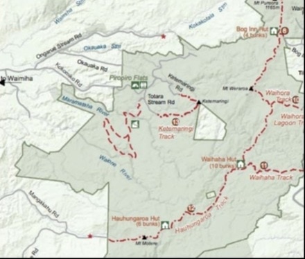
Ketemarangi Track
Pureora Forest is a large area of dog-friendly land, much loved by hunters, but open also to walkers and cyclists. Nestled in the middle of the forest is the open and expansive Piripiro Flats - a basic yet comfortable campsite, which makes a good starting point for one of the longer walks, as well as one of the cycle routes.
On a sunny summer morning, and full of optimism, we take the walk, planning on completing the full loop up to the peak of Ketemarangi, down the other side and back via forest roads - a distance of some 20 km or so. After two or three false starts, trying to find the right exit from the campsite, we manage to head off in the correct direction, right (and south) down Totara Stream Road. We follow this. ignoring the side-tracks, for about 2.5km. It's fairly easy going, and at this time of day it's not yet hot, though we're all puffing a bit on some of the hills for it's our first real walk in a long time. At the end of the road, we're therefore thankful to turn right, between the bollards, and make our way down to the stream where we rest and the dogs paddle and take a drink.
We cross the stream by a convenient log and follow the track uphill. It was clearly once a logging road, but the gravel surface is now deeply runnelled by water and the hungry tyres of quad-bikes and hunting vehicles, so in several places there are short diversions to avoid particularly deep and hazardous hollows and puddles, or to negotiate slippery humps. After about 1km, the track levels out and the surface softens as it becomes increasingly overgrown. Toi-toi crowds in on us from the verge, as if straining to watch where we go. After another 3.5 km, the track divides, and we pause for a while wondering which route to take - uphill or down. We take the latter, and soon find ourselves in an informal campsite, called Beerhaven - so it's easy enough to guess what goes on here. But then the path shoots up a slope and a hundred metres later joins the uphill route we'd so hesitantly declined.
The trail now is grassy, and undulates slowly upward, broken by occasional steeper sections. Tuis call from the branches of the taller kahikatea trees. We pass a quadbike parked in the trail by hunters, off after deer or pigs. We walk through a grassy glade, then into denser woodland. After another 500 metres the path flattens again, and we find ourselves wandering between Entish-looking trees, all bent and gnarled and thick with moss and lichen. It's dark and cool. The track-makers must have liked it here, for they seem to have stretched out the route as much as they could by winding it this way then that for no obvious reason. We wander on for another 2km or so, looking for something that might be called the summit, or a hint that we're on our way down. But it's well past mid-day now, and we're getting hungry, so without any really obvious feature to mark the place, we eventually stop beneath one of the more characterful trees and have our lunch.
Afterwards, there's a short debate: shall we go on, or turn back? We go for the coward's way and retrace our steps. It's quicker in this direction, and down almost all the way. But there's just time as we do the last stretch along the road for us to get dowsed by a heavy afternoon shower - which of course stops as soon as we get back to the camp. The day ends picking seeds out of the dogs' fur, while the cicadas chorus from the darkening circle of trees and the voices of the hunters drift across to us from the other side of the camp.
Note: For dog-walking, you need a permit from the regional DoC office - which is easily and freely obtained.
SummaryLocation: From Piripiro Flats, on Kokomiko Road Road; take Waimiha Road off SH30 3.7km west of Benneydale; after 4.6km becomes Poro-O-Tarao Road; further 8.5km left onto Ongarue Road Stream Road; after 4.5km right onto Kokomiko Road; campsite ca. 5km.
Access: Follow Totara Stream Road south from campsite either on foot, or drive and park in car park above stream crossing. Length: ca 20 km round trip (but we did a 15km there-and-back walk) Configuration: loop or there-and-back walks Grade: Undulating to steep; gravel forest roads and hiking trails Status: off-leash; permit required - may be obtained free of charge from helpful folk at Maniapoto Area Office: phone 07 878 1050; email [email protected] Cafes and restaurants: none locally More information: http://www.doc.govt.nz/Documents/parks-and-recreation/tracks-and-walks/waikato/pureora-forest-park-brochure.pdf |
|