And the dog came too... dog walks in New Zealand
  • Home
  • Introduction
  • Notes for Users
  • Alarums and Excursions!!
  • South Island
    • North-West >
      • Atua Stream Walk
      • Barnicoat
      • Ben Nevis
      • Botanical Hill
      • Boulder Bank
      • Brooklyn
      • Collingwood Beach
      • Collingwood Cemetery
      • Cotterell Road
      • Dellside
      • Dicker Road
      • Dominion Flats
      • Eves Valley Road
      • Faulkner Bush
      • Grampians
      • Great Taste Trail - Richmond
      • Great Taste Trail - Kohatu
      • Great Taste Trail - Wakefield
      • Hacket Valley
      • Hoddy Estuary Reserve
      • Hoddy Road
      • Kawatiri Rail Tunnel walk
      • Kina Beach
      • Maitai Valley
      • Mapua Headland
      • Marahau Beach
      • Marahau Forest
      • Mead Stream
      • Milnthorpe Forest
      • Motueka Inlet
      • Motueka Spit
      • Pakawau Beach
      • Paton's Rock
      • Paynes Ford Tramline Track
      • Pearse Valley
      • Pohara Beach
      • Rameka Creek
      • Red Hills
      • Ridgeview Road Walkway
      • Robson Reserve
      • Rough Island
      • Sharlands
      • Split Apple Rock
      • Stagecoach Road
      • St Arnaud Loop Walk
      • Tahunanui Beach
      • Tantragee
      • Tasman View Road
      • Teetotal
      • Two Rivers
      • Waimea Fish-Out Ponds
      • Waimea River Trail
      • Wairoa River Left Branch
      • Waiwhero Forest
      • Waiwhero Ridge
    • North-East >
      • Archer's Track
      • Blairich Reserve
      • Cullen Creek
      • Cullen Point
      • Davies Bay Track
      • Esson's Valley Tracks
      • Goulter River
      • Grovetown Lagoon
      • Half Moon Track
      • Kotuku Trail
      • Lake Chalice
      • Link Trail East
      • Link Trail West
      • Lower Wairau
      • Mount Baldy and Mount Royal
      • Mount Barrett Walkway
      • Mount Fell
      • Mount Fishtail
      • Mount Richmond
      • Mount Riley
      • Mount Robertson
      • Mount Stokes
      • Mount Takorika
      • Ngakuta Bay
      • Nydia Track
      • Opouri Bridle Track
      • Patutu Walk
      • Pelorus Track
      • Piwakawa Track
      • Rarangi
      • Sawcut Gorge
      • Snout Tracks
      • Taylor's Valley
      • Tirohanga
      • Wairau River
      • Wakamarina Track
    • West >
      • Alborns Track
      • Big Rimu Tree walk
      • Charming Creek
      • Chasm Creek
      • Coalbrookdale
      • Denniston Historic Walkway
      • Denniston Plateau
      • Gentle Annie Point walk
      • Goldsborough Tracks
      • Haast-Paringa Cattle Track
      • Kawatiri Beach Trail
      • Kawatiri River Trail
      • Kumara Community walks
      • Lake Hanlon
      • Larry's Creek
      • Mikonui River
      • Millerton Bathhouse Track
      • Moeraki Valley Track
      • Mokihinui Stopbank
      • Mount Adams
      • Mount Glasgow
      • Mount Haast Route
      • Murchison Tree Walks
      • Murray Creek
      • Old Ghost Road
      • Porika Road
      • Powerhouse and Lookout Walks
      • Progress Water Race
      • Ross Goldfield Walks
      • Skyline Walk
      • Stafford Bay Loop
      • Wanganui River
      • Whataroa Walks
      • Whitcombe Loop Tracks
      • Whitcombe Valley Track
      • Zig-Zag Track
    • Central-North >
      • Balmoral Lookout
      • Bottle Lake
      • Cheviot Hills Reserve
      • Childrens Bay Farm
      • Craigieburn Forest
      • Culverden Domain
      • Diamond Harbour
      • Ellangowan Scenic Reserve
      • Garden of Tane
      • Godley Head
      • Governors Bay
      • Halswell Quarry
      • Hanmer Forest Walks
      • H W Hart Arboretum
      • Ka Whata Tu o Rakihouia
      • Kaikoura Trail
      • Kowai Bush Reserve
      • Kowai River
      • Lyttleton Coastal Walk
      • Lytteleton Hills
      • McCleans Forest
      • McHughs Forest Park
      • Mears Bush
      • Mount Grey
      • Mount Oxford
      • Mount Richardson
      • Mount Thomas
      • Newton Falls
      • Ngaio Point
      • Panama Rock
      • Pegasus Bay
      • Rakahuri River
      • Sign of the Bellbird
      • Sign of the Kiwi
      • St James Conservation Park
      • Tutakakahikura Scenic Reserve​
      • Victoria Park
      • West Melton Forest
      • Woodills North
      • Woodills South
    • Central-South >
      • Ahuriri East Branch
      • Ahuriri Valley Tracks
      • Ashburton River
      • Benmore Peninsula
      • Centennial Park
      • Cowan's Hill
      • Dingle Burn
      • Double Hill
      • Freehold Creek
      • Greta and Dorcy Tracks
      • Gunns Bush
      • Hook Bush
      • Huxley and Hopkins Valleys
      • Kelceys Bush
      • Knottingly Park
      • Lake Emma walk
      • Lake Emily Tracks
      • Lake Hood
      • Lake Ohau Track
      • Lake Opuha Walk
      • Lake Tekapo Lakeside Walk
      • Lake Tekapo Regional Park
      • Lake Wainono
      • Lower Opihi River Track
      • Macaulay River walk
      • Methven walkway
      • Mount Barrosa
      • Mount Sunday & Mount Potts
      • Opihi River Walkway
      • Orari River Mountain Bike Tracks
      • Pareora River
      • Pioneer Park
      • Potts River Walks
      • Quailburn Track
      • Saltwater Creek
      • Snowy Gorge
      • Talbot Forest
      • Temple Valley Tracks
      • Waihao River
      • Waihi River Walk
      • Waimate Creek walks
      • Waitohi Bush
    • South-East >
      • Alexandra Anniversary Walk
      • Arawata Bridle Track
      • Arrow Gorge Loop
      • Arrowtown Millennium Track
      • Bannockburn Sluicings
      • Bob's Cove and Twelve Mile Delta
      • Boundary Creek
      • Bull Creek
      • Bullendale Track
      • Butcher's Dam
      • Central Otago Rail Trail
      • Chrystals Beach
      • Clutha Riverside Track
      • Commissioner's Track
      • Conroy's Dam
      • Cromwell-Pisa Walkway
      • Crystal Battery
      • Deans Bank Track
      • Diamond Creek Track
      • Dunedin Walks
      • Earnscleugh Tailings
      • Flagstaff Hill
      • Frankton Arm Walkway
      • Gabriel's Gully
      • Gibbston River Trail
      • Gladstone Track
      • Glendhu Bay Track
      • Glenorchy Boardwalk
      • Grovers Hill
      • Hawea River Track
      • Huriawa Pa Walk
      • Kanuka Loop
      • Lake Alta Track
      • Lake Hayes Trail
      • Lakeside Walk
      • Leith Saddle
      • Long Beach
      • Mapoutahi
      • Mosgiel Floodbank
      • Mount Cargill
      • Mount Crichton Loop
      • Mount Iron Track
      • Munro's Gully
      • Naseby Forest
      • Nevis Valley Tracks
      • Newcastle Track
      • One MIle Creek
      • Oteake Conservation Park
      • Outram Glen
      • Quartz Reef
      • St Bathans
      • Trotters Gorge
    • South-West >
      • Blair Athol Walkway
      • Boyd Creek
      • Manapouri cycleway
      • McLean Falls
      • The Bluff
  • North Island
    • Auckland & Waiheke
    • Coromandel & North Waikato
    • Wellington
    • The North
    • Manawatu & Wairarapa
    • The East
    • Taranaki & Central
  • Useful Links
  • Progress Water Race
  • Rock and Pillar Conservation Park
  • New Page
  • New Page
  • New Page
  • New Page
  • New Page
  • New Page

Kuakarau Bay and Hitapa Bay

An up-and-down walk along a rocky coastline, with views across to Auckland, then a return trip via country roads and bush tracks

Back to Regional Map

Summary

Location: Mary Wilson Reserve, Kuakara Bay

Access: Car parking beside reserve 

Length: ca. 5 km

Configuration: Loop 

Grade: Undulating with some steep sections; mix of informal paths, gravel tracks and country roads.

Status: on leash (with some off-leash sections)

Cafes and restaurants: none nearby

More information: http://www.aucklandcouncil.govt.nz/EN/parksfacilities/walkingtracks/Pages/waihekewalkseries.aspx
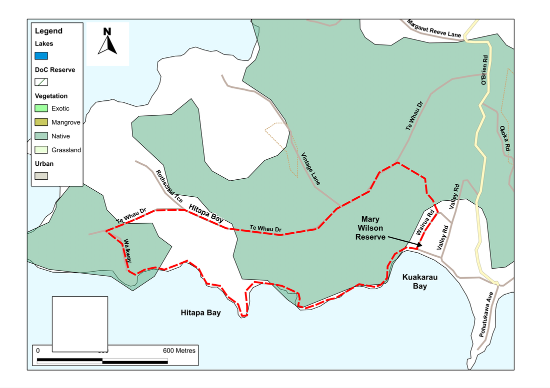
Picture

Description

Mary Wilson Reserve stands in a small inlet on the south side of the Te Whau peninsula, to the west of Rocky Bay (aka Whakanewha Bay).  The beach here is shingly, and nothing special.  But heading west, along the cliffs, is an interesting and varied walk.

It begins in front of the big house that nestles in the western corner of Kuakarau Bay.  As we pass, it's worth looking out for the large pieces of artwork in the garden and on the patio.  Steps lead us up to a narrow and zig-zaggy path through bush.  As we climb, the path becomes narrow in places (sometimes no more than half a metre wide), and there's a steep and uninviting fall to the rocky shore below.  Occasionally, though, we come out into an open glade, where the wind makes the grass lie flat, but from which we get views across to Auckland.  And after a while we drop down onto a small gravelly beach, backed by a grassy terrace.

Three times this happens: up onto the headland, down to a beach.  But then the route changes.  The coastal path stops and the track turns abruptly right and shoots uphill. It's a long, steep climb as we follow the straight fenceline.  Eventually, though, the track begins to level out, and just as our calves are beginninbg to recover we step out onto an open road.

Looking left, we can see  the entrance to a  winery and restaurant a hundred metres or so away.  Our route, however, goes right along Te Whau Drive.  This is not the best part of the walk, by any means: there's no pavement and the views that we initially get to south and north soon disappear as the bush closes in.  But eventually, after a long two kilometres, and passing the junction with Vintage Land, we come to a grassy paddock on the right of the road, and at the far end of this there's a welcome green sign saying Kuakarau Forest - Route to Rocky Bay.  

We take this gladly, and having crossed the paddock duck back down into the bush, following a path that's overhung by huge epiphytes.  After about 500 metres this brings us out onto Wainau Road, where we go right, downhill and within a couple of hundred metres more, find ourselves back at the beach where we started.

As described here, this walk is about 5 km.  Like other walks on Waiheke Island, it can easily be extended because it inevitably links with other dog-fdriuendly tracks.  One option is to head off down Vintage Lane and do an extra clockwise loop via this and Margaret Reeve Lane, ultimately joining path down the eastern edge of Kuakarau Forest, back to Mary Wilson Reserve.  This adds another  3.5-4 km to the length of the walk.   

If you've found this website helpful, you might also want to look at some of my novels and poetry. These, like my dog-walking, are drawn from a love of nature and the countryside. To learn more, click here.