And the dog came too... dog walks in New Zealand
  • Home
  • Introduction
  • Notes for Users
  • Alarums and Excursions!!
  • South Island
    • North-West >
      • Atua Stream Walk
      • Barnicoat
      • Ben Nevis
      • Botanical Hill
      • Boulder Bank
      • Brooklyn
      • Collingwood Beach
      • Collingwood Cemetery
      • Cotterell Road
      • Dellside
      • Dicker Road
      • Dominion Flats
      • Eves Valley Road
      • Faulkner Bush
      • Grampians
      • Great Taste Trail - Richmond
      • Great Taste Trail - Kohatu
      • Great Taste Trail - Wakefield
      • Hacket Valley
      • Hoddy Estuary Reserve
      • Hoddy Road
      • Kawatiri Rail Tunnel walk
      • Kina Beach
      • Maitai Valley
      • Mapua Headland
      • Marahau Beach
      • Marahau Forest
      • Mead Stream
      • Milnthorpe Forest
      • Motueka Inlet
      • Motueka Spit
      • Pakawau Beach
      • Paton's Rock
      • Paynes Ford Tramline Track
      • Pearse Valley
      • Pohara Beach
      • Rameka Creek
      • Red Hills
      • Ridgeview Road Walkway
      • Robson Reserve
      • Rough Island
      • Sharlands
      • Split Apple Rock
      • Stagecoach Road
      • St Arnaud Loop Walk
      • Tahunanui Beach
      • Tantragee
      • Tasman View Road
      • Teetotal
      • Two Rivers
      • Waimea Fish-Out Ponds
      • Waimea River Trail
      • Wairoa River Left Branch
      • Waiwhero Forest
      • Waiwhero Ridge
    • North-East >
      • Archer's Track
      • Blairich Reserve
      • Cullen Creek
      • Cullen Point
      • Davies Bay Track
      • Esson's Valley Tracks
      • Goulter River
      • Grovetown Lagoon
      • Half Moon Track
      • Kotuku Trail
      • Lake Chalice
      • Link Trail East
      • Link Trail West
      • Lower Wairau
      • Mount Baldy and Mount Royal
      • Mount Barrett Walkway
      • Mount Fell
      • Mount Fishtail
      • Mount Richmond
      • Mount Riley
      • Mount Robertson
      • Mount Stokes
      • Mount Takorika
      • Ngakuta Bay
      • Nydia Track
      • Opouri Bridle Track
      • Patutu Walk
      • Pelorus Track
      • Piwakawa Track
      • Rarangi
      • Sawcut Gorge
      • Snout Tracks
      • Taylor's Valley
      • Tirohanga
      • Wairau River
      • Wakamarina Track
    • West >
      • Alborns Track
      • Big Rimu Tree walk
      • Charming Creek
      • Chasm Creek
      • Coalbrookdale
      • Denniston Historic Walkway
      • Denniston Plateau
      • Gentle Annie Point walk
      • Goldsborough Tracks
      • Haast-Paringa Cattle Track
      • Kawatiri Beach Trail
      • Kawatiri River Trail
      • Kumara Community walks
      • Lake Hanlon
      • Larry's Creek
      • Mikonui River
      • Millerton Bathhouse Track
      • Moeraki Valley Track
      • Mokihinui Stopbank
      • Mount Adams
      • Mount Glasgow
      • Mount Haast Route
      • Murchison Tree Walks
      • Murray Creek
      • Old Ghost Road
      • Porika Road
      • Powerhouse and Lookout Walks
      • Progress Water Race
      • Ross Goldfield Walks
      • Skyline Walk
      • Stafford Bay Loop
      • Wanganui River
      • Whataroa Walks
      • Whitcombe Loop Tracks
      • Whitcombe Valley Track
      • Zig-Zag Track
    • Central-North >
      • Balmoral Lookout
      • Bottle Lake
      • Cheviot Hills Reserve
      • Childrens Bay Farm
      • Craigieburn Forest
      • Culverden Domain
      • Diamond Harbour
      • Ellangowan Scenic Reserve
      • Garden of Tane
      • Godley Head
      • Governors Bay
      • Halswell Quarry
      • Hanmer Forest Walks
      • H W Hart Arboretum
      • Ka Whata Tu o Rakihouia
      • Kaikoura Trail
      • Kowai Bush Reserve
      • Kowai River
      • Lyttleton Coastal Walk
      • Lytteleton Hills
      • McCleans Forest
      • McHughs Forest Park
      • Mears Bush
      • Mount Grey
      • Mount Oxford
      • Mount Richardson
      • Mount Thomas
      • Newton Falls
      • Ngaio Point
      • Panama Rock
      • Pegasus Bay
      • Rakahuri River
      • Sign of the Bellbird
      • Sign of the Kiwi
      • St James Conservation Park
      • Tutakakahikura Scenic Reserve​
      • Victoria Park
      • West Melton Forest
      • Woodills North
      • Woodills South
    • Central-South >
      • Ahuriri East Branch
      • Ahuriri Valley Tracks
      • Ashburton River
      • Benmore Peninsula
      • Centennial Park
      • Cowan's Hill
      • Dingle Burn
      • Double Hill
      • Freehold Creek
      • Greta and Dorcy Tracks
      • Gunns Bush
      • Hook Bush
      • Huxley and Hopkins Valleys
      • Kelceys Bush
      • Knottingly Park
      • Lake Emma walk
      • Lake Emily Tracks
      • Lake Hood
      • Lake Ohau Track
      • Lake Opuha Walk
      • Lake Tekapo Lakeside Walk
      • Lake Tekapo Regional Park
      • Lake Wainono
      • Lower Opihi River Track
      • Macaulay River walk
      • Methven walkway
      • Mount Barrosa
      • Mount Sunday & Mount Potts
      • Opihi River Walkway
      • Orari River Mountain Bike Tracks
      • Pareora River
      • Pioneer Park
      • Potts River Walks
      • Quailburn Track
      • Saltwater Creek
      • Snowy Gorge
      • Talbot Forest
      • Temple Valley Tracks
      • Waihao River
      • Waihi River Walk
      • Waimate Creek walks
      • Waitohi Bush
    • South-East >
      • Alexandra Anniversary Walk
      • Arawata Bridle Track
      • Arrow Gorge Loop
      • Arrowtown Millennium Track
      • Bannockburn Sluicings
      • Bob's Cove and Twelve Mile Delta
      • Boundary Creek
      • Bull Creek
      • Bullendale Track
      • Butcher's Dam
      • Central Otago Rail Trail
      • Chrystals Beach
      • Clutha Riverside Track
      • Commissioner's Track
      • Conroy's Dam
      • Cromwell-Pisa Walkway
      • Crystal Battery
      • Deans Bank Track
      • Diamond Creek Track
      • Dunedin Walks
      • Earnscleugh Tailings
      • Flagstaff Hill
      • Frankton Arm Walkway
      • Gabriel's Gully
      • Gibbston River Trail
      • Gladstone Track
      • Glendhu Bay Track
      • Glenorchy Boardwalk
      • Grovers Hill
      • Hawea River Track
      • Huriawa Pa Walk
      • Kanuka Loop
      • Lake Alta Track
      • Lake Hayes Trail
      • Lakeside Walk
      • Leith Saddle
      • Long Beach
      • Mapoutahi
      • Mosgiel Floodbank
      • Mount Cargill
      • Mount Crichton Loop
      • Mount Iron Track
      • Munro's Gully
      • Naseby Forest
      • Nevis Valley Tracks
      • Newcastle Track
      • One MIle Creek
      • Oteake Conservation Park
      • Outram Glen
      • Quartz Reef
      • St Bathans
      • Trotters Gorge
    • South-West >
      • Blair Athol Walkway
      • Boyd Creek
      • Manapouri cycleway
      • McLean Falls
      • The Bluff
  • North Island
    • Auckland & Waiheke
    • Coromandel & North Waikato
    • Wellington
    • The North
    • Manawatu & Wairarapa
    • The East
    • Taranaki & Central
  • Useful Links
  • Progress Water Race
  • Rock and Pillar Conservation Park
  • New Page
  • New Page
  • New Page
  • New Page
  • New Page
  • New Page

Little Oneroa - Enclosure Bay

A strenuous and varied walk that takes in two beaches,  some rugged cliffs, a Forest and Bird reserve and dense bush, as well as some easy roadside paths.  

Back to Regional Map

Summary

Location: Little Oneroa Beach, off Ocean Bay Road 

Access: Car park at Little Oneroa Beach

Length: ca. 5 km

Configuration: Loop with some repeated sections 

Grade: Undulating with some steep sections (often with steps); mix of informal paths, gravel tracks and roadside pavements.

Status: on leash (with some off-leash sections)

Cafes and restaurants: several cafes in Little Oneroa (ca 1 km from start/end point)

More information: http://www.aucklandcouncil.govt.nz/EN/parksfacilities/walkingtracks/Pages/waihekewalkseries.aspx
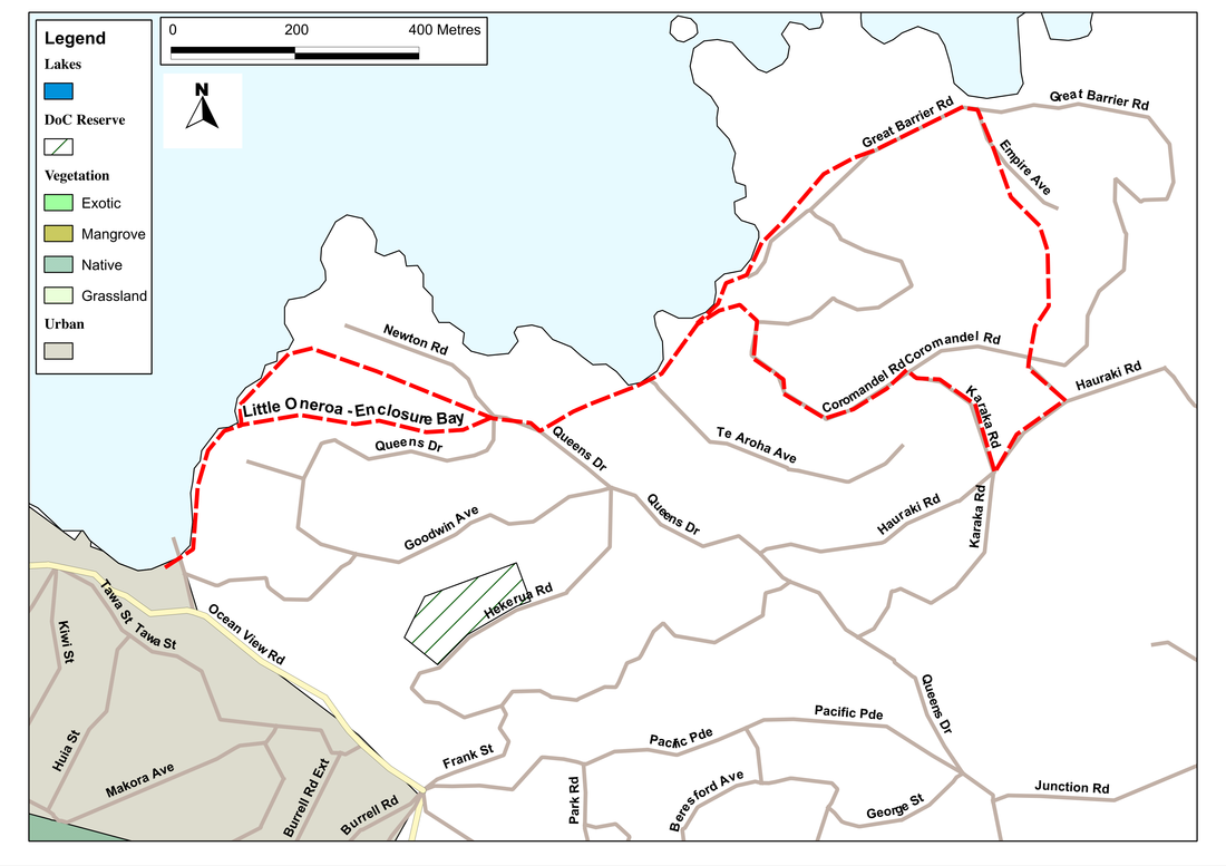
Picture

Description

Waiheke Island has a refreshingly relaxed attitude to dogs, and there's an abundance of walks to do.  Well, that's half true.  The west side of the island is good; the east contains a huge area belonging to an overly rich (and obviously paranoid) viniculturalist, where almost every field contains a huge sign saying 'Private, no entry, no camping, no fires, no dogs, no foreigners...' (OK, I lied about the foreigners, but the general message is clear.)   And if you're on Waiheke Island there are few better places to base yourself than Little Oneroa, for from here there's three or four really good walks.  (The nearby Punga Lodge hotel is also dog-friendly and offers excellent accommodation.)

The walk starts as a flight of newish-looking steps, heading east from Little Oneroa Beach.  Ignoring any diversions off to the right we climb these to the top of the headland, then down the other side to a little rocky bay with a picnic table.  The left fork here takes us uphill again, via more steps and a windy track to a small car park at the end of Newton Road.  Straight ahead, there's a short path to another picnic area at Fisherman's Point, but our route goes right, along Newton Road to a T-junction.  Left here, and after 200 metres we find ourselves beside a small grassy reserve, with a sign labelled Don's Track.

This will be our route for the next kilometre or so. The first section is steep, as we wind our way down the slope towards a small beach.  Just before we reach this, however, Don's Track leaps off to the right, and climbs again, as a pleasant 'green lane' until it gets to Coromandel Road.  Here we go right for a short distance, until we meet Hauraki Road, then left for about 100 metres, where we take another left.  Just before the junction with Great Barrier Road there's a sign inviting us into a Forest and Bird Reserve.  Enter this and we find we are faced with a myriad of paths through a large area of regenerating bush.

Which we take doesn't matter much, as long as the general direction is downhill.  At the bottom, we join a gravel road, where we go left (downhill again) and soon join Empire Avenue.  Follow this, and after a couple of hundred metres we come to a small beach, which nestles in the suitably names Enclosure Bay.  This is a good place for a rest because - as we might have guessed - the route now goes uphill again, with the sea on our right.  At first, we follow the road (marked as Great Barrier Road on the maps but signposted Empire Avenue), but in a few hundred metres a track leads off on the right, along the cliff edge.  We now take this, and wind our way up and down, around the headland, until we drop down onto another beach.  

Given all the ups and downs and lefts and rights we've done, we can be forgiven for feeling rather lost by now.  But it's soon apparent that we've just completed a rather wiggly circle and arrived back at Don's Track.  Now, therefore, we have to retrace our steps (yes, that means up that steep concrete path) until we get back to the T-junction at the end of Newton Road.  Here, there's a walkway leading more-or-less straight ahead.  We follow this as it winds downhill, often slippery, often rough, through an area of bush for about 700 metres until we find ourselves at the rocky bay with its picnic table that we saw on the route out.  To complete the walk, therefore, it's just a case of trotting up and over that first headland, back to Little Oneroa Beach.


If you've found this website helpful, you might also want to look at some of my novels and poetry. These, like my dog-walking, are drawn from a love of nature and the countryside. To learn more, click here.