Mangawhai Heads
From the carpark at the end of Wintle Street, in Mangawhai Heads, there's a choice of at least four walks, all of which are dog-friendly. One involves no more than a couple of hundred metres slog up a hill to a lookout point: worth it for the view of the huge fossil sand dune that all but blocks the mouth of the lagoon on which Mangawhai is built. A second involves a gentle stroll along the beach beside the lagoon.
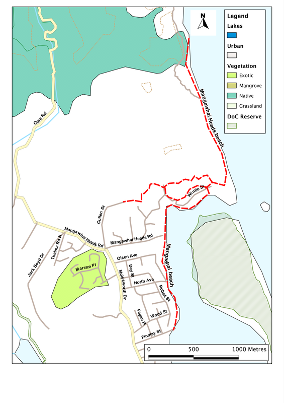
It's the other two options, however, that offer most scope and give most reward. The obvious choice is to take to the beach and head northwards. That's the way to the Mangawhai Cliffs walk - a 5 km trail along the cliff-tops towards Bream Tail. But that's on DoC and farm land so, sadly, is out of bounds for dogs. Even ignoring that, it's a pleasant walk along the beach for anything up to 3 km (depending on the tide), and there's plenty to see. As well as views across to the Hen and Chicken Islands and Little Barrier Island, we get close-ups of intricately eroded chunks of sandstone and limestone, lying where they've fallen on the beach, and of a sweeping face to one of the sand dunes, down which kids (and parents) love to roll and slide. There are also rock-pools to explore, and, after a couple of kilometre or so, a shingle beach which is a real cornucopia for any collector of curly sea shells.
The fourth option is the hard one, and offers a series of loop routes. This is the Goldschmidt track, named after the co-ordinator of the Mangawhai walking weekend (a great, annual event that always includes at least one special walk for dogs). I've never met Jean Goldschmidt, as far as I know - but I picture her with four cloven feet and two horns, for she certainly seems to have a goat-like predilection for clambering up steep hills!
The track starts on the north side of the main carpark, and heads up. And up. The first section offers the shortest loop, of about 1 km in length through bush and scrub, and taking in the summit of the first hill. If we're brave, however, we'll exit this loop at its westernmost limit, and head down to the road that forms a driveway into one of the gated housing estates that seem to be proliferating in this part of the coast. Cross this, and we head up a steep series of steps to the top of another ridge, where there's a welcome bench, and then down again into the next valley. Here we have the choice of escaping, via a small side street, back onto Wintle Street and thence left to the carpark. But if we're fit or foolhardy enough we can climb again through bush until we get to Cullen St. Left down this, and left again onto another section of track, and eventually we rejoin Cullen Street. Take a left and a right, cross the road at the bottom (Wintle Street), and soon we are on the beach, beside the lagoon. From there it's a gentle 10 minutes back to the carpark.
SummaryLocation: Wintle Street, Mangawhai Heads: from round-about at junction of Molesworth Road and Mangawhai Heads Road, head east along Mangawhai Heads Road; becomes Wintle Streey; continue to end.
Access: Carpark at end of Wintle Street Length: up to 4 km Configuration: Network of tracks offering there--and-back walks and loops Grade: Variable, from gentle and flat beaches to steep informal tracks over hills. Status: off-leash (under control) for the most part (on-leash on streets); summer restrictions apply on beaches. Cafes and restaurants: Sail Rock cafe in Mangawhai Village (1 km) More information: |
|