Little Oneroa to Matiatia Bay
If I were to do one dog walk on Waiheke Island, this would probably be it. It's got everything: beaches, forest, grassy pastures, steep cliffs and views at almost every turn.
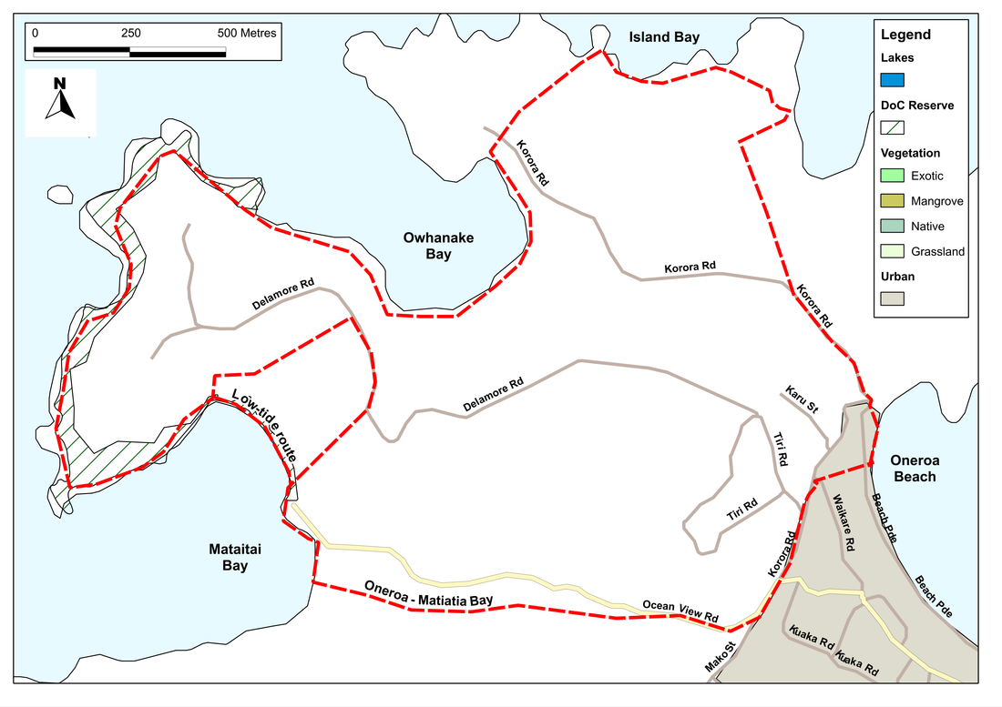
We start by making our way towards the northern end of Oneroa beach. Before the beach runs out, we take the boat ramp up onto the short continuation of Beach Parade, and then go left off this along Korora Road for about 300 metres. Here, just past the entrance to Fossil Bay Farm, there's a track running off to the right. We walk along this, right past a large field of vines, then left and a quick right again until we come through a hedge onto a rocky headland with a lookout. To our right is the deep inlet of Fossil Bay; to our left the broader Island Bay.
We take the track along the edge of the latter, then zig-zag down the slope onto a stony beach. Hardly have our feet touched the pebbles, however, and it's up again, along a soft grassy defile, with tall yukas and a boggy stream to our right. The path curves, crosses a track, then skirts a lovely sheltered bay. This is Owhanake Bay, and its our companion for the next kilometre or so. In the 1800s, the bay was a major source of shingle - and it's said that it went to make up a half of the city of Auckland. We cross a storm ridge that forms a barrier at the end of a peaty inlet, then climb our way steadily up a slope and follow the curve of the bay round to the right.
This is a lovely section of the path as we wind our way along the cliffs, through grassy brush and light bush. Once, then twice, we drop down to the beach, before climbing again up through large pasture fields, with an impressive residence above us on the flat plateau. After a short descent and a rise into and out of a small valley, we're back to the cliffs again, and follow these for another kilometre of glorious walking until we get to the southernmost tip of the peninsula. This is Mokemoke - the site of a fortified pa - and with a good eye we can see the imprint of house platforms and kumara pits.
Ahead of us now is Matiatia Bay, and it's quite likely that as this comes into sight we'll see one of the Aukland ferries steaming into or out of the bay. The path turns and winds along the edge of the bay, gradually descending to a narrow beach. If the tide is right, we can follow this all the way to the ferry terminal; at high tide, however, we may need to take a longish diversion at the northernmost corner of the bay to avoid getting our feet wet. This takes us up a concrete drive to Delaware Road, where we turn right. A few hundred metres later we come to a green sign on our right, offering us a tramping track to Matiatia Wharf. This leads us down through pleasand bushlands, onto a track beside a stream that comes out onto Ocean View Road. From there its a few steps to the wharf.
The ferry terminal seems a busy and crowded place after the solitude and wide vistas of the cliff walk. But if we continue along to the far end of the beach we soon escape the bustle and go up a short rise into the bush of Atawai Whenua Reserve. Here we're offered a plethora of routes - lower, upper and ones in between - and can choose according to how energetic still feel. The only requirement is to ensure that we head east. This takes us through the reserve, across a track, and then through another area of regenerating bush. If we choose our path right, we come out of this near the furthest corner, onto Ocean View Road. From here on its an easy roadside stroll for about a kilometre back to Oneroa.
SummaryLocation: Oneroa Beach
Access: Car parking on Beach Parade Length: ca. 8 km Configuration: Loop. Grade: Undulating; varied, with informal and well-formed paths, gravel tracks and roadside pavements. Status: on-leash (off-leash on beaches) Cafes and restaurants: Oneroa and ferry terminal at Matiatia More information: http://www.aucklandcouncil.govt.nz/EN/parksfacilities/walkingtracks/Pages/waihekeindividualwalks.aspx |
|