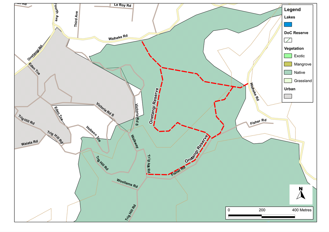
Onetangi Reserve
Forest and Bird own and maintain a growing number of reserves in New Zealand, most of which are open to the public, and a large proportion of these are dog-friendly. They are all worth visiting.
The reserve at Onetangi is no exception. The loop track provides a beautiful shady walk through native bush that includes a huge variety of trees including taraire, pohutakawa, kohekohe, kauri and puriri, as long as the usual suspects such as nikau, ponga, mamaku and kanuka. The trees seem to spill over with bird life, and at most times of the year we're fairly certain to see and hear plenty of native wood pigeon, kingfishers, fantails and tuis. There are also long-tailed eels, freshwater shrimps and crayfish in the streams.
There are four or five access points to the reserve, but the most convenient is probably that on Waiheke Road, about 1 km south of the sharp corner where it joins with Belle Terrace and Piemelon Bay Road. Here there's a wide enough verge to provide some parking.
From the gate, it's a short walk to the picnic table, where there are good views to the coast, and a short track to a lookout offering even better ones. The main track, however, heads off left into the bush, then soon afterwards splits: left (labelled Fisher Road) takes us around the loop clockwise, tight (labelled Waiheke Road) takes us anti-clockwise.
Heading left we soon get a taste of the diversity of the bush in the reserve, with a lovely mix of trees including nikau, rata and kahikatea. The track is relatively new, and winds up for about 500 metres until it meets Fisher Street. Here a path forks left to Trig Hill; we go right, parallel with Fisher Road, and keep a sharp lookout for another right turn after about 100 metres. (If we miss this, it's not a disaster, for a little further along is a grove of kauri trees, so we can see these before retracing our steps.)
The righthand path takes us back into the heart of the woodland, downhill through a glade of kohekohe (if my botany is right), where wood pigeons forage voraciously in the canopy. A little further on we pass the left-hand fork to Scotts Terrace, and a few hundred metres after that another track leading to Scotts Terrace. Again, we head right in the direction somewhat confusingly labelled Trig Hill. Now the path starts to climb beside a small stream (a welcome watering place the dogs), zigging and zagging its way up and up until we reach the point where we joined the loop.
SummaryLocation: Waiheke Island, ca. 1.5 km south-east of Onetangi.
Access: Entrances from Scotts Terrace (Hall's Gate in the west), Waiheke Road (Roy Nelson's Gate in the northwest and La Franchie Gate in the east) and Fisher Road (east and south). The best parking is probably from La Franchie Gate on the east, where there's room for parking on the verge. Length: ca. 3 km Configuration: Loop (with various options to join other tracks) Grade: Undulating with a few steep sections; informal path. Status: on leash Cafes and restaurants: Beachfront Cafe, Onetangi (ca. 2 km) More information: http://www.forestandbird.org.nz/what-we-do/reserves/onetangi-reserve |
|