Pouto Point
Pouto Point is an atmospheric place, in every sense of the word. It's exposed to both the wind and the sea. On one side, the water churns as tides rush through the narrow inlet to Kaipara Harbour. On the other, there seems to be a restless desert, shifting in the wind.
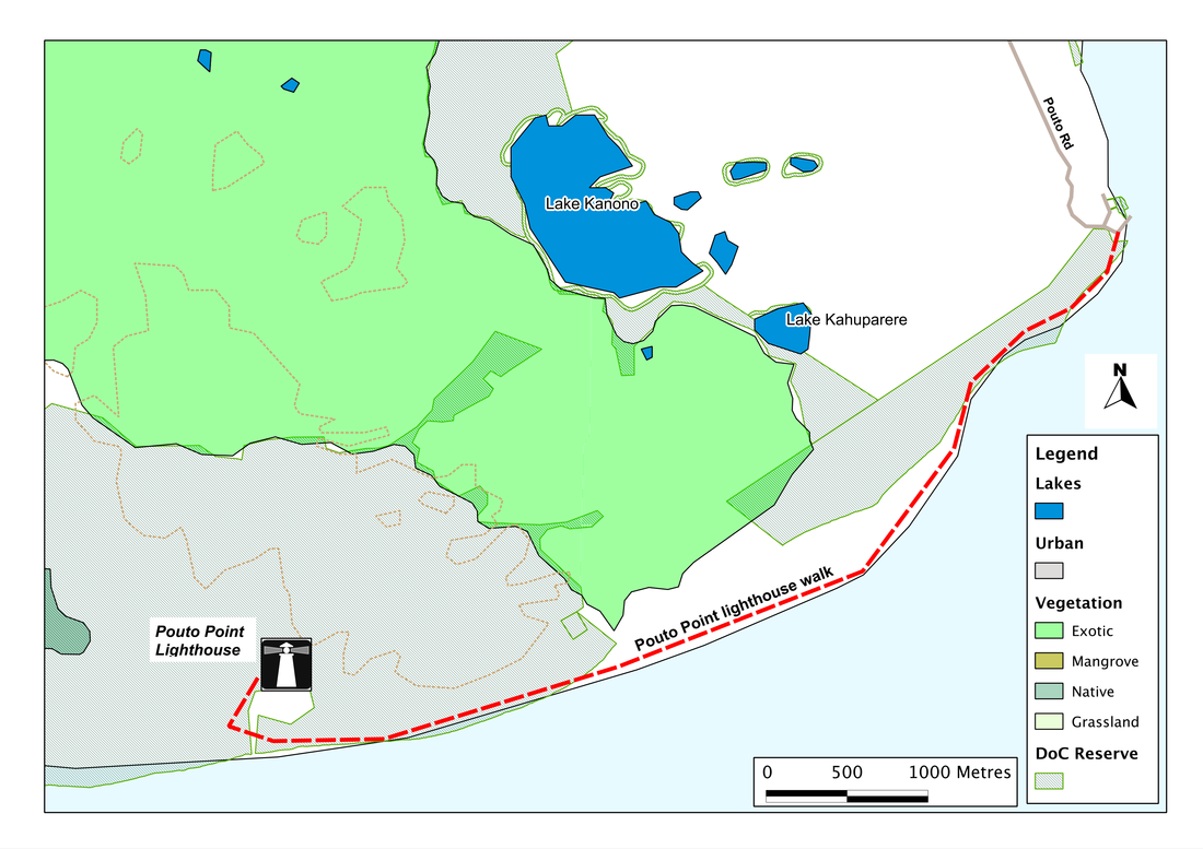
The start of the walk is the small village of Pouto Point, some 40 km south of Dargaville, at the end of a long gravel road (so even getting to the start is quite a trek). We're at the southernmost tip of the long and ancient spit of land that closes like a jaw around the Kaipara. From here our route is westward, for some seven or eight kilometres, to a lighthouse perched on the top of a huge dune - and after that, back again.
As we set out, it's immediately clear what a wild place this is. Around us, the beach seems untidy: a ragged landscape of dunes, ridges, channels. It plays with us. Different things catch our eye, drawing us in a crazy zig-zag route. We'll follow the tracks of the quad-bikes and buggies that ferry less adventurous people to the lighthouse. More than once we'll find ourselves stranded on a small island of dry sand in a black and boggy swale, or facing a sandy slope that looks too steep and unstable to climb down. We'll poke in the piles of flotsam that the sea has spat out. We'll wander to the back of the beach and lose ourselves in the network of paths through the tea tree bush. As the tide comes in, and the beach narrows, we'll edge along the face of a dune, while the waves chew hungrily at the sand below us. We'll scour the ridge-line, looking for a sign of the lighthouse, wondering if we've missed it, if we've walked too far.
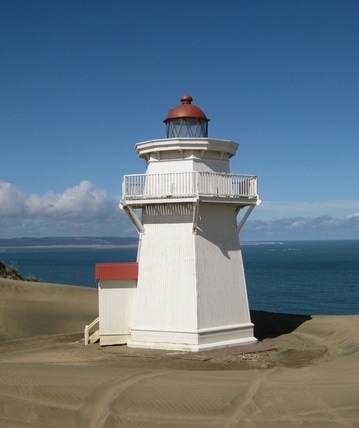
But eventually, we'll glimpse it - its white hood, peering from the top of a long and daunting face of bare sand. We slog up the slope, following the footprints of someone who came before, stopping every few minutes to catch our breath, to gaze around us; to give the dogs encouragement. We'll pull ourselves over the last ridge. And we'll stand there looking at it, thinking, "Is that it? It seems so small!"
In this landscape it is. For we're standing on a ridge some 85 metres above the sea, and the lighthouse is just 13 metres on top of (and almost nestled within) that. From here we can see across the Kaipara - to the northern edge of South Head in this direction, to the low shoreline of the Okahukura Peninsula in that; and westwards, across a rolling series of huge sand dunes, to where the coast swings north and the Tasman Sea begins.
The start of the walk is the small village of Pouto Point, some 40 km south of Dargaville, at the end of a long gravel road (so even getting to the start is quite a trek). We're at the southernmost tip of the long and ancient spit of land that closes like a jaw around the Kaipara. From here our route is westward, for some seven or eight kilometres, to a lighthouse perched on the top of a huge dune - and after that, back again.
As we set out, it's immediately clear what a wild place this is. Around us, the beach seems untidy: a ragged landscape of dunes, ridges, channels. It plays with us. Different things catch our eye, drawing us in a crazy zig-zag route. We'll follow the tracks of the quad-bikes and buggies that ferry less adventurous people to the lighthouse. More than once we'll find ourselves stranded on a small island of dry sand in a black and boggy swale, or facing a sandy slope that looks too steep and unstable to climb down. We'll poke in the piles of flotsam that the sea has spat out. We'll wander to the back of the beach and lose ourselves in the network of paths through the tea tree bush. As the tide comes in, and the beach narrows, we'll edge along the face of a dune, while the waves chew hungrily at the sand below us. We'll scour the ridge-line, looking for a sign of the lighthouse, wondering if we've missed it, if we've walked too far.
But eventually, we'll glimpse it - its white hood, peering from the top of a long and daunting face of bare sand. We slog up the slope, following the footprints of someone who came before, stopping every few minutes to catch our breath, to gaze around us; to give the dogs encouragement. We'll pull ourselves over the last ridge. And we'll stand there looking at it, thinking, "Is that it? It seems so small!"
In this landscape it is. For we're standing on a ridge some 85 metres above the sea, and the lighthouse is just 13 metres on top of (and almost nestled within) that. From here we can see across the Kaipara - to the northern edge of South Head in this direction, to the low shoreline of the Okahukura Peninsula in that; and westwards, across a rolling series of huge sand dunes, to where the coast swings north and the Tasman Sea begins.
|
But though small and dwarfed by the landscape, the lighthouse has character, charm and history. Because of its huge resources of kauri, the Kaipara Harbour was once the busiest in New Zealand. The fierce tides and shifting sandbars, however, made it a treacherous place for shipping and wrecks were common: when the tides and sand are right, we might see the skeletons of boats on the beach. A lighthouse was therefore essential, and one was erected in 1884, one of the last two made of wood to be built - and now the oldest to survive. For 63 years it was operated with a manual lamp, maintained by two lighthouse keepers who lived in adjacent cottages. In 1947, however, it was automated, and the Harbour was closed to marine shipping. By 1971, the lighthouse had fallen into disrepair, and was due to be demolished, but a group of local residents fought to have it restored, and this was done in 1982-84, just in time to celebrate its centenary. Since then its fortunes have fluctuated, and further repair was needed in 2008 after the light was damaged, as the broken remnants of glass that are scattered on the sand testify.
|
|
SummaryLocation: Pouto Point: end of Pouto Road, ca. 70 km south of Dargaville
Access: Carpark beside beach Length: ca. 7.5 km (one-way) Configuration: There-and-back Grade: Largely flat but with a steep slope up sand dune to lighthouse at the end; beach with options of informal paths in bush in places Status: off leash Cafes and restaurants: None locally More information: |
|