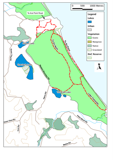
SummaryLocation: End of Te Arai Point Road, ca. 13 km south of Mangawhai: from Mangawhai, follow Insley Street south onto Mangawhai Road; in ca. 3 km turn east onto Te Ara Point Road and follow to the end.
Access: Car parks at end of Te Ara Point Road Length: up to 10km return trip Configuration: Network of paths and beach. Grade: Flat; beach and forest tracks; steep sections over Te Arai Point Status: on leash, with some off-leash (under control) areas Cafes and restaurants: Smashed Pipi and Bennett's cafes at Mangawhai, 14 km north. More information: |
DescriptionTe Arai Point is a composed of volcanic rocks, forming a small but prominent headland amidst the rolling sand dunes of the coast, south of Mangawhai. The area to the north offers habitats for a range of threatened bird species, including Fairy terns, so is off-limits for dogs. But from about 100 metres to the north of the point, southwards, dogs are welcome, both on the beach and in the the adjacent dunes. This includes a large off-leash area of rather rough regenerating scrubland.
The best walks from Te Arai Point, however, are on the headland itself, or in the nearby forest. On the headland, there's an extensive track of mown paths looping through the pasture and brush, and giving lovely views in all directions: to Pakiri in the south, Whangarei Heads in the north and the rolling hills of southern Kaipara westwards. These are all good walks, and worth spending time on. But it's also worth crossing over the headland onto the next beach, for there we come to another parking area and picnic site, and this gives us entry to the forest. We can also drive round the headland to this car-park - though be warned, the entrance road is locked at dusk - so don't be late back! The track starts as a broad and straight forest ride, with triangular way-markers. Within a few hundred metres, however, we cross an area of blow-out, where the vegetation must have been cleared at some stage, allowing the wind to take hold and hollow the sand out. After that, the track narrows and starts to wind, sometimes almost touching the beach, sometimes wandering away. In places, we come to areas of felling, and the path disappears, but the forest is relatively open, so it's easy enough to skirt these areas by picking our way between the trees until we find our track again. The forest has been planted on old dunes, to stabilise them against the wind. The path, therefore, goes up and down as it winds across the ridges. Beneath our feet, the sand changes texture and colour, depending on where we are. Coastal dunes, almost the world over, show a similar pattern, ageing as we move away from the sea. Nearest the sea, we find the yellow dunes, where the sand is still active, and the only vegetation tends to be marram grass or similar pioneer species. The sand here is fresh. Then come the grey dunes: so-called because the sand is weathering and organic matter is building up, allowing lichen and mosses to take hold. Further inland, where the dunes are older and the vegetation denser, a layer of black humus accumulates from the decaying leaf-litter and roots; this is slightly acid, so the rainwater washes the nutrients down through the soil, depositing them at greater depth. Here, a bright orange or red iron-pan forms - and we can see this where our track has cut into the soil. So if we get lost, we just look at the soil and that will tell us how far we are from the sea! (Alternatively, we can just listen - for wherever we are, we can here the constant sound of the waves breaking onto the shore.) If we want to, we can follow this track for three kilometres or more, all the way to Lake Tomarata. But we can also allow ourselves to be enticed by the sound of the waves, and take one of the many side-paths onto the beach. This stretch of the coast is straight and relatively exposed, and the wind usually seems to be blowing, making the view on the beach dissolve into a haze of spray and sand. The beach also offers us a different route home - and a chance for the dogs to have a run off-leash. |
