W2K Headland Walk
Taupo and its surrounding area offers a great range of really good dog-walks, many of them lengthy and with spectacular views. Two of our favourites start in Kinloch - pleasant little village that is worth visiting in its own right. From there, one walk heads west to Kawakawa Bay; the other goes of east over the headland into Whakaipo Bay. Together they make up what's called the W2K walk.
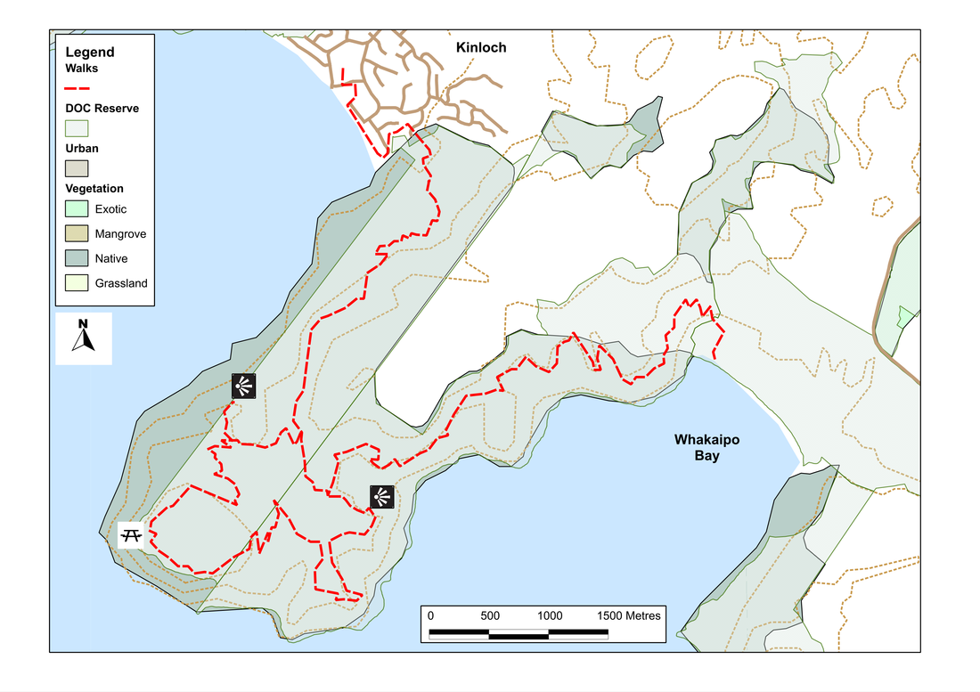
The route east is especially fruitful, for as well as the 28km (return) there-and-back route to the bay itself, there's a long loop track on the headland, which offers a rewarding half to full-day walk.
Having parked our little camper van for the night in the stopover by the information centre, we set out the next morning to explore the headland. The start of the walk - along the marina and then onto the beach - is all on-leash, but within ten minutes we've reached the boardwalk at the eastern end of the beach which leads us through a small wetland area and into woods at the base of the headland. After getting ourselves briefly lost by turning the wrong way, we figure it all out and head left, following a gently undulating path along the edge of a grassy gully for a few hundred metres, then looping round until it meets the road. On the other side, there's a grassy track which soon re-enters the bush, and the real walk starts.
As we pass the DoC signs, we're not sure what the rules area here, but from what we see of other dog-walkers it's de facto off-leash. The path heads upwards at a steady gradient, through regenerating bush with occasional grassy areas that offer views across the lake. After 2.5km, it levels off and for the next 3km it's a gentle alternation of rises and fall until we meet the first junction. Straight ahead is the track to Whakaipo Bay; right takes us on a 9.7km loop onto the headland. We go right.
After a kilometre or so of easy downhill, there's another junction where a path leads off right to the lookout. It's worth the extra distance, for from there we get a good view across Kinloch to the headland on the other side of Whangamata Bay. The dogs enjoy it too, for somewhere in the bush there's something - a pig or possum or deer - that teases their scent-glands and soon has them confined to a lead, and has us bowling along in their wake, Mozzy howling in excitement. It's an experience repeated a quarter of an hour later when we pass a possum trap, set at the side of the track; though what purpose the ping-pong ball in the bottom serves, we fail to fathom. Entertainment for them, perhaps, while they sit there, awaiting their fate.
Two kilometres from the lookout junction, we reach a small clearing sporting a large wooden bench, where we stop for lunch. Carved into it are the names of the people who built the track: lots of Peters and Davids, and a Paddy and Ukelele, Mac and Mimi, the dogs. Not to mention Colleen and Sandy who either carried the water buckets or made the cup-cakes - for the pictograms aren't quite clear!
From there, the loop track continues for another five or six km, zig-zagging around the headland, with views now and then of the lake. The day is warm now, and cicadas are in full voice. It seems such a waste of energy. Could I design a set of earphone, I wondered, that would take in the noise and translate it into something more enjoyable - Bach or Beethoven or the Bee-Gees. The evidence of them is on almost every tree: empty brown pupa cases tacked on the bark, under leaves, slowly drying and turning to dust. Briefly, the noise subsides, as we drop down and the vegetation changes; but soon it's full volume in full tremolo again as we rise up out of the valley. As we walk a refrain enters my head, and beats out my stride: I'm sick of cicadas, of cicadas I'm sick.
And then, we're at another junction, with a short path to another lookout, giving views into Whakaipo Bay. After that, it's precisely 170 metres to the main path and a sign telling us it's 6.7 km to Kinloch. That last stretch seems remarkably easy: it's downhill and soon we're back on a a familiar track, and at last we leave the noise of the cicadas behind. Only that annoying refrain stays, accompanying my every step: I'm sick of cicadas....
SummaryLocation: Kinloch, 20km west of Taupo
Access: From the carpark beside the information centre at the marina in Kinloch Length: 10-20km depending on route chosen Configuration: loop and there-and-back walks Grade: Undulating to steep; well-formed trails Status: off-leash (on-leash in some areas) Cafes and restaurants: Waterside Restaurant and Bar, Kinloch More information: http://www.taupotrampers.com/whakaipotoKinloch.pdf |
|