And the dog came too... dog walks in New Zealand
  • Home
  • Introduction
  • Notes for Users
  • Alarums and Excursions!!
  • South Island
    • North-West >
      • Atua Stream Walk
      • Barnicoat
      • Ben Nevis
      • Botanical Hill
      • Boulder Bank
      • Brooklyn
      • Collingwood Beach
      • Collingwood Cemetery
      • Cotterell Road
      • Dellside
      • Dicker Road
      • Dominion Flats
      • Eves Valley Road
      • Faulkner Bush
      • Grampians
      • Great Taste Trail - Richmond
      • Great Taste Trail - Kohatu
      • Great Taste Trail - Wakefield
      • Hacket Valley
      • Hoddy Estuary Reserve
      • Hoddy Road
      • Kawatiri Rail Tunnel walk
      • Kina Beach
      • Maitai Valley
      • Mapua Headland
      • Marahau Beach
      • Marahau Forest
      • Mead Stream
      • Milnthorpe Forest
      • Motueka Inlet
      • Motueka Spit
      • Pakawau Beach
      • Paton's Rock
      • Paynes Ford Tramline Track
      • Pearse Valley
      • Pohara Beach
      • Rameka Creek
      • Red Hills
      • Ridgeview Road Walkway
      • Robson Reserve
      • Rough Island
      • Sharlands
      • Split Apple Rock
      • Stagecoach Road
      • St Arnaud Loop Walk
      • Tahunanui Beach
      • Tantragee
      • Tasman View Road
      • Teetotal
      • Two Rivers
      • Waimea Fish-Out Ponds
      • Waimea River Trail
      • Wairoa River Left Branch
      • Waiwhero Forest
      • Waiwhero Ridge
    • North-East >
      • Archer's Track
      • Blairich Reserve
      • Cullen Creek
      • Cullen Point
      • Davies Bay Track
      • Esson's Valley Tracks
      • Goulter River
      • Grovetown Lagoon
      • Half Moon Track
      • Kotuku Trail
      • Lake Chalice
      • Link Trail East
      • Link Trail West
      • Lower Wairau
      • Mount Baldy and Mount Royal
      • Mount Barrett Walkway
      • Mount Fell
      • Mount Fishtail
      • Mount Richmond
      • Mount Riley
      • Mount Robertson
      • Mount Stokes
      • Mount Takorika
      • Ngakuta Bay
      • Nydia Track
      • Opouri Bridle Track
      • Patutu Walk
      • Pelorus Track
      • Piwakawa Track
      • Rarangi
      • Sawcut Gorge
      • Snout Tracks
      • Taylor's Valley
      • Tirohanga
      • Wairau River
      • Wakamarina Track
    • West >
      • Alborns Track
      • Big Rimu Tree walk
      • Charming Creek
      • Chasm Creek
      • Coalbrookdale
      • Denniston Historic Walkway
      • Denniston Plateau
      • Gentle Annie Point walk
      • Goldsborough Tracks
      • Haast-Paringa Cattle Track
      • Kawatiri Beach Trail
      • Kawatiri River Trail
      • Kumara Community walks
      • Lake Hanlon
      • Larry's Creek
      • Mikonui River
      • Millerton Bathhouse Track
      • Moeraki Valley Track
      • Mokihinui Stopbank
      • Mount Adams
      • Mount Glasgow
      • Mount Haast Route
      • Murchison Tree Walks
      • Murray Creek
      • Old Ghost Road
      • Porika Road
      • Powerhouse and Lookout Walks
      • Progress Water Race
      • Ross Goldfield Walks
      • Skyline Walk
      • Stafford Bay Loop
      • Wanganui River
      • Whataroa Walks
      • Whitcombe Loop Tracks
      • Whitcombe Valley Track
      • Zig-Zag Track
    • Central-North >
      • Balmoral Lookout
      • Bottle Lake
      • Cheviot Hills Reserve
      • Childrens Bay Farm
      • Craigieburn Forest
      • Culverden Domain
      • Diamond Harbour
      • Ellangowan Scenic Reserve
      • Garden of Tane
      • Godley Head
      • Governors Bay
      • Halswell Quarry
      • Hanmer Forest Walks
      • H W Hart Arboretum
      • Ka Whata Tu o Rakihouia
      • Kaikoura Trail
      • Kowai Bush Reserve
      • Kowai River
      • Lyttleton Coastal Walk
      • Lytteleton Hills
      • McCleans Forest
      • McHughs Forest Park
      • Mears Bush
      • Mount Grey
      • Mount Oxford
      • Mount Richardson
      • Mount Thomas
      • Newton Falls
      • Ngaio Point
      • Panama Rock
      • Pegasus Bay
      • Rakahuri River
      • Sign of the Bellbird
      • Sign of the Kiwi
      • St James Conservation Park
      • Tutakakahikura Scenic Reserve​
      • Victoria Park
      • West Melton Forest
      • Woodills North
      • Woodills South
    • Central-South >
      • Ahuriri East Branch
      • Ahuriri Valley Tracks
      • Ashburton River
      • Benmore Peninsula
      • Centennial Park
      • Cowan's Hill
      • Dingle Burn
      • Double Hill
      • Freehold Creek
      • Greta and Dorcy Tracks
      • Gunns Bush
      • Hook Bush
      • Huxley and Hopkins Valleys
      • Kelceys Bush
      • Knottingly Park
      • Lake Emma walk
      • Lake Emily Tracks
      • Lake Hood
      • Lake Ohau Track
      • Lake Opuha Walk
      • Lake Tekapo Lakeside Walk
      • Lake Tekapo Regional Park
      • Lake Wainono
      • Lower Opihi River Track
      • Macaulay River walk
      • Methven walkway
      • Mount Barrosa
      • Mount Sunday & Mount Potts
      • Opihi River Walkway
      • Orari River Mountain Bike Tracks
      • Pareora River
      • Pioneer Park
      • Potts River Walks
      • Quailburn Track
      • Saltwater Creek
      • Snowy Gorge
      • Talbot Forest
      • Temple Valley Tracks
      • Waihao River
      • Waihi River Walk
      • Waimate Creek walks
      • Waitohi Bush
    • South-East >
      • Alexandra Anniversary Walk
      • Arawata Bridle Track
      • Arrow Gorge Loop
      • Arrowtown Millennium Track
      • Bannockburn Sluicings
      • Bob's Cove and Twelve Mile Delta
      • Boundary Creek
      • Bull Creek
      • Bullendale Track
      • Butcher's Dam
      • Central Otago Rail Trail
      • Chrystals Beach
      • Clutha Riverside Track
      • Commissioner's Track
      • Conroy's Dam
      • Cromwell-Pisa Walkway
      • Crystal Battery
      • Deans Bank Track
      • Diamond Creek Track
      • Dunedin Walks
      • Earnscleugh Tailings
      • Flagstaff Hill
      • Frankton Arm Walkway
      • Gabriel's Gully
      • Gibbston River Trail
      • Gladstone Track
      • Glendhu Bay Track
      • Glenorchy Boardwalk
      • Grovers Hill
      • Hawea River Track
      • Huriawa Pa Walk
      • Kanuka Loop
      • Lake Alta Track
      • Lake Hayes Trail
      • Lakeside Walk
      • Leith Saddle
      • Long Beach
      • Mapoutahi
      • Mosgiel Floodbank
      • Mount Cargill
      • Mount Crichton Loop
      • Mount Iron Track
      • Munro's Gully
      • Naseby Forest
      • Nevis Valley Tracks
      • Newcastle Track
      • One MIle Creek
      • Oteake Conservation Park
      • Outram Glen
      • Quartz Reef
      • St Bathans
      • Trotters Gorge
    • South-West >
      • Blair Athol Walkway
      • Boyd Creek
      • Manapouri cycleway
      • McLean Falls
      • The Bluff
  • North Island
    • Auckland & Waiheke
    • Coromandel & North Waikato
    • Wellington
    • The North
    • Manawatu & Wairarapa
    • The East
    • Taranaki & Central
  • Useful Links
  • Progress Water Race
  • Rock and Pillar Conservation Park
  • New Page
  • New Page
  • New Page
  • New Page
  • New Page
  • New Page

Waipu Cove Walkway

A varied walk on sandy beaches and rocks, along cliff-tops, and through fields and bush from the lovely Waipu Cove

Download pdf

Summary

Location: Waipu Cove, 8 km south of Waipu.

Access: Carpark on Waipu Cove Road at south end of Waipu Cove.

Length: ca. 3 km (one-way)

Configuration: There-and-back (or loop via Waipu Cove Road)

Grade: Undulating, with some short scrambles; unmade path.

Status: on leash on private land (with off-leash sections along beasches) 

Cafes and restaurants: Cove Cafe, opposite carpark in Waipu Cove; Beach House restaurant, Waipu Cove (ca.100 metres)

More information: 
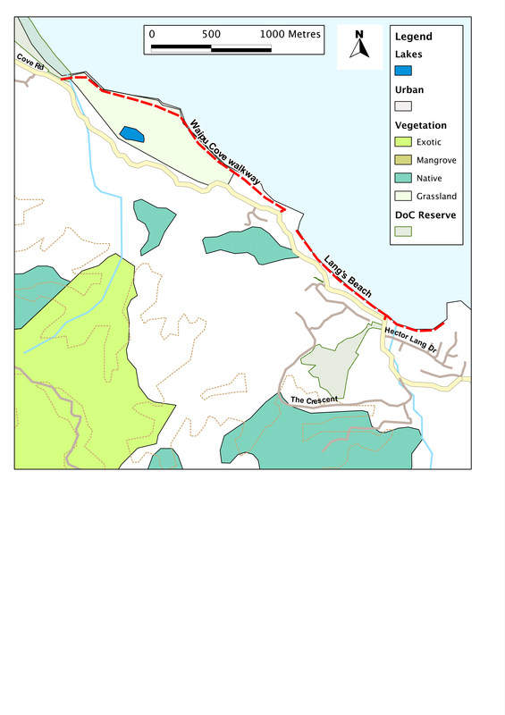
Picture

Description

The Waipu Cove Walkway has been developed and is maintained by local volunteers - and they deserve every credit for what they've achieved.  While the walk can be a bit of a scramble in places, it's worth the effort, for it takes in a lovely stretch of coastline, with gorgeous coves, some great views out to sea, and some interesting geological features to explore on the way.

The usual entry point is from the carpark at Waipu Cove; there's no parking available at the other end.  Depending on the tide and the recent weather, the start can be a bit of an adventure, for it involves crossing the small stream at the southern end of the beach.  We can often splash through, or jump across, but at times the water's just a little too wide and deep for this, and then we might need to do a bit of tight-rope walking across the handily placed tree.  After that, it's a quick climb up the rocky slope onto the bluff.  From here we can  take a detour down into a small bay which is worth it on sunny days for it's a real sun-trap.  But the main path heads off to the right, along the ridge.

The path is narrow and rough in places, as it winds its way along the slope, below a scatter of houses.  But there's plenty to look out for.  The geology here is limestone, and it creates some fascinating shapes where it has been eroded by the sea.  Waves splash and gurgle in the deep clefts; large chunks of rock lie piled below the cliffs; twisted pohutukawa trees grow from the outcrops, often with cormorants sitting in their boughs.  And after 700 metres or so, there's a particularly intriguing feature, which is impossible to miss because the path goes up and over it via a rather precarious plank.  It's called Pancake Rock, and it's obvious why, for the limestone lies in thin layers, each only a few milllimetres thick.  As the sign on the rock-face explains, they formed some 30 million years ago, through the deposition of the shells and remnants of marine organisms in warm shallow seas.  The layers show the repeated fluctuations in conditions on the sea floor, as rates of deposition varied perhaps from one year to another - before the whole area was buried and compressed by later sediments. 

Moving on, we pass through a series of grassy fields (this is private land, so keep the dog leashed here) and then down into a rocky cove.  This is a good place to linger and explore the rock-pools, or take another look at the geology - or maybe just lie on the beach and enjoy the sun.  If the tide is right, we can wander along the beach and climb up the steps at the far end; at high tide, though, there's an alternative route through the fields above the beach.

From here, the path undulates over more rocky bluffs, and down into rather damp clefts, before coming into an area of bush.  The land to the right is an important wildlife habitat, so dogs are banned, but if we stick close to the cliffs we can continue on until the path turns suddenly right and heads up the slope to the Waipu Cove Road. If we go that way we have the choice of continuing on to Langs Beach by road. This is is a lovely little spot, so worth a bit of road-walking if we have time.  Alternatively, we can complete a circuit by following the road right, back to Waipu Cove.  Otherwise, it's back the way we came - perhaps with another short rest in one of the coves... 
If you've found this website helpful, you might also want to look at some of my novels and poetry. These, like my dog-walking, are drawn from a love of nature and the countryside. To learn more, click here.