Description
Warkworth offers three, linked walks, which can easily be combined into one: the Sesquicentennial walk, the Kowhai Park walk, and the Town Riverbank walk, which takes in Lucy Moore Memorial Park.
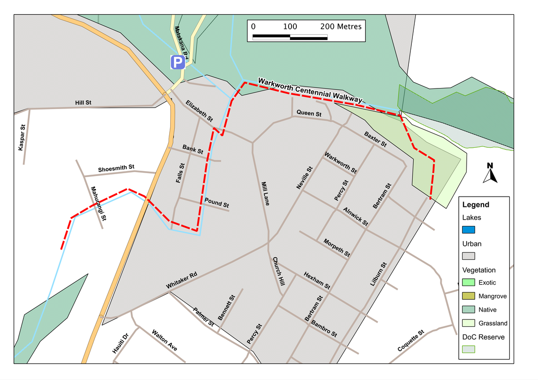
The three converge near the river bridge on Elizabeth Street, and the best place to start from is thus one of the on-street parking spots near the bridge, or the small car-park at the junction of SH1 and Sandspit Road.
From the latter, the Kowhai Park walk heads northwards, along a waymarked path, beside a small tributary of the Mahurangi River. Although short, the walk has special interest because of the old industrial relicts we pass on the way. These are the left-overs of old lime-kilns that were constructed here in 1866 to produce the cement that was used to build a range of prominent buildings both in New Zealand and Australia. In their heyday, they employed 180 men and was prosperous enough to allow the owners to set up a stately family home on the hilltop above the cement works.
To get to the other two walks we need to cross Sandspit Road from the car park (taking care because it's a complex and badly designed junction where few drivers seem to know quite what to do) and walk a little way down Elizabeth Street to the bridge. The Sesquicentenniual walk heads west from here, following the Mahurangi River in a broad meander cut into a narrow gorge. After 700 metres or so, the path climbs briefly out of the valley to a small gravel service road, then back down again to duck under SH1 to end in an area of parkland. This is unfortunately rather poorly drained, so in wet weather is best avoided; but in drier times it's a good opportunity to let the dogs run free.
The third walk - along the Town Riverbank - heads east from the bridge on Elizabeth Street, and on the opposite (i.e. south) side of the river. In many ways this is the best of the three, for it takes us past some impressive and rocky rapids, then along a neatly made wharf which is usually the birth of several attractive tall-masters. Here, the woodwork is lined with the names of all the people and companies that donated to the building of the wharf, and as we go on, we see plaques illustrating many of the ships that used to ply their way to Warkworth. A little further on, we enter Lucy Moore Memorial Park, a wide expanse of grass and clusters of trees, with a number of different paths. Lucy Moore, after whom the park is named, was born in Warkworth in 1906 and trained as a zoologist. She went on to become a leading botanist and ecologist - and though she described herself as a one of the 'jacks or jills of many trades', she received numerous awards for her work, and earned her description as 'the mother of New Zealand botany'.
SummaryLocation: Warkworth, off SH1
Access: Various options, including on-street parking on Elizabeth Street, public car park at the junction of SH1 and Sandspit Road, and riverside car parks in central Warkworth. Length: ca. 2.5 km (one way) Configuration: There-and-back (Y-shaped path with additional loop walk in Lucy Moore Memorial Park) Grade: Flat-undulating; mixture of informal tracks, boardwalk and concrete paths Status: on leash (with some off-leash areas) Cafes and restaurants: Numerous cafes in Warkworth More information: http://www.historic.org.nz/en/Publications/HeritageNZMagazine/HeritageNZ2002/HNZ02-LegacyConcrete.aspx http://www.teara.govt.nz/en/biographies/5m55/1 |
|