And the dog came too... dog walks in New Zealand
  • Home
  • Introduction
  • Notes for Users
  • Alarums and Excursions!!
  • South Island
    • North-West >
      • Atua Stream Walk
      • Barnicoat
      • Ben Nevis
      • Botanical Hill
      • Boulder Bank
      • Brooklyn
      • Collingwood Beach
      • Collingwood Cemetery
      • Cotterell Road
      • Dellside
      • Dicker Road
      • Dominion Flats
      • Eves Valley Road
      • Faulkner Bush
      • Grampians
      • Great Taste Trail - Richmond
      • Great Taste Trail - Kohatu
      • Great Taste Trail - Wakefield
      • Hacket Valley
      • Hoddy Estuary Reserve
      • Hoddy Road
      • Kawatiri Rail Tunnel walk
      • Kina Beach
      • Maitai Valley
      • Mapua Headland
      • Marahau Beach
      • Marahau Forest
      • Mead Stream
      • Milnthorpe Forest
      • Motueka Inlet
      • Motueka Spit
      • Pakawau Beach
      • Paton's Rock
      • Paynes Ford Tramline Track
      • Pearse Valley
      • Pohara Beach
      • Rameka Creek
      • Red Hills
      • Ridgeview Road Walkway
      • Robson Reserve
      • Rough Island
      • Sharlands
      • Split Apple Rock
      • Stagecoach Road
      • St Arnaud Loop Walk
      • Tahunanui Beach
      • Tantragee
      • Tasman View Road
      • Teetotal
      • Two Rivers
      • Waimea Fish-Out Ponds
      • Waimea River Trail
      • Wairoa River Left Branch
      • Waiwhero Forest
      • Waiwhero Ridge
    • North-East >
      • Archer's Track
      • Blairich Reserve
      • Cullen Creek
      • Cullen Point
      • Davies Bay Track
      • Esson's Valley Tracks
      • Goulter River
      • Grovetown Lagoon
      • Half Moon Track
      • Kotuku Trail
      • Lake Chalice
      • Link Trail East
      • Link Trail West
      • Lower Wairau
      • Mount Baldy and Mount Royal
      • Mount Barrett Walkway
      • Mount Fell
      • Mount Fishtail
      • Mount Richmond
      • Mount Riley
      • Mount Robertson
      • Mount Stokes
      • Mount Takorika
      • Ngakuta Bay
      • Nydia Track
      • Opouri Bridle Track
      • Patutu Walk
      • Pelorus Track
      • Piwakawa Track
      • Rarangi
      • Sawcut Gorge
      • Snout Tracks
      • Taylor's Valley
      • Tirohanga
      • Wairau River
      • Wakamarina Track
    • West >
      • Alborns Track
      • Big Rimu Tree walk
      • Charming Creek
      • Chasm Creek
      • Coalbrookdale
      • Denniston Historic Walkway
      • Denniston Plateau
      • Gentle Annie Point walk
      • Goldsborough Tracks
      • Haast-Paringa Cattle Track
      • Kawatiri Beach Trail
      • Kawatiri River Trail
      • Kumara Community walks
      • Lake Hanlon
      • Larry's Creek
      • Mikonui River
      • Millerton Bathhouse Track
      • Moeraki Valley Track
      • Mokihinui Stopbank
      • Mount Adams
      • Mount Glasgow
      • Mount Haast Route
      • Murchison Tree Walks
      • Murray Creek
      • Old Ghost Road
      • Porika Road
      • Powerhouse and Lookout Walks
      • Progress Water Race
      • Ross Goldfield Walks
      • Skyline Walk
      • Stafford Bay Loop
      • Wanganui River
      • Whataroa Walks
      • Whitcombe Loop Tracks
      • Whitcombe Valley Track
      • Zig-Zag Track
    • Central-North >
      • Balmoral Lookout
      • Bottle Lake
      • Cheviot Hills Reserve
      • Childrens Bay Farm
      • Craigieburn Forest
      • Culverden Domain
      • Diamond Harbour
      • Ellangowan Scenic Reserve
      • Garden of Tane
      • Godley Head
      • Governors Bay
      • Halswell Quarry
      • Hanmer Forest Walks
      • H W Hart Arboretum
      • Ka Whata Tu o Rakihouia
      • Kaikoura Trail
      • Kowai Bush Reserve
      • Kowai River
      • Lyttleton Coastal Walk
      • Lytteleton Hills
      • McCleans Forest
      • McHughs Forest Park
      • Mears Bush
      • Mount Grey
      • Mount Oxford
      • Mount Richardson
      • Mount Thomas
      • Newton Falls
      • Ngaio Point
      • Panama Rock
      • Pegasus Bay
      • Rakahuri River
      • Sign of the Bellbird
      • Sign of the Kiwi
      • St James Conservation Park
      • Tutakakahikura Scenic Reserve​
      • Victoria Park
      • West Melton Forest
      • Woodills North
      • Woodills South
    • Central-South >
      • Ahuriri East Branch
      • Ahuriri Valley Tracks
      • Ashburton River
      • Benmore Peninsula
      • Centennial Park
      • Cowan's Hill
      • Dingle Burn
      • Double Hill
      • Freehold Creek
      • Greta and Dorcy Tracks
      • Gunns Bush
      • Hook Bush
      • Huxley and Hopkins Valleys
      • Kelceys Bush
      • Knottingly Park
      • Lake Emma walk
      • Lake Emily Tracks
      • Lake Hood
      • Lake Ohau Track
      • Lake Opuha Walk
      • Lake Tekapo Lakeside Walk
      • Lake Tekapo Regional Park
      • Lake Wainono
      • Lower Opihi River Track
      • Macaulay River walk
      • Methven walkway
      • Mount Barrosa
      • Mount Sunday & Mount Potts
      • Opihi River Walkway
      • Orari River Mountain Bike Tracks
      • Pareora River
      • Pioneer Park
      • Potts River Walks
      • Quailburn Track
      • Saltwater Creek
      • Snowy Gorge
      • Talbot Forest
      • Temple Valley Tracks
      • Waihao River
      • Waihi River Walk
      • Waimate Creek walks
      • Waitohi Bush
    • South-East >
      • Alexandra Anniversary Walk
      • Arawata Bridle Track
      • Arrow Gorge Loop
      • Arrowtown Millennium Track
      • Bannockburn Sluicings
      • Bob's Cove and Twelve Mile Delta
      • Boundary Creek
      • Bull Creek
      • Bullendale Track
      • Butcher's Dam
      • Central Otago Rail Trail
      • Chrystals Beach
      • Clutha Riverside Track
      • Commissioner's Track
      • Conroy's Dam
      • Cromwell-Pisa Walkway
      • Crystal Battery
      • Deans Bank Track
      • Diamond Creek Track
      • Dunedin Walks
      • Earnscleugh Tailings
      • Flagstaff Hill
      • Frankton Arm Walkway
      • Gabriel's Gully
      • Gibbston River Trail
      • Gladstone Track
      • Glendhu Bay Track
      • Glenorchy Boardwalk
      • Grovers Hill
      • Hawea River Track
      • Huriawa Pa Walk
      • Kanuka Loop
      • Lake Alta Track
      • Lake Hayes Trail
      • Lakeside Walk
      • Leith Saddle
      • Long Beach
      • Mapoutahi
      • Mosgiel Floodbank
      • Mount Cargill
      • Mount Crichton Loop
      • Mount Iron Track
      • Munro's Gully
      • Naseby Forest
      • Nevis Valley Tracks
      • Newcastle Track
      • One MIle Creek
      • Oteake Conservation Park
      • Outram Glen
      • Quartz Reef
      • St Bathans
      • Trotters Gorge
    • South-West >
      • Blair Athol Walkway
      • Boyd Creek
      • Manapouri cycleway
      • McLean Falls
      • The Bluff
  • North Island
    • Auckland & Waiheke
    • Coromandel & North Waikato
    • Wellington
    • The North
    • Manawatu & Wairarapa
    • The East
    • Taranaki & Central
  • Useful Links
  • Progress Water Race
  • Rock and Pillar Conservation Park
  • New Page
  • New Page
  • New Page
  • New Page
  • New Page
  • New Page

Wenderholm

A short and shady stroll along a well-formed path, through semi-native bush to a small beach on the estuary of the Waiwere River.

Download pdf

Summary

Location: Wenderholm Park, near  Orewa 

Access: Carpark, 50 metres inside Wenderholm Park  

Length: 0.75 km (one-way)

Configuration: There-and-back 

Grade: Gently undulating, but with steeper sections; gravel and boardwalk; signed 

Status: on leash (with off-leash area available in adjacent field, when no stock grazing)

Cafes and restaurants: Walnut Cafe, Orewa (ca. 2km) - excellent for lunch!

More information: Map and description can be downloaded from http://regionalparks.aucklandcouncil.govt.nz/wenderholm
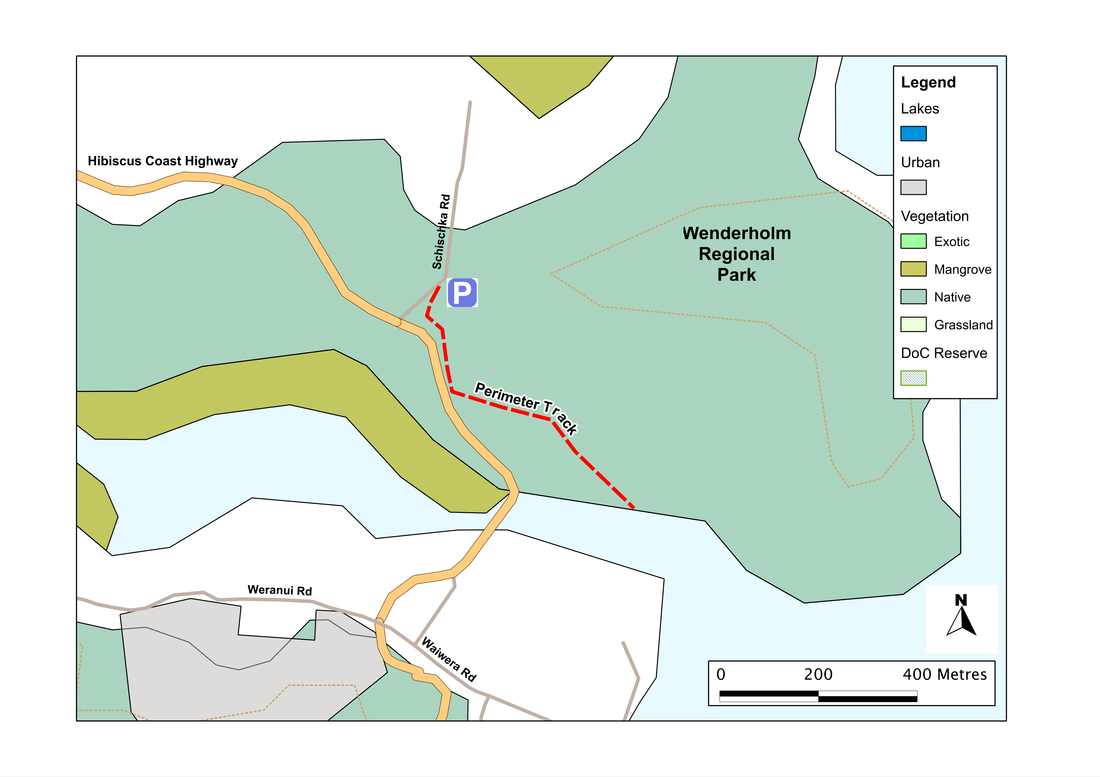
Picture

Description

Wenderholm Regional Park is managed by DOC, and therefore for the most part is closed to dogs.  We are, however, allowed access to part of one walkway – the Perimeter Track which, as its name implies, runs around the edge of the park.  Though short, it is worth exploring both because it passes through some pleasant semi-native bush, and because it gives access to a small beach on the estuary of the Waiwera River.  There are also picnic tables and a WC in the parking area.  In addition, there’s the benefit of a couple of large fields where dogs are allowed to run off-leash (but presumably not chase the pukeko that reside there) – so long as no stock are grazing.

Parking is under a row of puriri trees, on a grassy strip on the right of the entrance road, about 50 metres beyond the entrance (near the WC).  The track starts at the eastern end of this area (i.e. by the entrance) and is reached by following the raised terrace that runs at the back of the parking area.  From here, it’s a gentle climb through manuka bush, then a swing left where the track approaches the main road.  One hundred metres or so further on we reach a broader trackway that runs from a gate, and turn left along this for a few metres, then right again to follow the walkway. 

This continues, climbing over a wooded ridge, at first as a gravel track, and then as a stepped boardwalk.  At the top of the ridge, the track curves left and descends via a series of steps, then becomes a gravel track again as the terrain flattens out.  All the way, we can enjoy the rich bush, which includes the normal (for this part of Northland) mix of fern trees, nikau, manuka and taller white pine and rimu.  There are also occasional kauri.  It’s shady and cool, even on a hot summer day – though the climb may have worked up a bit of a sweat.  And bird life is usually abundant, with fantails mooning from the lower branches, wood pigeon blundering through the canopy, and tuis cooing and clucking and clunking from their perches in the pine trees. 

As we approach the estuary, the gradient of the path lessens, the vegetation thins out, and as the track curves left we come out onto a grassy terrace.  The Perimeter Path skirts this and continues on, uphill – but this is the limit of DOC’s dog-tolerance in Wenderholm. If we pick our way across the grass, however, we reach a pebbly beach beside the Waiwera River.  From here, we can look across to Waiwera – a spa town, built around a complex of hot pools (the name means ‘hot water’) .  Depending on the state of the tide, we can explore downstream a short way.  But then it’s back the way we came.

If you've found this website helpful, you might also want to look at some of my novels and poetry. These, like my dog-walking, are drawn from a love of nature and the countryside. To learn more, click here.