And the dog came too... dog walks in New Zealand
  • Home
  • Introduction
  • Notes for Users
  • Alarums and Excursions!!
  • South Island
    • North-West >
      • Atua Stream Walk
      • Barnicoat
      • Ben Nevis
      • Botanical Hill
      • Boulder Bank
      • Brooklyn
      • Collingwood Beach
      • Collingwood Cemetery
      • Cotterell Road
      • Dellside
      • Dicker Road
      • Dominion Flats
      • Eves Valley Road
      • Faulkner Bush
      • Grampians
      • Great Taste Trail - Richmond
      • Great Taste Trail - Kohatu
      • Great Taste Trail - Wakefield
      • Hacket Valley
      • Hoddy Estuary Reserve
      • Hoddy Road
      • Kawatiri Rail Tunnel walk
      • Kina Beach
      • Maitai Valley
      • Mapua Headland
      • Marahau Beach
      • Marahau Forest
      • Mead Stream
      • Milnthorpe Forest
      • Motueka Inlet
      • Motueka Spit
      • Pakawau Beach
      • Paton's Rock
      • Paynes Ford Tramline Track
      • Pearse Valley
      • Pohara Beach
      • Rameka Creek
      • Red Hills
      • Ridgeview Road Walkway
      • Robson Reserve
      • Rough Island
      • Sharlands
      • Split Apple Rock
      • Stagecoach Road
      • St Arnaud Loop Walk
      • Tahunanui Beach
      • Tantragee
      • Tasman View Road
      • Teetotal
      • Two Rivers
      • Waimea Fish-Out Ponds
      • Waimea River Trail
      • Wairoa River Left Branch
      • Waiwhero Forest
      • Waiwhero Ridge
    • North-East >
      • Archer's Track
      • Blairich Reserve
      • Cullen Creek
      • Cullen Point
      • Davies Bay Track
      • Esson's Valley Tracks
      • Goulter River
      • Grovetown Lagoon
      • Half Moon Track
      • Kotuku Trail
      • Lake Chalice
      • Link Trail East
      • Link Trail West
      • Lower Wairau
      • Mount Baldy and Mount Royal
      • Mount Barrett Walkway
      • Mount Fell
      • Mount Fishtail
      • Mount Richmond
      • Mount Riley
      • Mount Robertson
      • Mount Stokes
      • Mount Takorika
      • Ngakuta Bay
      • Nydia Track
      • Opouri Bridle Track
      • Patutu Walk
      • Pelorus Track
      • Piwakawa Track
      • Rarangi
      • Sawcut Gorge
      • Snout Tracks
      • Taylor's Valley
      • Tirohanga
      • Wairau River
      • Wakamarina Track
    • West >
      • Alborns Track
      • Big Rimu Tree walk
      • Charming Creek
      • Chasm Creek
      • Coalbrookdale
      • Denniston Historic Walkway
      • Denniston Plateau
      • Gentle Annie Point walk
      • Goldsborough Tracks
      • Haast-Paringa Cattle Track
      • Kawatiri Beach Trail
      • Kawatiri River Trail
      • Kumara Community walks
      • Lake Hanlon
      • Larry's Creek
      • Mikonui River
      • Millerton Bathhouse Track
      • Moeraki Valley Track
      • Mokihinui Stopbank
      • Mount Adams
      • Mount Glasgow
      • Mount Haast Route
      • Murchison Tree Walks
      • Murray Creek
      • Old Ghost Road
      • Porika Road
      • Powerhouse and Lookout Walks
      • Progress Water Race
      • Ross Goldfield Walks
      • Skyline Walk
      • Stafford Bay Loop
      • Wanganui River
      • Whataroa Walks
      • Whitcombe Loop Tracks
      • Whitcombe Valley Track
      • Zig-Zag Track
    • Central-North >
      • Balmoral Lookout
      • Bottle Lake
      • Cheviot Hills Reserve
      • Childrens Bay Farm
      • Craigieburn Forest
      • Culverden Domain
      • Diamond Harbour
      • Ellangowan Scenic Reserve
      • Garden of Tane
      • Godley Head
      • Governors Bay
      • Halswell Quarry
      • Hanmer Forest Walks
      • H W Hart Arboretum
      • Ka Whata Tu o Rakihouia
      • Kaikoura Trail
      • Kowai Bush Reserve
      • Kowai River
      • Lyttleton Coastal Walk
      • Lytteleton Hills
      • McCleans Forest
      • McHughs Forest Park
      • Mears Bush
      • Mount Grey
      • Mount Oxford
      • Mount Richardson
      • Mount Thomas
      • Newton Falls
      • Ngaio Point
      • Panama Rock
      • Pegasus Bay
      • Rakahuri River
      • Sign of the Bellbird
      • Sign of the Kiwi
      • St James Conservation Park
      • Tutakakahikura Scenic Reserve​
      • Victoria Park
      • West Melton Forest
      • Woodills North
      • Woodills South
    • Central-South >
      • Ahuriri East Branch
      • Ahuriri Valley Tracks
      • Ashburton River
      • Benmore Peninsula
      • Centennial Park
      • Cowan's Hill
      • Dingle Burn
      • Double Hill
      • Freehold Creek
      • Greta and Dorcy Tracks
      • Gunns Bush
      • Hook Bush
      • Huxley and Hopkins Valleys
      • Kelceys Bush
      • Knottingly Park
      • Lake Emma walk
      • Lake Emily Tracks
      • Lake Hood
      • Lake Ohau Track
      • Lake Opuha Walk
      • Lake Tekapo Lakeside Walk
      • Lake Tekapo Regional Park
      • Lake Wainono
      • Lower Opihi River Track
      • Macaulay River walk
      • Methven walkway
      • Mount Barrosa
      • Mount Sunday & Mount Potts
      • Opihi River Walkway
      • Orari River Mountain Bike Tracks
      • Pareora River
      • Pioneer Park
      • Potts River Walks
      • Quailburn Track
      • Saltwater Creek
      • Snowy Gorge
      • Talbot Forest
      • Temple Valley Tracks
      • Waihao River
      • Waihi River Walk
      • Waimate Creek walks
      • Waitohi Bush
    • South-East >
      • Alexandra Anniversary Walk
      • Arawata Bridle Track
      • Arrow Gorge Loop
      • Arrowtown Millennium Track
      • Bannockburn Sluicings
      • Bob's Cove and Twelve Mile Delta
      • Boundary Creek
      • Bull Creek
      • Bullendale Track
      • Butcher's Dam
      • Central Otago Rail Trail
      • Chrystals Beach
      • Clutha Riverside Track
      • Commissioner's Track
      • Conroy's Dam
      • Cromwell-Pisa Walkway
      • Crystal Battery
      • Deans Bank Track
      • Diamond Creek Track
      • Dunedin Walks
      • Earnscleugh Tailings
      • Flagstaff Hill
      • Frankton Arm Walkway
      • Gabriel's Gully
      • Gibbston River Trail
      • Gladstone Track
      • Glendhu Bay Track
      • Glenorchy Boardwalk
      • Grovers Hill
      • Hawea River Track
      • Huriawa Pa Walk
      • Kanuka Loop
      • Lake Alta Track
      • Lake Hayes Trail
      • Lakeside Walk
      • Leith Saddle
      • Long Beach
      • Mapoutahi
      • Mosgiel Floodbank
      • Mount Cargill
      • Mount Crichton Loop
      • Mount Iron Track
      • Munro's Gully
      • Naseby Forest
      • Nevis Valley Tracks
      • Newcastle Track
      • One MIle Creek
      • Oteake Conservation Park
      • Outram Glen
      • Quartz Reef
      • St Bathans
      • Trotters Gorge
    • South-West >
      • Blair Athol Walkway
      • Boyd Creek
      • Manapouri cycleway
      • McLean Falls
      • The Bluff
  • North Island
    • Auckland & Waiheke
    • Coromandel & North Waikato
    • Wellington
    • The North
    • Manawatu & Wairarapa
    • The East
    • Taranaki & Central
  • Useful Links
  • Progress Water Race
  • Rock and Pillar Conservation Park
  • New Page
  • New Page
  • New Page
  • New Page
  • New Page
  • New Page

Woodhill Forest, Helensville

An extensive network of walks through pine-clad sand dunes only 45 minutes from Auckland.

Download pdf

Summary

Location: Woodhill Forest, Helensville

Access: Parking area at end of Rimmer Road, off SH16

Length: up to 10 km

Configuration: Network of tracks, with access to beach

Grade: Flat with some steep dune sections; sandy tracks and beach 

Status: off leash  

Cafes and restaurants: None locally

More information: http://www.woodhillforest.co.nz/forest-closures/
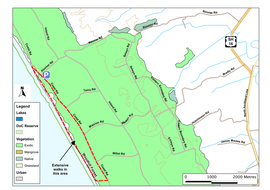
Picture
Addendum

Email received regarding Woodpile Forest


All of the information to the public on this page apart from, there is public access to the beach for walking your dog via Rimmers Road, is incorrect.
As land owners and managers of Woodhill forest we have a system where all visitors to any part of the forest must be permitted before entering.
As we are an operational forest we currently have three harvesting crews moving through the forest, various other operations, including bird shooting and hunting in different blocks, the message from your site is in direct conflict with our Health and Safety policy and is endangering members of the public.
Please remove all references to walking dogs within Woodhill forest from your site.  When we are able to designate an area for dog walking and we can ensure the safety of visitors, you will find that information on our website, www.woodhillforest.co.nz.
We thank you in advance for your swift action to ensure public safety.


Description

Woodhill Forest is a large expanse of pine and other conifers, planted to help stabilise the dunes (and, of course, to provide some profit from timber).  For many years, the forest has been extensively used for dog-walking , and in 2013 I wrote:

It's possible to enter the forest, and find walks, at several different locations.  One of the best is probably at the end of Rimmer Road, where there's a large car park, from which several tracks and trails lead out into the forest or down to the beach.  Where we go is more-or-less up to us.  The beach is a few hundred metres away, the forest stretches north and south for as far as we're likely to walk.  Not all of it is open to the public, but the tracks that are give access to a huge network of smaller, informal trails in which we can easily lose ourselves.  

Like others on the west coast, the beach is long, straight, sandy and wild.  On most days the sea either heaves or hurls itself onto the sand, so that we look down the beach through a grey haze of spray, and walk to the constant accompaniment of its roar or snore.  The beach is also the play area for four-wheel-drivers and motorcyclists so it's worth keeping ears and eyes open both on the sand and on the tracks that leach down to the beach.  They especially like trying to climb the steep dune faces, a game which may be fun but doesn't do the dunes much good.  

In the forest things are quieter, and it's surprising how soon the sound of the sea fades to a sigh, and then to little more than a whisper.  The main tracks are straight and easy to follow - and with even the most minimal sense of direction it's hard to get lost as long as we stay on them. But the smaller tracks inevitably tempt us, and they weave and wander through the trees in a bewildering fashion, and often don't go quite where we expect.  At the edge of the forest, too, some of these peter out on the back of huge sand-ridges.  Climbing these is more difficult than it looks, for the sand is loose, and there's often just another dune waiting for us when we cross this one. Short walks, therefore, can easily become much longer than intended (which is fine if we've time on our hands and some sandwiches in our pack - and water on a warm day)
.      

In August 2015, however, I received the email shown to the left, from Tania Richards, Administrator NMWoKIL, Woodpile. 

Whether or not dog-walking is still permitted, other than for access to the beach, is currently unclear - though friends report (November 2015) that dog-walking is still extensively carried out. It can also be argued that public safety is a rather over-used argument for restricting access to forests (and other areas) in New Zealand. In other countries (UK for example), public access to working forests is common, and accidents are rare. It might also be expected that forestry workers would exert due care when working, whether the public had rights of access or not. However, it should be noted that the forestry industry in New Zealand,has a very poor record of safety standards - with some of the highest death and injury rates amongst workers of any industry in the country, and amongst the worst in the developed world. So my advice would be: wherever you are in forests areas, take care.
If you've found this website helpful, you might also want to look at some of my novels and poetry. These, like my dog-walking, are drawn from a love of nature and the countryside. To learn more, click here.