Batley
Today, Batley comprises one beautiful balustraded house, perched on the hillside, with sweeping views of the Harbour. In the past, however, it was a thriving settlement with two wharves, a school, church, flour mill and two fish-canning factories - and the house that now stands there was a hotel.
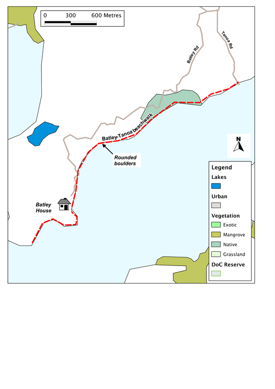
From the small grassy parking area, behind the remaining two boat-sheds, we can walk in either direction. Straight on, past the end of Batley Road, takes us to a shingle spit that juts out into the broad Otamatea River (more a branch of the sea here than a stream). On past that and we walk below shaley white cliffs and sweeping fields, to a small dry lagoon trapped behind the storm beach. After about a kilometre, we come to another headland (Ngaupiko Point) from where we can look south-west past the Tinopai Peninsula towards Pouto Point and the open sea. Continue on, beneath the cliffs, and we are soon heading north up another tentacle of this complex octopus of a feature that's called Kaipara Harbour.
Starting off in the other direction from where we parked the car may seem less enticing, for that way the Otamatea narrows in on us, and the views are constrained. But there are two reasons to do so. We meet one within a few hundred metres, when we come across large round boulders, some as tall as ourselves. They seem odd things to find in this quiet backwater: not storm-tossed and rounded by waves, surely, so how did they get here?
Boulders like these are rare, but there is a scatter of famous examples across the world, including some spectacular ones in Argentina and the USA (see photographs at http://irna.lautre.net/Tout-ce-que-la-nature-ne-peut-pas,45.html). In New Zealand the most well-known are the Moeraki Boulders on the east coast of South Island, though some interesting examples also occur at Sandspit. Despite detailed study of many of these examples, the processes remain uncertain. The most likely explanation is that they form through the slow accretion of calcite and other chemicals from the water, around an obstacle such as a fossil or mud-ball. This occurred not on the sea-floor, but at some depth in the mud that lay there there millions of years ago. The process is slow, so the boulders at Batley probably took a million or more years to form. Millions of years later, long after the mud had become compressed into rock and lifted up above sea level by geological forces, they were uncovered by erosion.
The other reason for walking this way is to visit the church at Tanoa, about two kilometres further on. The church was built in 1874 by William Gittos (or more truthfully, by the local Maori population on his behalf), an early Methodist missionary. Probably not accidentally, the site chosen was that of the last cannibal feast in the Otamatea area. The church survived in its original location until 1936, but then was damaged in severe storms. When it was rebuilt, it was shifted away from the river and turned ninety degrees to help protect it from the wind. By the early 1960s, it was in a poor state of decay again, and this time it was made smaller and the roof lowered to keep the costs down. The latest restoration took place in 2010.
There's much more to the story of this area, and Batley is a good place to dip into it. To find out more, you can do no better than read the fascinating book called Love at the end of the road, written by Rae Roadley who lives in the house today.
SummaryLocation: End of Batley Road (extension from Bickerstaffe Road), ca. 17 km south of Maungaturoto
Access: Small parking area near Batley House Length: up to 2km one-way (east towards Tanoa or west round the headland) Configuration: There-and-back Grade: Flat; shingle beach Status: off leash (under control) Cafes and restaurants: Sugarbelles and Beejays cafe in Maungaturoto, 17 km north. More information: Rae Roadley 2011 Love at the end of the road. Penguin |
|