Sandspit
Description
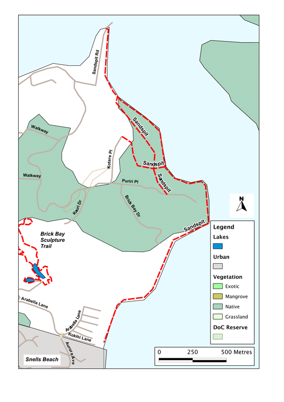
Somewhere at Sandspit there must be a - well, a sand spit. If so, it's probably worth visiting. From our experience, though, it's the rocks rather than the sand that make the place special. For if we go to the end of Sandspit Road, and turn right along the shoreline, we cross a geological wonderland, a cornucopia, a magic carpet of strangely patterned rocks.
If we want, we can walk all the way to Snells Beach and back - a distance of 3 km or so each way. Such is the fascination of the rocks, however, that it's likely to take a long time, for there's always the temptation to stop and marvel at just one more. So as an alternative - and to get the same amount of exercise in a shorter distance - we can walk down the beach for a kilometre or so, until we reach the headland, then turn back as far as the grassy glade, then do a loop up into the bush that stretches down the hillside. Be warned, though, this involves some steep climbing, and in places can be slippery.
It's the rocks, though, that bring us here and grab our attention while we are here. They're exposed in a broad wave-cut platform - a bench carved by the sea at the foot of the headland. It probably wasn't the present sea that did it, for in places the platform disappears under quite a depth of sand and gravel. So it's an ancient shoreline that is now being re-exposed.
What we now see are strange circles and rings, swirls and mounds, hundreds of them, packed together like onions in a box. The biggest are a metre or so across, rather flat at the centre, but with a series of concentric ridges around the edge. In the middle, there's often a dimple where the water gathers. What are they? How did they form?
The usual resort of the puzzled - searching the web - doesn't throw up any ideas at all. As far as that's concerned, the place seems to be unknown. So we'll just have to work it out for ourselves. The remnants of mud-pools perhaps, formed long ago when hot waters bubbled up through the soft clay? Seems possible. Or mudballs, formed as lumps of clay rolled around on the shoreline, gradually gathering more clay around themselves, like layers of armour, and now sliced in half. Less likely, surely, for some of the 'balls' are huge, and would have required a vast force to move them - and how could that happen without them breaking? And in any case, they are so tightly packed together that they'd have had no room to move.
More likely, it seems, they're another example of the mud boulders that we find elsewhere. Most famously, perhaps, at Moereki on South Island, but in this part of the world at several places in Northland, including Koutu Point and the beach near Batley. In those, most of the boulders stand proud on the beach, and are seen as a whole. Here, they've been packed together, then sliced through by the sea, to reveal their insides. If so, then they must have formed not on the seafloor, but below it, as chemicals slowly migrated through the mud, and precipitated out around obstacles such as rock crystals or fossils.
Whatever their origin, they now form one of the small wonders of the world, and they're worth a visit. And while we're there, it's fun to try to come up with new ideas about their formation - then testing them by looking carefully at the evidence. And while we crawl around on our hands and knees, trying to make sense of it all, the dogs are happy sniffing at the back of the beach, following clues of their own....
SummaryLocation: Beach adjacent to the holiday park on Sandspit Road, Sandspit
Access: Car-parks beside Sandspit Reserve Length: up to 3 km each way Configuration: there-and-back Grade: Flat, beach walk, with option of steep side-tracks through bush Status: off-leash Cafes and restaurants: Cafe Sandspit at end of peninsula (ca. 1km) More information: |
|